File:Earth's_City_Lights_by_DMSP,_1994-1995_(medium).png
De Wikipedia, la enciclopedia encyclopedia
Ver la imagen en su resolución original (2560 × 1280 píxeles; tamaño de archivo: 2,56 MB; tipo MIME: image/png)
|
|
Este es un archivo de Wikimedia Commons, un depósito de contenido libre hospedado por la Fundación Wikimedia. Más abajo se reproduce su página de descripción con la información sobre su origen y licencia. |
Resumen
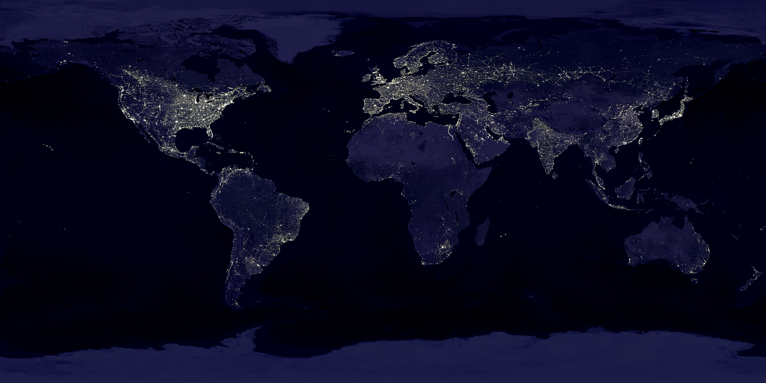
| DescripciónEarth's City Lights by DMSP, 1994-1995 (medium).png |
English: This image of Earth’s city lights was created with data from the Defense Meteorological Satellite Program (DMSP) Operational Linescan System (OLS). Originally designed to view clouds by moonlight, the OLS is also used to map the locations of permanent lights on the Earth’s surface.
The brightest areas of the Earth are the most urbanized, but not necessarily the most populated. (Compare western Europe with China and India.) Cities tend to grow along coastlines and transportation networks. Even without the underlying map, the outlines of many continents would still be visible. The United States interstate highway system appears as a lattice connecting the brighter dots of city centers. In Russia, the Trans-Siberian railroad is a thin line stretching from Moscow through the center of Asia to Vladivostok. The Nile River, from the Aswan Dam to the Mediterranean Sea, is another bright thread through an otherwise dark region. Even more than 100 years after the invention of the electric light, some regions remain thinly populated and unlit. Antarctica is entirely dark. The interior jungles of Africa and South America are mostly dark, but lights are beginning to appear there. Deserts in Africa, Arabia, Australia, Mongolia, and the United States are poorly lit as well (except along the coast), along with the boreal forests of Canada and Russia, and the great mountains of the Himalaya. |
| Fecha |
entre 1 de octubre de 1994 y 31 de marzo de 1995 date QS:P,+1994-00-00T00:00:00Z/8,P1319,+1994-10-01T00:00:00Z/11,P1326,+1995-03-31T00:00:00Z/11 |
| Fuente | https://visibleearth.nasa.gov/view.php?id=55167 (image link) |
| Autor | Data: Marc Imhoff/NASA GSFC, Christopher Elvidge/NOAA NGDC; Image: Craig Mayhew and Robert Simmon/NASA GSFC |
| Otras versiones |
|
.jpg)
.jpg)
.png)

Licencia
| Public domainPublic domainfalsefalse |
| Este archivo es de dominio público porque fue creado por la NASA. Las políticas sobre copyright de la NASA estipulan que «el material de la NASA no está protegido con copyright a menos que se indique lo contrario». (Políticas sobre copyright de la NASA o Políticas sobre la utilización de imágenes del Jet Propulsion Laboratory). | ||
 |
Advertencias:
|
| Public domainPublic domainfalsefalse |
Esta imagen es de dominio público porque contiene material que vino originalmente de la Administración Nacional Oceánica y Atmosférica de los Estados Unidos de América, recibidas o hechas en el curso de las funciones oficiales de un empleado.
العربية ∙ čeština ∙ Deutsch ∙ Zazaki ∙ English ∙ español ∙ eesti ∙ suomi ∙ français ∙ hrvatski ∙ magyar ∙ italiano ∙ 日本語 ∙ 한국어 ∙ македонски ∙ മലയാളം ∙ Plattdüütsch ∙ Nederlands ∙ polski ∙ português ∙ română ∙ русский ∙ sicilianu ∙ slovenščina ∙ Türkçe ∙ Tiếng Việt ∙ 简体中文 ∙ 繁體中文 ∙ +/− |
Leyendas
Elementos representados en este archivo
representa a
image/png
Historial del archivo
Haz clic sobre una fecha y hora para ver el archivo tal como apareció en ese momento.
| Fecha y hora | Miniatura | Dimensiones | Usuario | Comentario | |
|---|---|---|---|---|---|
| actual | 18:49 15 abr 2017 | | 2560 × 1280 (2,56 MB) | Huntster | Standardise appearance in series. |
| 20:45 9 mar 2009 |  | 2560 × 1364 (2,18 MB) | Tryphon | Higher resolution. | |
| 15:05 18 sep 2007 |  | 1499 × 797 (658 kB) | Jonathan Kovaciny~commonswiki | Re-cropped version of original NASA image. | |
| 15:03 18 sep 2007 |  | 1521 × 797 (667 kB) | Jonathan Kovaciny~commonswiki | Cropped version of the original NASA image. | |
| 16:26 30 mar 2007 |  | 1500 × 1125 (1,61 MB) | Laur2ro | {{Information |Description=Earth lights, image is slightly edited (increased contrast and brightness; similar to Image:Whole world - at night.png, but the continents are visible also). |Source=http://visibleearth.nasa.gov/view_rec.php?id=11793 |Date=m |
Usos del archivo
No hay páginas que enlacen a este archivo.
Uso global del archivo
Las wikis siguientes utilizan este archivo:
- Uso en ar.wikipedia.org
- Uso en ca.wikipedia.org
- Uso en en.wikipedia.org
- Uso en en.wikiquote.org
- Uso en en.wikiversity.org
- Uso en es.wikinews.org
- Uso en fr.wikipedia.org
- Uso en fr.wikiversity.org
- Uso en ha.wikipedia.org
- Uso en hi.wikipedia.org
- Uso en hr.wikipedia.org
- Uso en it.wikipedia.org
- Uso en mwl.wikipedia.org
- Uso en pl.wikipedia.org
- Uso en ru.wikipedia.org
- Uso en sh.wikipedia.org
- Uso en uk.wikipedia.org
- Uso en uz.wikipedia.org
- Uso en www.wikidata.org
Metadatos
Este archivo contiene información adicional, probablemente añadida por la cámara digital o el escáner usado para crearlo o digitalizarlo.
Si el archivo ha sido modificado desde su estado original, pueden haberse perdido algunos detalles.
| Fecha y hora de modificación del archivo | 18:47 15 abr 2017 |
|---|---|
| Resolución horizontal | 15,11 dpc |
| Resolución vertical | 15,11 dpc |
.png)