Archivo:1818_Pinkerton_Map_of_of_La_Plata_(Southern_South_America,_Argentina,_Chile,_Bolivia)_-_Geographicus_-_LaPlata-pinkerton-1818.jpg
De Wikipedia, la enciclopedia encyclopedia
Ver la imagen en su resolución original (3618 × 5000 píxeles; tamaño de archivo: 5,17 MB; tipo MIME: image/jpeg)
|
|
Este es un archivo de Wikimedia Commons, un depósito de contenido libre hospedado por la Fundación Wikimedia. Más abajo se reproduce su página de descripción con la información sobre su origen y licencia. |
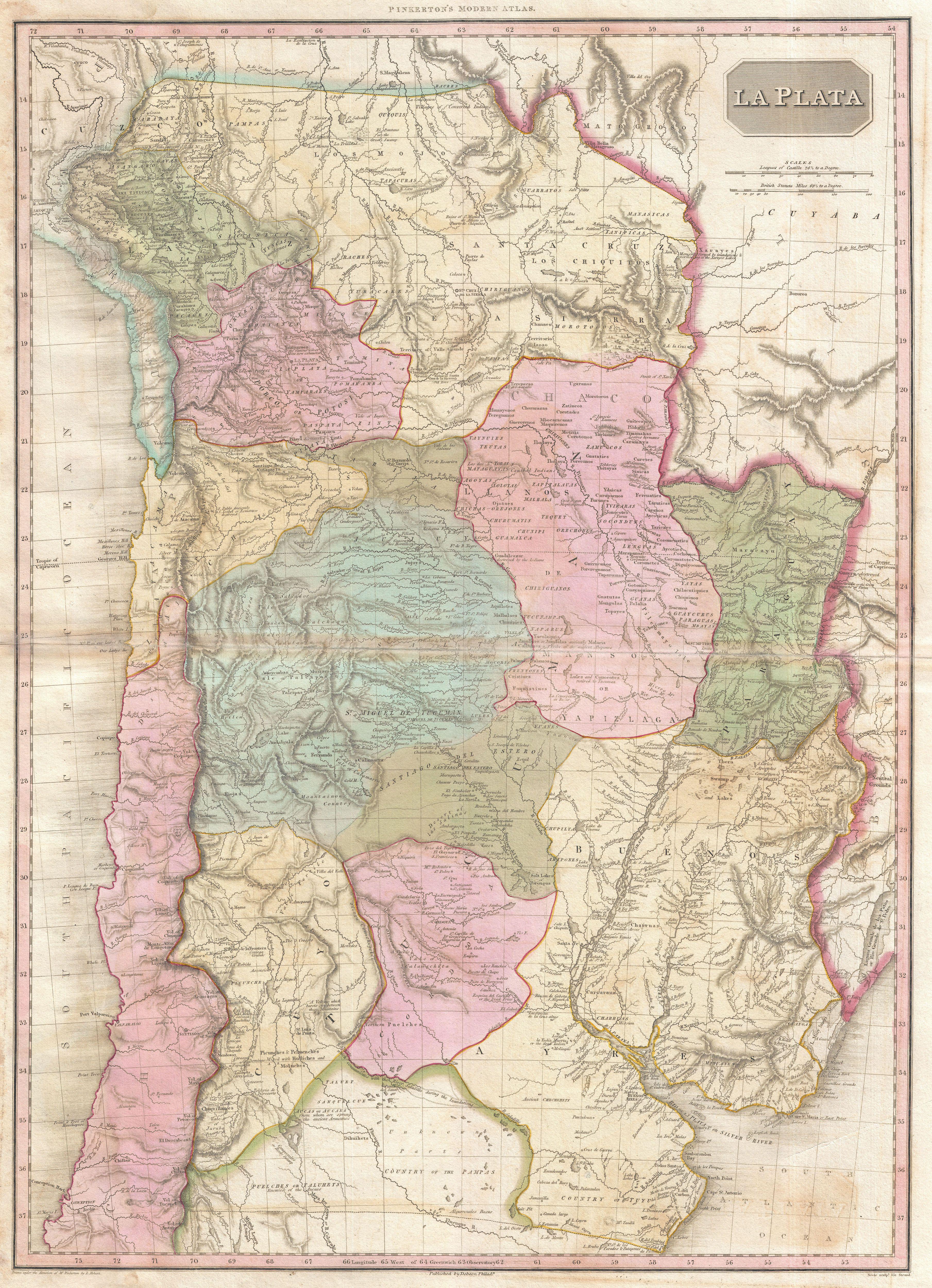
| John Pinkerton: La Plata.
( |
|||||||||||||||||||||
|---|---|---|---|---|---|---|---|---|---|---|---|---|---|---|---|---|---|---|---|---|---|
| Artista |
artist QS:P170,Q3446354 |
||||||||||||||||||||
| Título |
La Plata. |
||||||||||||||||||||
| Descripción |
English: An altogether extraordinary 1818 map of the southern parts of South America by John Pinkerton. Covers the modern day countries of Argentina, Bolivia, Paraguay, Chile as well as parts of adjacent Brazil and Peru. Pinkerton offers impressive detail throughout noting indigenous groups, missions, towns and cities, swamps, mountains, and river systems. Upper left hand quadrant features the title plate and two distance scales, one in British Miles and the other in Castile Leagues. Cartographically speaking this is an often neglected part of the world - especially in the early 19th century. Though the coastlands and open plains had been well mapped early in the 16th century, the interior was rarely penetrated. The combination of mountainous terrain, daunting jungles, malaria, and unfriendly indigenous groups combine to make this area all but unexplorable - even today. Nonetheless, Pinkerton make a commendable attempt to piece together early conquistador accounts, explorer's journals, missionary records, and indigenous reports into a coherent mapping of the area. In doing so he achieves a number of significant advances in the mapping of the region. In general, this map reads like a litany of disappointment. The number if ruined towns, abandoned missions, forgotten mines, and destroyed settlements would be hard to match in any other map. Pinkerton notes the ruins of La Conception, St. Isabel, Santa Cruz de la Sierra, and Guadalcazar to name but a few. In the Andes, he identifies the sites of a number of important mountains and volcanoes including Aconcagua, Coquimbo, Petoroa, and others. He also identifies the site of the majestic ruined pre-Columbian city on the shores of Lake Titicaca. Traditionally cartographers identified the apocryphal Lake of Xarayes as the source of the Paraguay River. In earlier days, explores associated this lake with legends of Paradise, El Dorado, and the gateway to the Amazon. The lake itself, though never existed. Instead it was a misinterpretation of the vast Pantanal flood plain during the rainy season. Here Pinkerton abandons the notation of a Lakes of Xarayes, instead identifying numerous Lakes of Xarayes, and in doing so come much closer to the truth. This is the first map to exhibit this change which is itself a significant advance the mapping of the Amazon Basin. Drawn by L. Herbert and engraved by Samuel Neele under the direction of John Pinkerton. This map comes from the scarce American edition of Pinkerton’s Modern Atlas, published by Thomas Dobson & Co. of Philadelphia in 1818. |
||||||||||||||||||||
| Fecha | 1818 (undated) | ||||||||||||||||||||
| Dimensiones |
altura: 28 in (71,1 cm); ancho: 20 in (50,8 cm) dimensions QS:P2048,28U218593 dimensions QS:P2049,20U218593 |
||||||||||||||||||||
| Número de inventario |
Geographicus link: LaPlata-pinkerton-1818 |
||||||||||||||||||||
| Fuente/fotógrafo |
Pinkerton, J., A Modern Atlas, from the Lates and Best Authorities, Exhibiting the Various Divisions of the World with its chief Empires, Kingdoms, and States; in Sixty Maps, carefully reduced from the Larges and Most Authentic Sources. 1818, Philadelphia, Thomas Dobson Edition.
|
||||||||||||||||||||
| Permiso (Reutilización de este archivo) |
|
||||||||||||||||||||

Leyendas
Elementos representados en este archivo
representa a
image/jpeg
737266836cf7b57288f349c6b9e4b24d27f5ddb4
5 417 759 byte
5000 píxel
3618 píxel
Historial del archivo
Haz clic sobre una fecha y hora para ver el archivo tal como apareció en ese momento.
| Fecha y hora | Miniatura | Dimensiones | Usuario | Comentario | |
|---|---|---|---|---|---|
| actual | 07:10 23 mar 2011 | | 3618 × 5000 (5,17 MB) | BotMultichillT | {{subst:User:Multichill/Geographicus |link=http://www.geographicus.com/P/AntiqueMap/LaPlata-pinkerton-1818 |product_name=1818 Pinkerton Map of of La Plata (Southern South America, Argentina, Chile, Bolivia) |map_title=La Plata. |description=An altogether |
Usos del archivo
Las siguientes páginas usan este archivo:
Uso global del archivo
Las wikis siguientes utilizan este archivo:
- Uso en ast.wikipedia.org
- Uso en ca.wikipedia.org
_-_Geographicus_-_LaPlata-pinkerton-1818.jpg)