User:Ruhrfisch/Maps
From Wikipedia, the free encyclopedia
Some of the Maps and Images I have made
Note: all are on Wikimedia Commons
 Larrys Creek Watershed Map
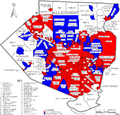
 Maps of Pennsylvania Public School Districts in all Counties with more that one school district (here Allegheny County, 63 maps total)
 White Deer Hole Creek Watershed Map
 Map of Major Watersheds in Lycoming County, Pennsylvania
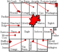 Map of Hancock County, Ohio USA and locator maps of all of its Townships, Villages, and Cities (30 maps total)
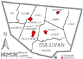 Map of Sullivan County, Pennsylvania USA and locator maps of all of its Townships and Boroughs (14 maps total)
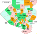
 Map of Lycoming County, Pennsylvania USA and locator maps of all of its Townships, Boroughs, and Cities (54 maps total)
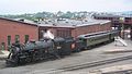 Canadian National #3254 steam engine waiting to pull two passenger cars on a tour of the Steamtown NHS yard (plus two other photos there)
 The Larrys Creek covered bridge (plus three other photos there)
 Glory of the snow (plus one other photo there)
 White Deer Hole Creek (plus five other photos there)
 A scene in the Pyrenees
 Forksville Covered Bridge over Loyalsock Creek
 Loyalsock Creek in Worlds End State Park (on the Main Page in Did You Know... on December 18, 2006)


Panoramas


