User:Ɱ/Portal:Columbus, Ohio
From Wikipedia, the free encyclopedia
Portal maintenance status: (October 2021)
|
Introduction

Columbus (/kəˈlʌmbəs/, kə-LUM-bəs) is the capital and most populous city of the U.S. state of Ohio. With a 2020 census population of 905,748, it is the 14th-most populous city in the U.S., the second-most populous city in the Midwest after Chicago, and the third-most populous U.S. state capital after Phoenix, Arizona and Austin, Texas. Columbus is the seat of government of Franklin County; it also extends into Delaware and Fairfield counties. It is the core city of the Columbus metropolitan area, which encompasses ten counties in central Ohio. It had a population of 2,138,926 in 2020, making it the largest metropolitan area entirely in Ohio and 32nd-largest metro area in the U.S.
Columbus originated as numerous Native American settlements on the banks of the Scioto River. Franklinton, now a city neighborhood, was the first European settlement, laid out in 1797. The city was founded in 1812 at the confluence of the Scioto and Olentangy rivers, and laid out to become the state capital. The city was named for Italian explorer Christopher Columbus. The city assumed the function of state capital in 1816 and county seat in 1824. Amid steady years of growth and industrialization, the city has experienced numerous floods and recessions. Beginning in the 1950s, Columbus began to experience significant growth; it became the largest city in Ohio in land and population by the early 1990s. Growth has continued in the 21st century, with redevelopment occurring in numerous city neighborhoods, including Downtown. (Full article...)
Selected general articles
 Image 1
- Image 2
Glen Echo is a neighborhood located in the far northern part of the University District in Columbus, Ohio. The area was listed on the National Register of Historic Places in 1997. The name Glen Echo refers to Glen Echo Ravine, which runs along the northern edge of the neighborhood. Principal streets in the area are Glen Echo Drive, Summit Street, Glenmawr Avenue, North Fourth Street, Arcadia, Cliffside Drive, and more. One street, Parkview Drive, was platted in the ravine basin, but was later abandoned.
The district originated in 1909 when the Columbus Real Estate and Improvement Company platted 47 acres (19 ha) as "Indianola Park View" for a planned residential subdivision and a part of the Glen Echo Ravine was delineated as a park, the first such donation to the city of Columbus by a real estate developer. The wooded Glen Echo Ravine significantly influenced the original layout, design, and overall character of the district. The neighborhood's developer was also involved with the development of Walhalla Ravine and Eastgate. Prior to its development, the area was considered for a major hospital; however, those plans were abandoned.
A 1909 Ohio State publication described the new north side park as a place of beauty where large oak and elm trees shaded a wading pond, five small lakes connected by a single stream, rustic benches, foot bridges and springs lined with cobblestones. Glen Echo's picturesque environs hosted picnic dinners, equestrians and motorists who enjoyed this oasis of greenery. In 1910 the development was annexed to the City of Columbus and in 1912 Glen Echo Park was dedicated to the city. (Full article...) - Image 3

Huntington Park is a baseball stadium located in Columbus, Ohio, United States. It primarily serves as the home of the Columbus Clippers of the International League, the Triple-A minor league affiliate of the Cleveland Guardians since 2009.
Groundbreaking for the ballpark took place on August 2, 2007, with construction being completed in April 2009. Designed by 360 Architecture and developed by Nationwide Realty Investors, the 10,100-seat stadium is part of a $70 million project. The stadium is at the corner of Neil Avenue and Nationwide Boulevard in the Arena District of Columbus and replaced the Clippers' former home, Cooper Stadium.
In February 2006, the naming rights for the park were purchased by Huntington Bancshares Inc. for $12 million over 23 years. On April 18, 2009, the park opened to the public, with the Columbus Clippers playing the Toledo Mud Hens in the stadium's first game. (Full article...) - Image 4
 Homes along Franklin Park South
Franklin Park is a neighborhood located on the Near East Side of Columbus, Ohio. Both the historic neighborhood and landmark, the Franklin Park Conservatory and Botanical Gardens, are named after the 88-acre park. (Full article...) - Image 5Columbus, Ohio has a humid continental (Köppen climate classification Dfa) climate, characterized by humid, hot summers and cold winters, with no dry season. The Dfa climate has average temperatures above 22 °C (72 °F) during the warmest months, with at least four months averaging above 10 °C (50 °F), and below 0 °C (32 °F) during the coldest. The climate is transitional with the Cfa humid subtropical climate to the south, characterized by humid, hot summers and cool winters (an average temperature above 0 °C (32 °F) but below 18 °C (64.4 °F) during the coldest months).
Columbus is within USDA hardiness zone 6a. Winter snowfall is relatively light, since the city is not in the typical path of strong winter lows, such as the Nor'easters that strike cities farther east. It is also too far south and west for lake-effect snow from Lake Erie to have much effect, although the lakes to the North contribute to long stretches of cloudy spells in winter.
Columbus is subject to severe weather typical to the Midwestern United States. Severe thunderstorms can bring lightning, large hail and on rare occasion tornadoes, especially during the spring and sometimes through fall. (Full article...) - Image 6The Columbus Register of Historic Properties is a register for historic buildings and other sites in Columbus, Ohio, United States. The register is maintained by the City of Columbus Historic Resources Commission and Historic Preservation Office, and was established in 1980. Many of these landmarks are also listed on the National Register of Historic Places, providing federal tax support for preservation, and some are further designated National Historic Landmarks, providing additional federal oversight.
The Columbus Register includes 82 entries, including 54 on the National Register. Two of the city's three National Historic Landmarks are on the register: the Ohio Statehouse and Captain Edward V. Rickenbacker House, but not the Ohio Theatre. The city also maintains four historic districts not listed on its register: German Village, Italian Village, Victorian Village, and the Brewery District. (Full article...) - Image 7
 Interactive map of the neighborhood
The Brewery District, traditionally known as the Old German Brewing District, is a neighborhood located in Columbus, Ohio. Located just south of the central business district and west of German Village, it is bounded by Interstate 70 on the north, South Pearl Street on the east, Greenlawn Avenue on the south, and the Scioto River on the west. (Full article...) - Image 8Riverbend is a neighborhood in southwest Columbus, Ohio. Riverbend itself is a single subdivision that is located next to Big Run Park. Because Riverbend is at the southwest border of the city, it was not annexed into the city until the late 1960s. A major road that serves as the northern boundary of the neighborhood, Clime Road, has segments that have yet to be annexed into the city. (Full article...)
- Image 9
 North High Street in Clintonville
Clintonville is a suburban neighborhood in north-central Columbus, Ohio, United States with around 30,000 residents. Its borders, associated with the Clintonville Area Commission, are the Olentangy River on the west, Glen Echo Creek to the south, a set of railroad tracks to the east, and on the north by the Worthington city limits.
As the cachet of the Clintonville neighborhood grew towards the turn of the 21st century, real estate agents began to label homes north of Cooke Road as Clintonville or Clintonville or Beechwold thus leading to the apparent absorption of Beechwold and nearby Columbus subdivisions south of Worthington. The area also contains the former unincorporated community of Evanston, a name that was used by the Big Four Railroad as a station along its line and U.S. Postal service until the 1920s. Clintonville includes parts of ZIP codes 43202 and 43214. The United States Post Offices at the center of each ZIP code are known as Clintonville Station and Beechwold Station, respectively. (Full article...) - Image 10

The Vern Riffe State Office Tower is a 503 ft-tall (153 m) skyscraper on Capitol Square in downtown Columbus, Ohio. It was completed in 1988 and has 32 floors. NBBJ designed the building, which is the fifth-tallest in Columbus, and has 102,192 m2 of floor area. An earlier concept for the site, also designed by NBBJ, would have included a site to the west of the present location, and would have effectively closed off South Wall Street north of West State Street. The building was named for Vernal G. Riffe, Jr, who served as Speaker of the Ohio House of Representatives from 1975 to 1994. The complex also contains the 854-seat Capitol Theatre.
The project was completed for $130 million.
The working office of Ohio Governor Mike DeWine is located on the building's 30th floor. (Full article...) - Image 11

Knowlton Hall at the Ohio State University, by Mack Scogin Merrill Elam
The architecture of Columbus, Ohio is represented by numerous notable architects' works, individually notable buildings, and a wide range of styles. Yost & Packard, the most prolific architects for much of the city's history, gave the city much of its eclectic and playful designs at a time when architecture tended to be busy and vibrant. (Full article...) - Image 12

The Franklin County Government Center
The Franklin County Government Center is a government complex of Franklin County, Ohio in the city of Columbus. The government center has included several iterations of the Franklin County Courthouse, including a building completed in 1840 and another completed in 1887. Current courthouse functions are spread out between buildings in the complex. (Full article...) - Image 13Argyle Park is an area near North Central Columbus, Ohio, bounded by East Hudson Street on the north, Woodland Avenue on the east, East 17th and East 26th avenues on the south, and Billiter Boulevard on the west. (Full article...)
- Image 14

The Ohio History Center is a history museum and research center in Columbus, Ohio. It is the primary museum for Ohio's history, and is the headquarters, offices, and library of the Ohio History Connection. The building also houses Ohio's state archives, also managed by the Ohio History Connection. The museum is located at the Ohio State Fairgrounds, site of the Ohio State Fair, and a short distance north of downtown. The history center opened in 1970 as the Ohio Historical Center, moving the museum from its former site by the Ohio State University. The building was designed by Ireland & Associates in the Brutalist style. It was listed on the National Register of Historic Places along with the Ohio Village in 2023. (Full article...) - Image 15The Columbus Streetcar was a proposed streetcar system to be located in and around Downtown Columbus, Ohio. Initially planned to run along High Street, the line would have run for 2.8 miles (4.5 km) and connected the Ohio State campus with the Franklin County Government Center. As of February 2009, the plan was indefinitely on hold. Discussion took place for a larger scale light rail system which would run along the streetcar route and also connect the northern part of the city to downtown. In 2014, the CBUS free circulator bus began operation on much of the proposed streetcar route. (Full article...)
- Image 16
 Front of the house
Thurber House is a literary center for readers and writers located in Columbus, Ohio, in the historic former home of author, humorist, and New Yorker cartoonist James Thurber. Thurber House is dedicated to promoting the literary arts by presenting quality literary programming; increasing the awareness of literature as a significant art form; promoting excellence in writing; providing support for literary artists; and commemorating Thurber's literary and artistic achievements. The house is individually listed on the National Register of Historic Places, and also as part of the Jefferson Avenue Historic District. (Full article...) - Image 17The University District (or University Area), is a 2.8-square-mile (7.3 km2) area located 2 miles (3.2 km) north of Downtown Columbus, Ohio that is home to the main campus of Ohio State University, the Battelle Institute, and Wexner Medical Center. It is generally accepted as the area bounded to the north by Clintonville at Glen Echo Ravine; to the south by the Short North at 5th Avenue; to the west by the Olentangy River and to east by the Conrail railroad tracks. Points of interest include, but are not limited to, the Ohio Stadium and Old North Columbus. The district is Columbus' most densely populated area and contains more than 650 businesses, human service agencies, churches, and schools. University District businesses include boutiques, mixed retail, several tattoo studios, the Gateway Film Center, and a diverse range of restaurants and bars. (Full article...)
- Image 18

The Pontifical College Josephinum is a Roman Catholic seminary and private university in Columbus, Ohio. It was founded by Joseph Jessing in 1888 and was granted the status of a Pontifical College in 1892 by Pope Leo XIII, making it the only pontifical seminary in North America. Although the college is accredited by the Higher Learning Commission (HLC) and Association of Theological Schools in the United States and Canada (ATS), the HLC placed the institution on probation in 2022 for issues including problems in strategic planning, internal leadership structures, and declining enrollment, while the ATS gave a warning for problems in planning. (Full article...) - Image 19
 Houses in South Linden
Linden is a neighborhood in northeastern Columbus, Ohio. It was established in 1908 as Linden Heights Village, and was annexed into Columbus in 1921. The neighborhood saw high levels of development in the 1920s. By the 1960s, suburban development, city income taxation and racial factors caused families, especially white residents, to leave the neighborhood. Since this time, Linden has struggled with poverty, crime, vacancies, and health and societal problems. (Full article...) - Image 20

Rickenbacker International Airport (IATA: LCK, ICAO: KLCK, FAA LID: LCK) is a civil-military public airport 10 miles (16 km) south of downtown Columbus, near Lockbourne in southern Franklin County, Ohio, United States. The south end of the airport extends into Pickaway County. The base was named for flying ace and Columbus native Eddie Rickenbacker. It is managed by the Columbus Regional Airport Authority, which also operates John Glenn Columbus International Airport and Bolton Field. Rickenbacker International is primarily a cargo airport for the city of Columbus, although since 2012 it has served an increasing number of passenger flights as well as charter carriers.
The United States Air Force maintains a presence in the form of the Ohio Air National Guard's 121st Air Refueling Wing. Rickenbacker International is also home of the Ohio Army National Guard's Army Aviation Support Facility No. 2 and the headquarters for the Ohio Military Reserve, one of the state defense forces of Ohio.
In 1999 and 2007, the airport held Gatherings of Mustangs and Legends. Dozens of Mustang airplanes attended each time. The airport also hosted the Columbus Air Show in 2023. (Full article...) - Image 21
 Broad Street over the Discovery Bridge heading east into downtown
Broad Street is a major thoroughfare in Central Ohio, predominantly in Franklin County and Columbus. It stretches east from West Jefferson at Little Darby Creek to Pataskala. The street is considered one of Columbus's two main roads, along with High Street.
Broad Street was first laid out around 1797, when Franklinton was settled. In 1812, when Columbus was founded, a new section of the street was built in the new city. The street first connected to the rest of the settled country in 1831, when the Ohio and Erie Canal reached Columbus. In 1833, the National Road was extended to Columbus, utilizing all of West Broad Street. In the mid-to-late 19th century, East Broad Street became a fashionable place for wealthy homeowners, and large mansions were built along the tree-lined street. Large hotels and apartments followed into the early 1900s. The street has seen numerous changes since then, including clearing and widening. Portions of the street were improved with trees, bike lanes, and rainwater basins in Franklinton, with additional streetscape improvements planned for other sections of the street. (Full article...) - Image 22The Near East Side is a neighborhood located near downtown Columbus, Ohio, made up of several neighborhoods: Mount Vernon, King-Lincoln Bronzeville, Eastgate, Franklin Park, Nelson Park, Olde Towne East, and Woodland Park. (Full article...)
- Image 23Ohio Dominican University is a private Dominican liberal arts university in Columbus, Ohio. In 2024, the university had 1,252 students and offered undergraduate degrees in 42 majors as well as 9 graduate degree programs. (Full article...)
- Image 24
 Columbus State Community College in the Discovery District
The Discovery District is a special improvement district in downtown Columbus, Ohio, the home of Columbus State Community College, Columbus College of Art and Design, Columbus Museum of Art, and Columbus Metropolitan Library. It is considered a cultural district because of its close proximity to higher educational campuses and art destinations. It was named to imply that the area is full of possibility due to the number of learning and creative campuses in this small area. "Culture, art, and academia converge and present the Discovery District." While not typically viewed as the most prominent Columbus neighborhood, the density of academic and arts-based institutions in this area are what make this creative campus unique. (Full article...) - Image 25

The National Veterans Memorial and Museum (NVMM) is the United States' national museum for veterans of the U.S. Armed Forces. The museum is located in Columbus, Ohio, along the Scioto River between Franklinton and Downtown Columbus. The museum's main focus is on the personal stories of U.S. veterans, in contrast to other war museums that are dedicated to the conflicts themselves. It opened on October 27, 2018, as a reimagining of the Franklin County Veterans Memorial, a museum dedicated to veterans from the surrounding county, established in 1955. (Full article...)


Need help?
Do you have a question about Columbus, Ohio that you can't find the answer to?
Consider asking it at the Wikipedia reference desk.
Selected images
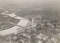 Image 1The city in 1936 (from Columbus, Ohio)
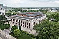


 Image 8Aerial satellite image of Columbus (from Columbus, Ohio)
- Image 9Columbus in 1936 (from History of Columbus, Ohio)
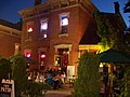 Image 10Brewery District Scene (from Neighborhoods in Columbus, Ohio)

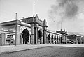
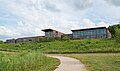 Image 14Audubon nature center at Scioto Audubon Metro Park, the first built close to a major city's downtown (from Columbus, Ohio)
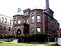 Image 17Home in Old Oaks (from Neighborhoods in Columbus, Ohio)
 Image 18Map of land surveys and city boundary growth, 1812–1920 (from History of Columbus, Ohio)
 Image 19Bird's eye view map of Columbus in 1872 (from History of Columbus, Ohio)
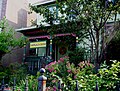 Image 21Historic Home in Harrison West (from Neighborhoods in Columbus, Ohio)
 Image 22Map of the Ohio Country between 1775 and 1794, depicting locations of battles and massacres surrounding the area that would eventually become Ohio (from History of Columbus, Ohio)
 Image 25Big Run Sports Complex, in Big Run Park (from Neighborhoods in Columbus, Ohio)
 Image 26Eastern side of Olentangy Commons (from Neighborhoods in Columbus, Ohio)
 Image 27Barlouie (from Neighborhoods in Columbus, Ohio)
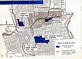 Image 281954 urban renewal map of Columbus (from List of demolished buildings and structures in Columbus, Ohio)
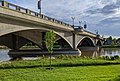

 Image 31COSI (east entrance pictured) features themed, interactive science exhibits. (from Columbus, Ohio)
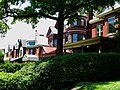 Image 32Victorian-style homes located along Goodale Park (from Neighborhoods in Columbus, Ohio)
 Image 33Municipal offices, including the Columbus Division of Police Headquarters, in the city's Civic Center (from Columbus, Ohio)
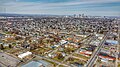 Image 35Aerial view of Reeb-Hosack (from Neighborhoods in Columbus, Ohio)
- Image 37Map of the Ohio Country between 1775 and 1794, depicting locations of battles and massacres surrounding the area that would eventually become the U.S. state of Ohio (from Columbus, Ohio)

- Image 39Bird's eye view map of Columbus in 1872 (from Columbus, Ohio)
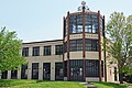

 Image 42Lou Berliner Sports Park (from List of parks in Columbus, Ohio)
 Image 432010 Census-based map: red dots indicate white Americans, blue dots for African Americans, green for Asian Americans, orange for Hispanic Americans, yellow for other races. Each dot represents 25 residents. (from Neighborhoods in Columbus, Ohio)
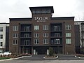 Image 44Taylor House on Bethel Rd. (from Neighborhoods in Columbus, Ohio)
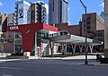
 Image 46Skyline of Columbus (Use cursor to identify buildings) (from List of tallest buildings in Columbus, Ohio)
 Image 47Hilltop signage (from Neighborhoods in Columbus, Ohio)
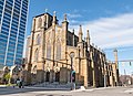

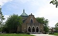 Image 50St. Mary Magdalene Church in Westgate (from Neighborhoods in Columbus, Ohio)
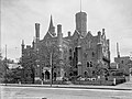
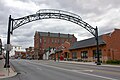 Image 52Old North Columbus Arch (from Neighborhoods in Columbus, Ohio)
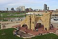
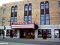 Image 55The historic Lincoln Theatre (from Neighborhoods in Columbus, Ohio)
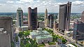 Image 57Four of the city's five tallest buildings are around Capitol Square (from List of tallest buildings in Columbus, Ohio)
 Image 58Camp Chase as it stands today, a memorial to fallen soldiers from the American Civil War. (from Neighborhoods in Columbus, Ohio)
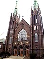 Image 59Holy Rosary and Saint John Church (from Neighborhoods in Columbus, Ohio)
 Image 60The Merion Village arch (from Neighborhoods in Columbus, Ohio)
 Image 61Locations of numbered streets and avenues (from Columbus, Ohio)
 Image 62I-71, part of the innerbelt around downtown, bridged by numerous overpasses (from Columbus, Ohio)
 Image 63Dutch Colonial Style residences in Hungarian Village (from Neighborhoods in Columbus, Ohio)
 Image 64Arcade of the third Union Station, the city's rail station from 1897 to 1977 (from Columbus, Ohio)
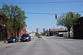
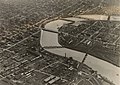 Image 66The city c. 1924 (from History of Columbus, Ohio)
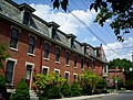 Image 68Italian Village rowhouse (from Neighborhoods in Columbus, Ohio)
 Image 70Hungarian Reform Church, in Hungarian Village (from Neighborhoods in Columbus, Ohio)
 Image 71The Santa Maria Ship & Museum, a Santa María replica, was docked downtown from 1991 to 2014. (from Columbus, Ohio)
- Image 73Racial distribution in Columbus in 2010: ⬤ White ⬤ Black ⬤ Asian ⬤ Hispanic ⬤ Other (from Columbus, Ohio)
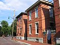 Image 75Homes in German Village (from Neighborhoods in Columbus, Ohio)
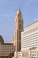 Image 77The LeVeque Tower was the tallest building in Columbus from 1927 to 1973. (from List of tallest buildings in Columbus, Ohio)

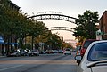 Image 80The iconic arches of the Short North (from Neighborhoods in Columbus, Ohio)


 Image 85Ohio Stadium, on the campus of Ohio State University, is the 5th-largest non-racing stadium in the world. (from Columbus, Ohio)
 Image 87The Pontifical College Josephinum (1888-1931) (from List of demolished buildings and structures in Columbus, Ohio)
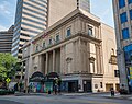
 Image 89The Columbus Museum of Art collects and exhibits American and European modern and contemporary art, folk art, glass art, and photography. (from Columbus, Ohio)
.jpg)


.jpg)


_crop.jpg)


.jpg)


.png)


.jpg)

_-_exterior_2.jpg)


.jpg)


Subcategories

- Select [►] to view subcategories
Subtopics
Associated Wikimedia
The following Wikimedia Foundation sister projects provide more on this subject:
-
 Commons
Free media repository -
 Wikibooks
Free textbooks and manuals -
 Wikidata
Free knowledge base -
 Wikinews
Free-content news -
 Wikiquote
Collection of quotations -
 Wikisource
Free-content library -
 Wikiversity
Free learning tools -
 Wiktionary
Dictionary and thesaurus
- What are portals?
- List of portals
Category:United States portals by city Category:Portals needing placement of incoming links