File:Wellington_landsat_labelled.jpg
From Wikipedia, the free encyclopedia
Size of this preview: 800 × 593 pixels. Other resolutions: 320 × 237 pixels | 640 × 474 pixels | 1,024 × 758 pixels | 1,280 × 948 pixels.
Original file (1,280 × 948 pixels, file size: 206 KB, MIME type: image/jpeg)
| This is a file from the Wikimedia Commons. Information from its description page there is shown below. Commons is a freely licensed media file repository. You can help. |
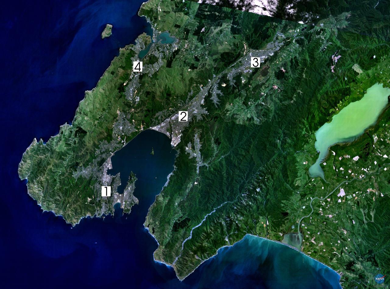
| DescriptionWellington landsat labelled.jpg |
NASA World Wind composite landsat-7 satellite image of Wellington, New Zealand. (1) Central Wellington (2) Lower Hutt (3) Upper Hutt (4) Porirua. English: Satellite photo of the Wellington conurbation: (1) Wellington; (2) Lower Hutt; (3) Upper Hutt; (4) Porirua.
日本語: 人工衛星によるウェリントンの写真。1: ウェリントン、2: ロウワー・ハット (Lower Hutt)、3: アッパー・ハット (Upper Hutt)、4: ポリルア (Porirua)。以上の4市がウェリントン都市圏 (urban area) を構成する
Norsk bokmål: Satelittfoto av Wellingtonregionen. (1) Wellington (2) Lower Hutt (3) Upper Hutt (4) Porirua |
||||
| Source | en:wikipedia | ||||
| Author | NASA, edited by en:User:Clawed | ||||
| Permission (Reusing this file) |
|

File history
Click on a date/time to view the file as it appeared at that time.
| Date/Time | Thumbnail | Dimensions | User | Comment | |
|---|---|---|---|---|---|
| current | 16:34, 1 September 2005 | | 1,280 × 948 (206 KB) | Klipp~commonswiki | NASA World Wind composite landsat-7 satellite image of Wellington, New Zealand. (1) Central Wellington (2) Lower Hutt (3) Upper Hutt (4) Porirua. {{PD-USGov-NASA}} |
File usage
The following pages on the English Wikipedia use this file (pages on other projects are not listed):
- Hutt Valley
- Lake Wairarapa
- Wellington Region
- User:CatholicKiwi
- User:Joseph Pelorus
- User:Ollieinc/Userboxes
- User:Ollieinc/Userboxes/Wider Wellington
- User:Ollieinc/Userboxes/hasWider Wellington
- User:WG at Dole
- Wikipedia:Userboxes/Location/New Zealand
- Wikipedia:Wikipedians in New Zealand user boxes
- Category:Wikipedians in New Zealand
Global file usage
The following other wikis use this file:
- Usage on ast.wikipedia.org
- Usage on ca.wikipedia.org
- Usage on da.wikipedia.org
- Usage on de.wikipedia.org
- Usage on el.wikipedia.org
- Usage on eo.wikipedia.org
- Usage on es.wikipedia.org
- Usage on fr.wikipedia.org
- Usage on gl.wikipedia.org
- Usage on hu.wikipedia.org
- Usage on ja.wikipedia.org
- Usage on mi.wikipedia.org
- Usage on nn.wikipedia.org
- Usage on no.wikipedia.org
- Usage on pl.wikipedia.org
- Usage on pt.wikipedia.org
- Usage on sv.wikipedia.org
- Usage on tr.wikipedia.org
- Usage on uk.wikipedia.org
- Usage on www.wikidata.org
- Usage on zh.wikipedia.org
Metadata
This file contains additional information, probably added from the digital camera or scanner used to create or digitize it.
If the file has been modified from its original state, some details may not fully reflect the modified file.
| _error | 0 |
|---|
Retrieved from "https://en.wikipedia.org/wiki/File:Wellington_landsat_labelled.jpg"