File:Waverley_Line_1969.png
From Wikipedia, the free encyclopedia
Size of this preview: 260 × 600 pixels. Other resolutions: 104 × 240 pixels | 208 × 480 pixels | 333 × 768 pixels | 444 × 1,024 pixels | 2,234 × 5,153 pixels.
Original file (2,234 × 5,153 pixels, file size: 6.02 MB, MIME type: image/png)
| This is a file from the Wikimedia Commons. Information from its description page there is shown below. Commons is a freely licensed media file repository. You can help. |
Summary
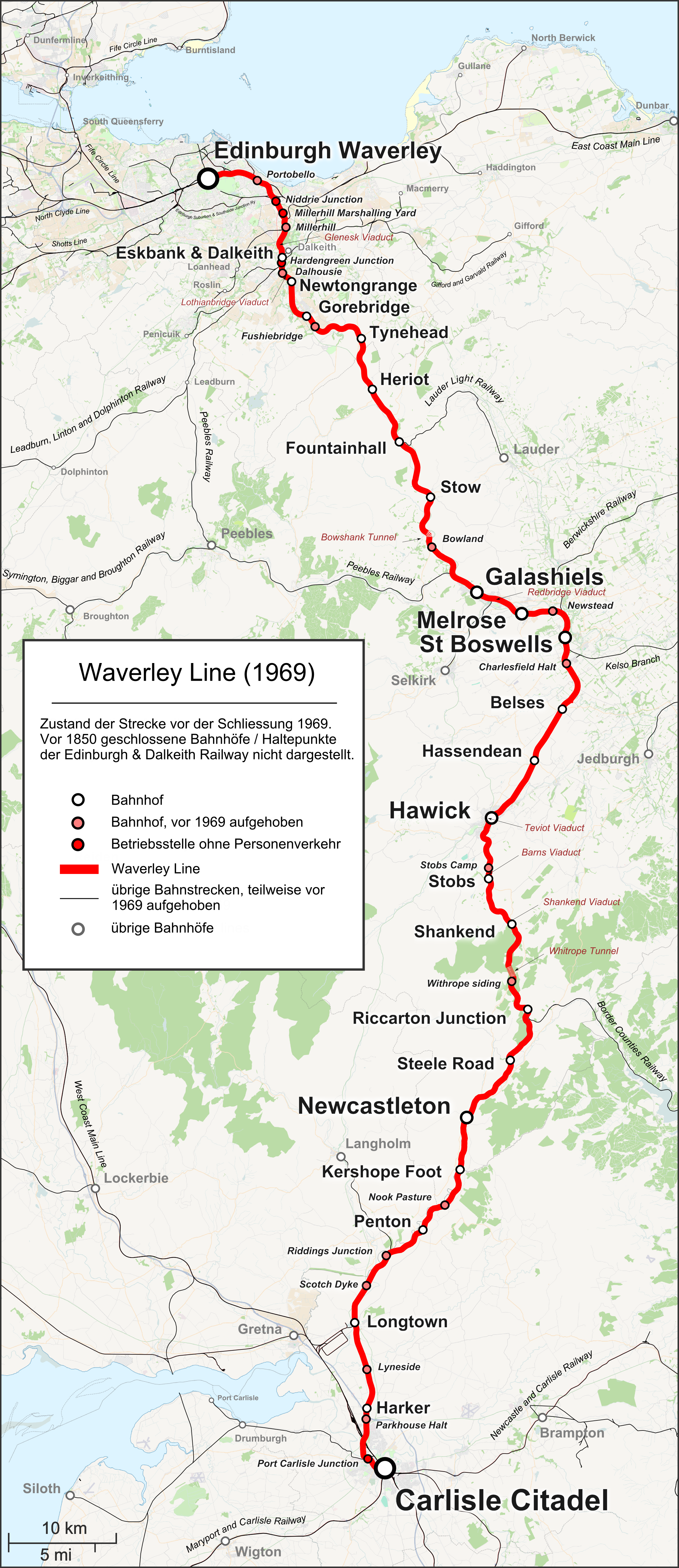
| DescriptionWaverley Line 1969.png |
Deutsch: Karte der Waverley Line vor der Schließung 1969.
English: Map of the Waverley Line in Scotland, as it was before closure in 1969. Caption in German. |
| Date | |
| Source |
|
| Author | |
| Permission (Reusing this file) |
Map data (c) OpenStreetMap (and) contributors, CC-BY-SA |
| Other versions |
|


Licensing
This file is licensed under the Creative Commons Attribution-Share Alike 2.0 Generic license.
- You are free:
- to share – to copy, distribute and transmit the work
- to remix – to adapt the work
- Under the following conditions:
- attribution – You must give appropriate credit, provide a link to the license, and indicate if changes were made. You may do so in any reasonable manner, but not in any way that suggests the licensor endorses you or your use.
- share alike – If you remix, transform, or build upon the material, you must distribute your contributions under the same or compatible license as the original.
Captions
Add a one-line explanation of what this file represents
Items portrayed in this file
depicts
some value
31 December 2014
image/png
File history
Click on a date/time to view the file as it appeared at that time.
| Date/Time | Thumbnail | Dimensions | User | Comment | |
|---|---|---|---|---|---|
| current | 14:20, 15 September 2018 | | 2,234 × 5,153 (6.02 MB) | Pechristener | Fife Circle Line instead of Five Circle Line |
| 21:14, 23 March 2015 |  | 2,234 × 5,153 (6.08 MB) | Pechristener | Rechtschreibung angepasst | |
| 20:12, 9 March 2015 |  | 2,234 × 5,153 (6.08 MB) | Pechristener | Update gemäss Review Verkehr | |
| 03:02, 3 January 2015 |  | 2,234 × 5,153 (6.08 MB) | Pechristener | update gemäss KW | |
| 12:12, 31 December 2014 |  | 2,234 × 5,153 (4.53 MB) | Pechristener | updated index title | |
| 11:45, 31 December 2014 |  | 2,234 × 5,153 (4.52 MB) | Pechristener | {{Information |Description={{en|Map of the en:Waverley Line in Scotland, as it was before closure in 1969.}} |Source=*{{own}}, map was created using [http://www.openstreetmap.org/ Open Street Map] |Date=2014-12-31 |Author=*[[User:Pechristener|Pech... |
File usage
No pages on the English Wikipedia use this file (pages on other projects are not listed).
Global file usage
The following other wikis use this file:
- Usage on de.wikipedia.org
- Usage on www.wikidata.org
Metadata
This file contains additional information, probably added from the digital camera or scanner used to create or digitize it.
If the file has been modified from its original state, some details may not fully reflect the modified file.
| Horizontal resolution | 27.56 dpc |
|---|---|
| Vertical resolution | 27.56 dpc |
| Software used |
Retrieved from "https://en.wikipedia.org/wiki/File:Waverley_Line_1969.png"