File:WW2_Holocaust_Europe_map-de.png
From Wikipedia, the free encyclopedia
Size of this preview: 721 × 600 pixels. Other resolutions: 289 × 240 pixels | 577 × 480 pixels | 923 × 768 pixels | 1,231 × 1,024 pixels | 2,461 × 2,048 pixels | 2,729 × 2,271 pixels.
Original file (2,729 × 2,271 pixels, file size: 660 KB, MIME type: image/png)
| This is a file from the Wikimedia Commons. Information from its description page there is shown below. Commons is a freely licensed media file repository. You can help. |
Summary
| DescriptionWW2 Holocaust Europe map-de.png |
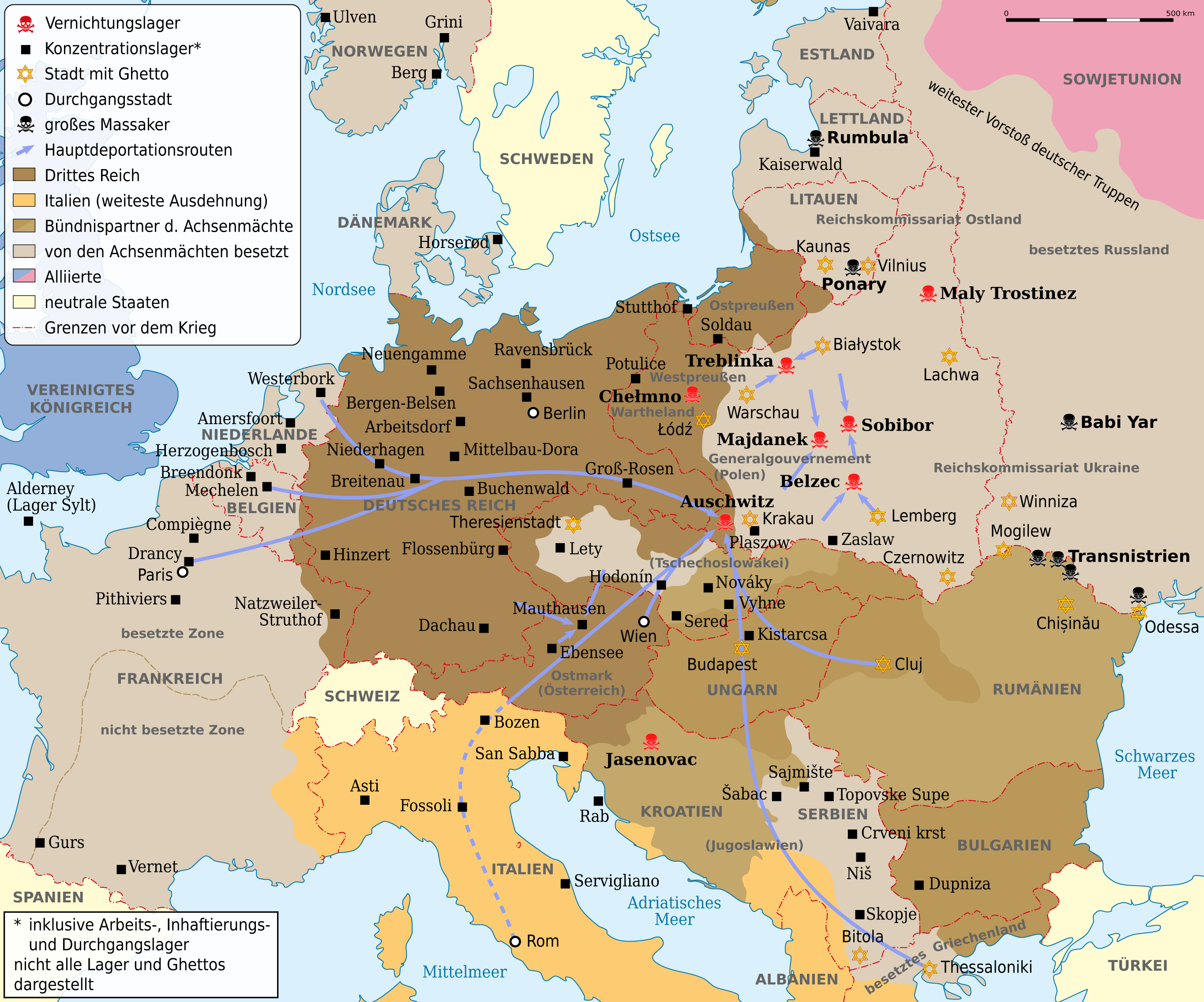
Deutsch: Karte der Vernichtungslager, der meisten großen Konzentrationslager (Arbeits-, Inhaftierungs- und Durchgangslager), der Hauptdeportationsrouten, Ghettos und Orten großer Massaker. Grenzen etwa 1942. Vor- und Nachkriegsstaatennamen in Klammern. English: Map of the extermination camps, most of the major concentration camps (labor, detention and transit camp), the main deportation routes, ghettos and places great massacre. Limits about the 1942nd Pre-and post-conflict states name in parentheses |
| Date | |
| Source |
This file was derived from: WW2 Holocaust Europe map-fr.svg |
| Author |
|
| This is a retouched picture, which means that it has been digitally altered from its original version. Modifications: translation. The original can be viewed here: WW2 Holocaust Europe map-fr.svg:
|
Licensing
I, the copyright holder of this work, hereby publish it under the following license:
| Copyleft: This work of art is free; you can redistribute it and/or modify it according to terms of the Free Art License. You will find a specimen of this license on the Copyleft Attitude site as well as on other sites. http://artlibre.org/licence/lal/enFALFree Art Licensefalsetrue |
Original upload log
This image is a derivative work of the following images:
- File:WW2_Holocaust_Europe_map-fr.svg licensed with FAL
- 2011-09-28T13:32:55Z Sémhur 1310x1090 (502755 Bytes) Location of Varsovie, border between Poland and East Prussia
- 2009-05-11T16:52:07Z Sémhur 1310x1090 (607330 Bytes) {{Information |Description=Map of the Holocaust in Europe during World War II, 1939-1945. This map shows all extermination camps (or ''death camps''), most major concentration camps, labor camps, prison camps, ghettos, major
Captions
Add a one-line explanation of what this file represents
Karte der Vernichtungslager, der meisten großen Konzentrationslager (Arbeits-, Inhaftierungs- und Durchgangslager), der Hauptdeportationsrouten, Ghettos und Orten großer Massaker. Grenzen etwa 1942.
12 September 2012
File history
Click on a date/time to view the file as it appeared at that time.
| Date/Time | Thumbnail | Dimensions | User | Comment | |
|---|---|---|---|---|---|
| current | 08:53, 1 May 2013 | | 2,729 × 2,271 (660 KB) | NordNordWest | c |
| 08:03, 14 September 2012 |  | 2,729 × 2,271 (660 KB) | NordNordWest | c | |
| 20:45, 13 September 2012 |  | 2,729 × 2,271 (654 KB) | NordNordWest | c | |
| 19:07, 12 September 2012 |  | 2,729 × 2,271 (660 KB) | NordNordWest | == {{int:filedesc}} == {{Information |Description={{de|Karte der Vernichtungslager, der meisten großen Konzentrationslager (Arbeits-, Inhaftierungs- und Durchgangslager), der Hauptdeportationsrouten, Ghettos und Orten großer Massaker. Grenzen etwa 19... |
File usage
No pages on the English Wikipedia use this file (pages on other projects are not listed).
Global file usage
The following other wikis use this file:
- Usage on ca.wikipedia.org
- Usage on de.wikipedia.org
- Deportation
- Holocaust
- Durchgangslager Fossoli
- Deutsche Besetzung Polens 1939–1945
- Konzentrationslager
- Durchgangslager Bozen
- Eichmannreferat
- Wikipedia:Kartenwerkstatt/Archiv/2012-09
- Deutsche Besetzung Frankreichs im Zweiten Weltkrieg
- Diskussion:Gesetz über das Institut des Nationalen Gedenkens – Kommission für die Verfolgung von Verbrechen gegen das Polnische Volk
- Usage on ga.wikipedia.org
- Usage on ksh.wikipedia.org
- Usage on no.wikipedia.org
- Usage on stq.wikipedia.org
- Usage on uk.wikipedia.org
- Usage on www.wikidata.org
Metadata
This file contains additional information, probably added from the digital camera or scanner used to create or digitize it.
If the file has been modified from its original state, some details may not fully reflect the modified file.
| Horizontal resolution | 59.06 dpc |
|---|---|
| Vertical resolution | 59.06 dpc |
| Software used |
Retrieved from "https://en.wikipedia.org/wiki/File:WW2_Holocaust_Europe_map-de.png"