File:Virginia_map_1606.jpg
From Wikipedia, the free encyclopedia
Size of this preview: 775 × 600 pixels. Other resolutions: 310 × 240 pixels | 620 × 480 pixels | 992 × 768 pixels | 1,280 × 991 pixels | 2,560 × 1,981 pixels | 3,500 × 2,709 pixels.
Original file (3,500 × 2,709 pixels, file size: 6.05 MB, MIME type: image/jpeg)
| This is a file from the Wikimedia Commons. Information from its description page there is shown below. Commons is a freely licensed media file repository. You can help. |
| DescriptionVirginia map 1606.jpg |
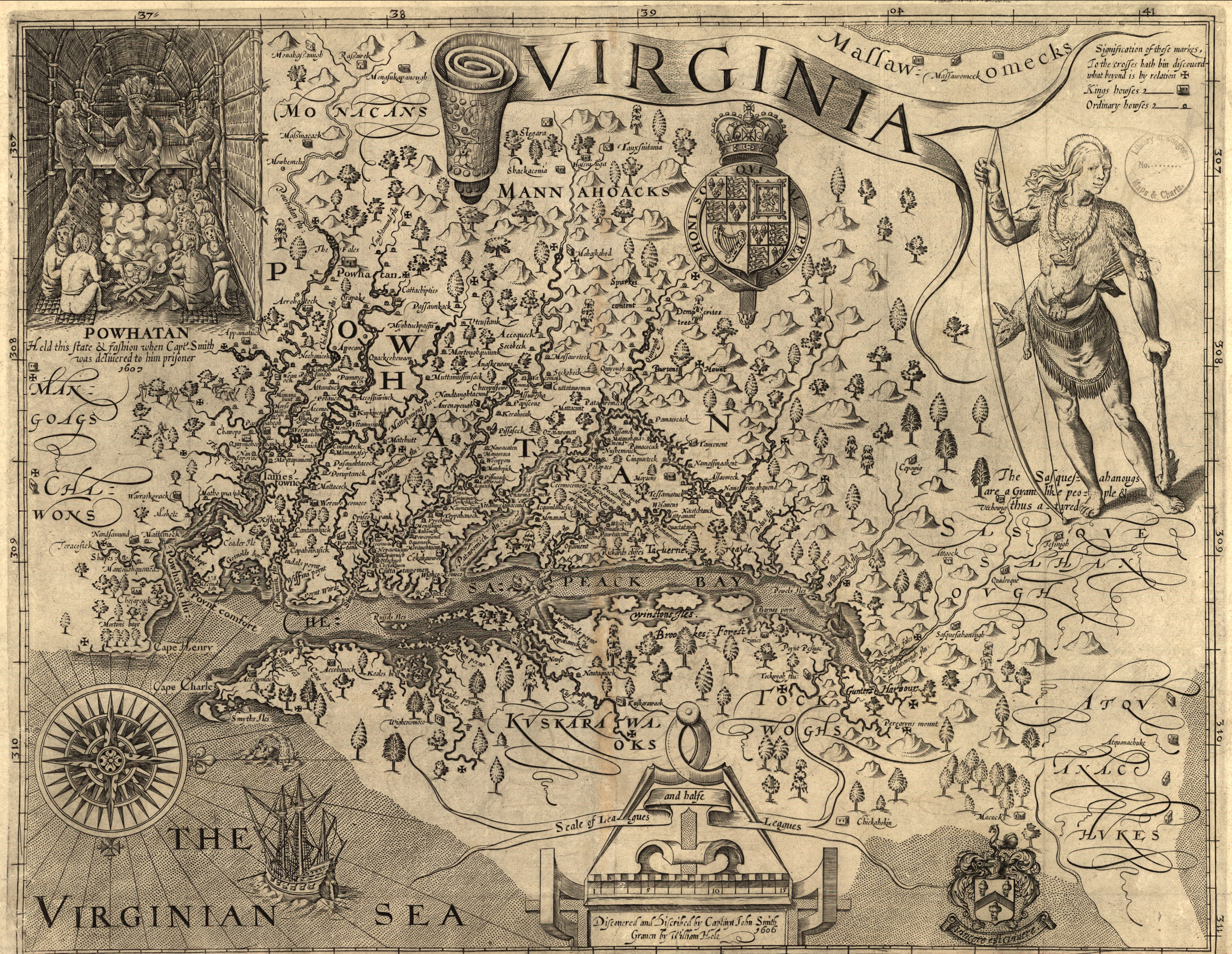
English: Map of Virginia, discovered and as described by Captain John Smith, 1606; engraved by William Hole. Map created in 1606. |
| Date | |
| Source | Library of Congress |
| Author | engraved by William Hole |
| Permission (Reusing this file) |
No known restrictions on publication. |
| Other versions |
|

Licensing
| Public domainPublic domainfalsefalse |
|
This work is in the public domain in its country of origin and other countries and areas where the copyright term is the author's life plus 100 years or fewer. | |
| This file has been identified as being free of known restrictions under copyright law, including all related and neighboring rights. | |
https://creativecommons.org/publicdomain/mark/1.0/PDMCreative Commons Public Domain Mark 1.0falsefalse
| Annotations InfoField | This image is annotated: View the annotations at Commons |
334
212
135
321
3500
2709
Powhatan (Native American leader)
Captions
Add a one-line explanation of what this file represents
Items portrayed in this file
depicts
image/jpeg
File history
Click on a date/time to view the file as it appeared at that time.
| Date/Time | Thumbnail | Dimensions | User | Comment | |
|---|---|---|---|---|---|
| current | 16:07, 17 March 2011 | | 3,500 × 2,709 (6.05 MB) | Patrickneil | Leveling and color correction |
| 19:06, 18 January 2007 |  | 3,500 × 2,709 (6 MB) | Aude | ||
| 19:04, 18 January 2007 |  | 4,970 × 3,847 (10.45 MB) | Aude | ||
| 19:01, 18 January 2007 |  | 5,733 × 3,854 (16.12 MB) | Aude | Map of Virginia, discovered and as described by Captain John Smith, 1606; engraven by William Hole. Map created in 1606. Source: Library of Congress |
File usage
The following pages on the English Wikipedia use this file (pages on other projects are not listed):
Global file usage
The following other wikis use this file:
- Usage on cs.wikipedia.org
- Usage on de.wikipedia.org
- Usage on eo.wikipedia.org
- Usage on es.wikipedia.org
- Usage on hr.wiktionary.org
- Usage on is.wikipedia.org
- Usage on ja.wikipedia.org
- Usage on ko.wikipedia.org
Metadata
This file contains additional information, probably added from the digital camera or scanner used to create or digitize it.
If the file has been modified from its original state, some details may not fully reflect the modified file.
| Width | 3,500 px |
|---|---|
| Height | 2,709 px |
| Pixel composition | RGB |
| Orientation | Normal |
| Number of components | 3 |
| Horizontal resolution | 72 dpi |
| Vertical resolution | 72 dpi |
| Software used | Adobe Photoshop CS5 Windows |
| File change date and time | 12:06, 17 March 2011 |
| Exif version | 2.21 |
| Color space | Uncalibrated |
Retrieved from "https://en.wikipedia.org/wiki/File:Virginia_map_1606.jpg"