File:Vanuatu-Hiw-Toponymic.png
From Wikipedia, the free encyclopedia
Size of this preview: 623 × 599 pixels. Other resolutions: 250 × 240 pixels | 499 × 480 pixels | 763 × 734 pixels.
Original file (763 × 734 pixels, file size: 94 KB, MIME type: image/png)
| This is a file from the Wikimedia Commons. Information from its description page there is shown below. Commons is a freely licensed media file repository. You can help. |
Summary
| DescriptionVanuatu-Hiw-Toponymic.png |
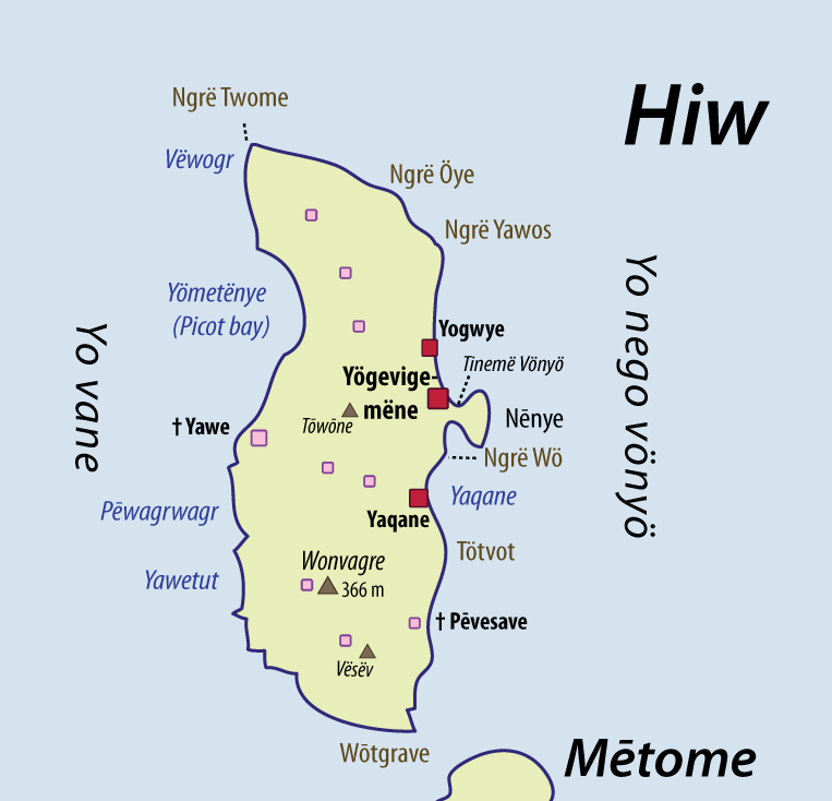
English: This map of Hiw (Torres Islands) shows some of the place names which are used by the local population, in Hiw. I have collected these place names while I was doing linguistic fieldwork in these islands. The spelling chosen here is a compromise between local phonologies/orthographies, and Western keyboards or usages. I would personally encourage the use of these transcriptions in further toponymic work on this area; except perhaps for the island names, which have been known under slightly different transcriptions in the literature. See Discussion page for further issues (spelling, etc). Red dots = inhabited villages; Pink dots = ancient villages, now deserted. |
| Date | |
| Source | Own work |
| Author | Alexandre François |
| Other versions | File:Vanuatu-Torres-islands-Toponymic.png |
Licensing
I, the copyright holder of this work, hereby publish it under the following licenses:

|
Permission is granted to copy, distribute and/or modify this document under the terms of the GNU Free Documentation License, Version 1.2 or any later version published by the Free Software Foundation; with no Invariant Sections, no Front-Cover Texts, and no Back-Cover Texts. A copy of the license is included in the section entitled GNU Free Documentation License.http://www.gnu.org/copyleft/fdl.htmlGFDLGNU Free Documentation Licensetruetrue |
This file is licensed under the Creative Commons Attribution 3.0 Unported license.
- You are free:
- to share – to copy, distribute and transmit the work
- to remix – to adapt the work
- Under the following conditions:
- attribution – You must give appropriate credit, provide a link to the license, and indicate if changes were made. You may do so in any reasonable manner, but not in any way that suggests the licensor endorses you or your use.
You may select the license of your choice.
Captions
Add a one-line explanation of what this file represents
Items portrayed in this file
depicts
24 November 2010
File history
Click on a date/time to view the file as it appeared at that time.
| Date/Time | Thumbnail | Dimensions | User | Comment | |
|---|---|---|---|---|---|
| current | 05:05, 24 November 2010 | | 763 × 734 (94 KB) | Womtelo | {{Information |Description={{en|1=This map of Hiw (Torres Islands) shows some of the place names which are used by the local population, in Hiw. I have collected these place names while I was doing linguistic fieldwork in these islands. The spelling chose |
File usage
The following pages on the English Wikipedia use this file (pages on other projects are not listed):
Global file usage
The following other wikis use this file:
- Usage on arz.wikipedia.org
- Usage on bi.wikipedia.org
- Usage on de.wikipedia.org
- Usage on en.wiktionary.org
- Usage on eo.wikipedia.org
- Usage on fr.wikipedia.org
- Usage on gl.wikipedia.org
- Usage on it.wikipedia.org
- Usage on ja.wikipedia.org
- Usage on mrj.wikipedia.org
- Usage on nl.wikipedia.org
- Usage on uk.wikipedia.org
- Usage on www.wikidata.org
- Usage on zh.wikipedia.org
Retrieved from "https://en.wikipedia.org/wiki/File:Vanuatu-Hiw-Toponymic.png"