File:USSR_Republics_Numbered_Alphabetically.png
From Wikipedia, the free encyclopedia
Original file (1,356 × 928 pixels, file size: 80 KB, MIME type: image/png)
| This is a file from the Wikimedia Commons. Information from its description page there is shown below. Commons is a freely licensed media file repository. You can help. |

|
File:USSR Republics numbered by alphabet.svg is a vector version of this file. It should be used in place of this PNG file when not inferior.
File:USSR Republics Numbered Alphabetically.png → File:USSR Republics numbered by alphabet.svg
For more information, see Help:SVG.
|
 |
Summary
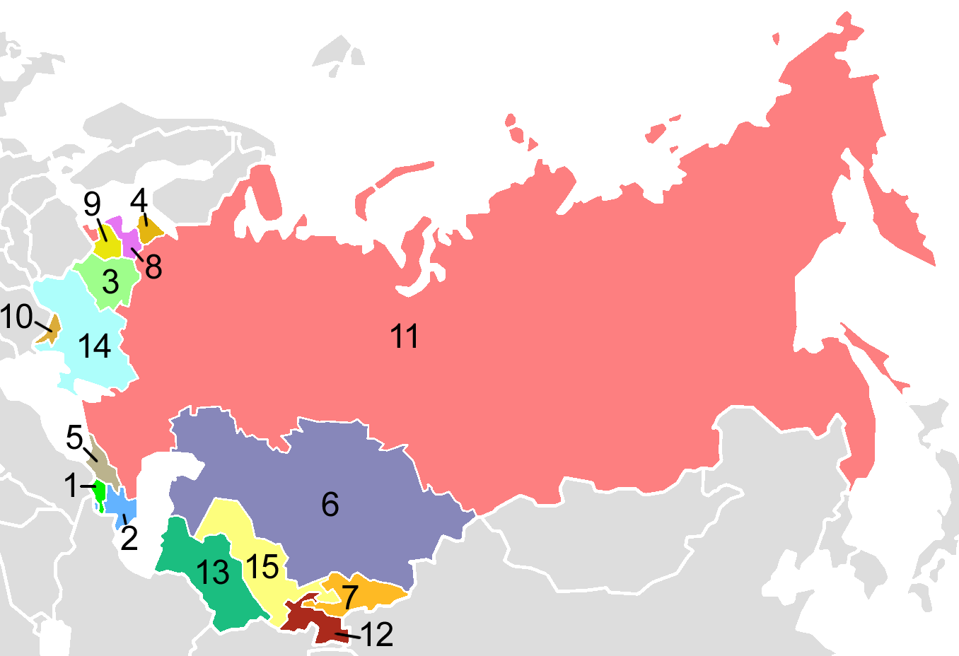
USSR Republics, numbered alphabetically.
Post-Soviet states in English alphabetical order:
| 1. | Armenia |
| 2. | Azerbaijan |
| 3. | Belarus |
| 4. | Estonia |
| 5. | Georgia |
| 6. | Kazakhstan |
| 7. | Kyrgyzstan |
| 8. | Latvia |
| 9. | Lithuania |
| 10. | Moldova |
| 11. | Russia |
| 12. | Tajikistan |
| 13. | Turkmenistan |
| 14. | Ukraine |
| 15. | Uzbekistan |
Map created by en:User:Aris_Katsaris, based on Image:Soviet Union Map.png in mimicry of the concept of fr:Image:USSR_Republics_Numbered_Alphabetically.png.
Licensing
| Public domainPublic domainfalsefalse |
| This map is ineligible for copyright and therefore in the public domain, because it consists entirely of information that is common property and contains no original authorship. For more information, see Commons:Threshold of originality § Maps.
English | Español | Galego | Română | slovenščina | العربية | 简体中文 | 繁體中文 | +/− |
Derivative works
Derivative works of this file: Soviet Socialist Republics numbered by the Soviet constitution.png
| Annotations InfoField | This image is annotated: View the annotations at Commons |
Carte de l'Union des Républiques Socialistes Soviétiques
Captions
Items portrayed in this file
depicts
image/png
File history
Click on a date/time to view the file as it appeared at that time.
| Date/Time | Thumbnail | Dimensions | User | Comment | |
|---|---|---|---|---|---|
| current | 03:40, 3 August 2009 | | 1,356 × 928 (80 KB) | Hoshie | Added border for N. Ireland; spilit Germany so that this map dates from 1988-89 |
| 21:06, 10 October 2008 |  | 1,356 × 928 (52 KB) | Milosevo | {{Information |Description= |Source= |Date= |Author= |Permission= |other_versions= }} | |
| 03:38, 15 April 2005 |  | 1,356 × 928 (46 KB) | Aris Katsaris | USSR Republics, numbered alphabetically. Created by User:Aris Katsaris, based on Image:Soviet Union Map.png, in mimicry of the concept of en:Image:Soviet republics.jpg. {{GFDL}} Category:Political divisions of the Soviet Union [[Categor |
File usage
Global file usage
The following other wikis use this file:
- Usage on af.wikipedia.org
- Usage on als.wikipedia.org
- Usage on ar.wikipedia.org
- Usage on ast.wikipedia.org
- Usage on avk.wikipedia.org
- Usage on azb.wikipedia.org
- Usage on ban.wikipedia.org
- Usage on bar.wikipedia.org
- Usage on be-tarask.wikipedia.org
- Usage on bg.wikipedia.org
- Usage on br.wikipedia.org
- Usage on bs.wikipedia.org
- Usage on ca.wikipedia.org
- Usage on ckb.wikipedia.org
- Usage on cs.wikipedia.org
- Usage on cv.wikipedia.org
- Usage on cy.wikipedia.org
- Usage on da.wikipedia.org
- Sovjetunionen
- Bruger:Rasmus81/Sandkasse2
- Jødiske autonome oblast
- Russiske SFSR
- Sovjetrepublik
- Karelsk-finske SSR
- Lettiske SSR
- Aserbajdsjanske SSR
- Skabelon:Navboks Sovjetunionens administrative inddeling
- Hviderussiske SSR
- Ukrainske SSR
- Karelske ASSR
- Litauiske SSR
- Estiske SSR
- Autonome Socialistiske Sovjetrepublikker i Sovjetunionen
- SNG ved OL
- Tadsjikiske SSR
- Georgiske SSR
View more global usage of this file.
Metadata
This file contains additional information, probably added from the digital camera or scanner used to create or digitize it.
If the file has been modified from its original state, some details may not fully reflect the modified file.
| File change date and time | 21:05, 10 October 2008 |
|---|