File:Txu-pclmaps-topo-us-saint_lawrence-1970.jpg
From Wikipedia, the free encyclopedia
Size of this preview: 778 × 599 pixels. Other resolutions: 312 × 240 pixels | 623 × 480 pixels | 997 × 768 pixels | 1,280 × 986 pixels | 2,560 × 1,972 pixels | 5,957 × 4,589 pixels.
Original file (5,957 × 4,589 pixels, file size: 4.29 MB, MIME type: image/jpeg)
| This is a file from the Wikimedia Commons. Information from its description page there is shown below. Commons is a freely licensed media file repository. You can help. |
Summary
| DescriptionTxu-pclmaps-topo-us-saint lawrence-1970.jpg |
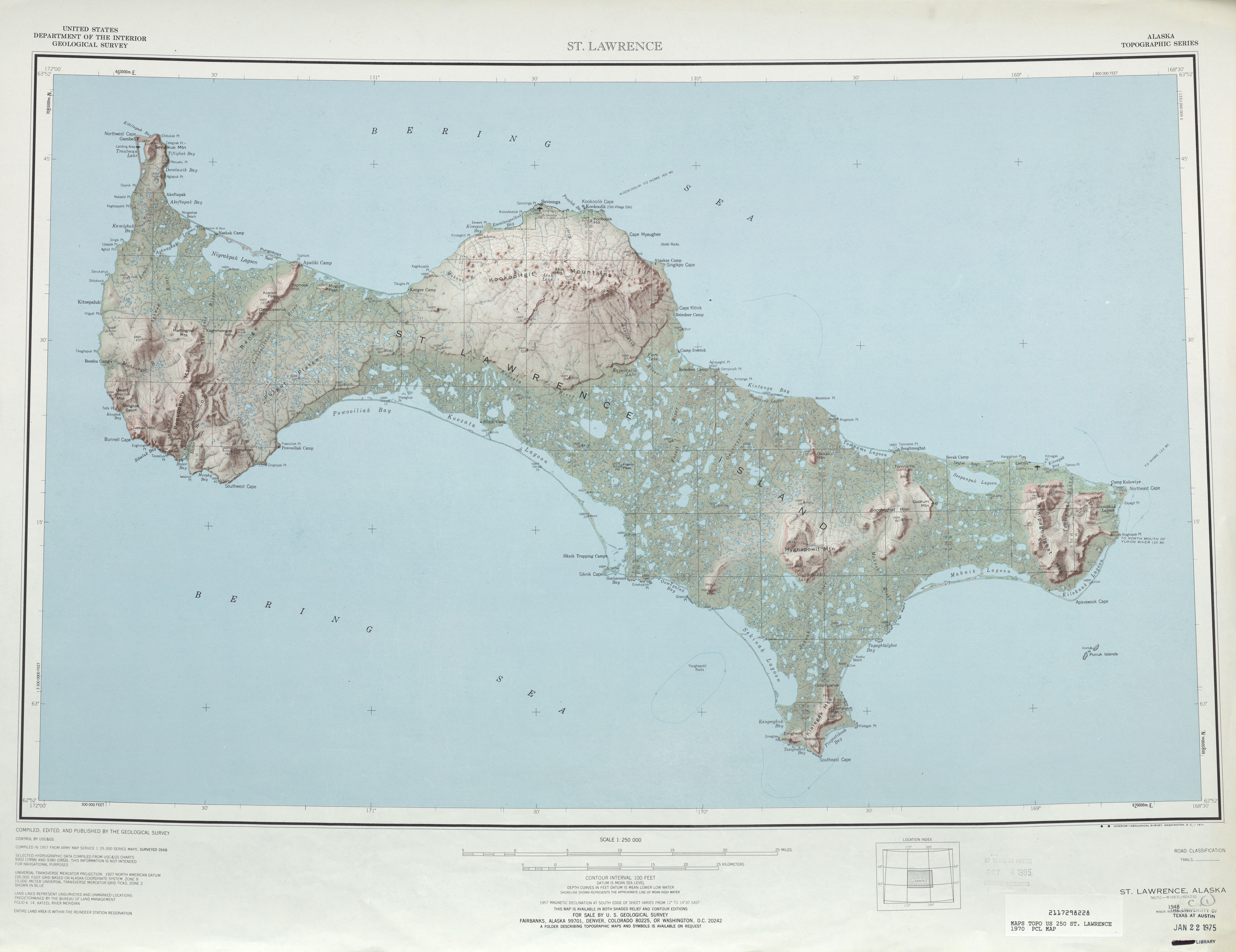
English: map sheet of Saint Lawrence Island, Alaska |
|||
| Date | ||||
| Source | http://www.lib.utexas.edu/maps/topo/250k/txu-pclmaps-topo-us-saint_lawrence-1970.jpg | |||
| Author | US Geological Survey | |||
| Other versions |
|
.jpg)
Licensing
| Public domainPublic domainfalsefalse |
This image is in the public domain in the United States because it only contains materials that originally came from the United States Geological Survey, an agency of the United States Department of the Interior. For more information, see the official USGS copyright policy.
Bahasa Indonesia ∙ català ∙ čeština ∙ Deutsch ∙ eesti ∙ English ∙ español ∙ français ∙ galego ∙ italiano ∙ Nederlands ∙ português ∙ polski ∙ sicilianu ∙ suomi ∙ Tiếng Việt ∙ Türkçe ∙ български ∙ македонски ∙ русский ∙ മലയാളം ∙ 한국어 ∙ 日本語 ∙ 中文 ∙ 中文(简体) ∙ 中文(繁體) ∙ العربية ∙ فارسی ∙ +/− |
Captions
Add a one-line explanation of what this file represents
Items portrayed in this file
depicts
1970
File history
Click on a date/time to view the file as it appeared at that time.
| Date/Time | Thumbnail | Dimensions | User | Comment | |
|---|---|---|---|---|---|
| current | 21:45, 1 October 2010 | | 5,957 × 4,589 (4.29 MB) | Ratzer | {{Information |Description={{en|1=map sheet of Saint Lawrence Island, Alaska}} |Source=http://www.lib.utexas.edu/maps/topo/250k/txu-pclmaps-topo-us-saint_lawrence-1970.jpg |Author=US Geological Survey |Date=1970 |Permission= |other_versions= }} [[Categor |
File usage
The following pages on the English Wikipedia use this file (pages on other projects are not listed):
Global file usage
The following other wikis use this file:
- Usage on ar.wikipedia.org
- Usage on be.wikipedia.org
- Usage on bg.wikipedia.org
- Usage on ca.wikipedia.org
- Usage on ceb.wikipedia.org
- Usage on cs.wikipedia.org
- Usage on da.wikipedia.org
- Usage on de.wikipedia.org
- Usage on el.wikipedia.org
- Usage on eo.wikipedia.org
- Usage on es.wikipedia.org
- Usage on eu.wikipedia.org
- Usage on fa.wikipedia.org
- Usage on fr.wikipedia.org
- Usage on fy.wikipedia.org
- Usage on he.wikipedia.org
- Usage on id.wikipedia.org
- Usage on incubator.wikimedia.org
- Usage on it.wikipedia.org
- Usage on ja.wikipedia.org
- Usage on no.wikipedia.org
- Usage on pl.wikipedia.org
- Usage on ru.wikipedia.org
- Usage on sco.wikipedia.org
- Usage on simple.wikipedia.org
- Usage on th.wikipedia.org
- Usage on www.wikidata.org
- Usage on zh.wikipedia.org
Metadata
This file contains additional information, probably added from the digital camera or scanner used to create or digitize it.
If the file has been modified from its original state, some details may not fully reflect the modified file.
| Camera manufacturer | i2s Digibook Scanner |
|---|---|
| Camera model | Suprascan A0 10000 RGB |
| Width | 11,913 px |
| Height | 9,177 px |
| Compression scheme | Uncompressed |
| Pixel composition | RGB |
| Orientation | Normal |
| Number of components | 3 |
| Horizontal resolution | 200 dpi |
| Vertical resolution | 200 dpi |
| Data arrangement | chunky format |
| Software used | Adobe Photoshop CS2 Macintosh |
| File change date and time | 12:46, 23 August 2007 |
| Color space | Uncalibrated |