File:Turbid_Waters_Surround_New_Zealand.jpg
From Wikipedia, the free encyclopedia
Size of this preview: 507 × 599 pixels. Other resolutions: 203 × 240 pixels | 406 × 480 pixels | 650 × 768 pixels | 866 × 1,024 pixels | 1,732 × 2,048 pixels | 5,582 × 6,599 pixels.
Original file (5,582 × 6,599 pixels, file size: 16.31 MB, MIME type: image/jpeg)
| This is a file from the Wikimedia Commons. Information from its description page there is shown below. Commons is a freely licensed media file repository. You can help. |
Summary
| DescriptionTurbid Waters Surround New Zealand.jpg |
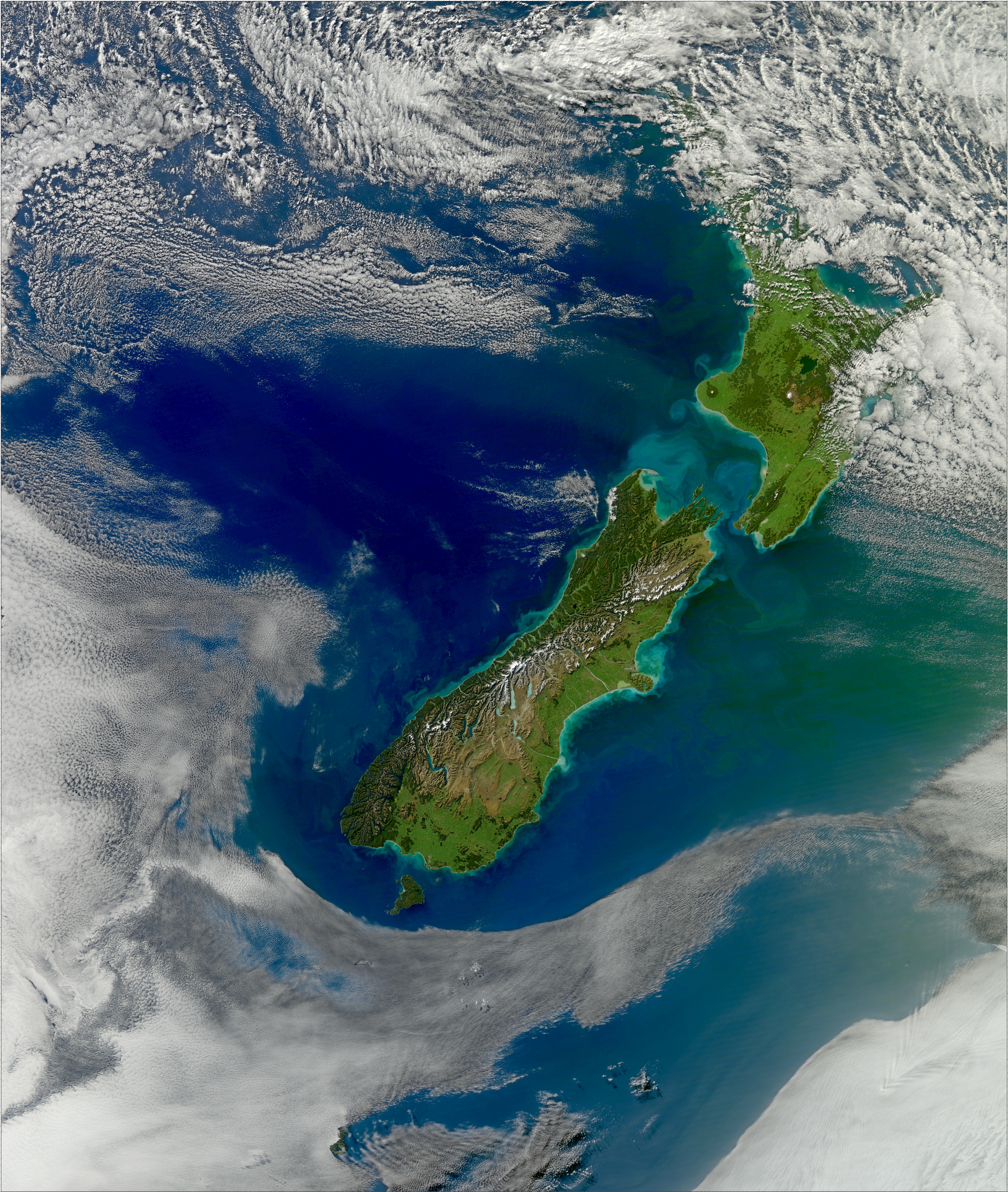
English: View of sediment from New Zealand flowing in the Pacific Ocean. The volume of sediment in the water hints at rough seas. Distinctive plumes arise from pulsing rivers, while the halo of turquoise around both islands is likely sediment swept up to the ocean surface by powerful waves. The plumes fan out and fade from tan to green and blue with water depth and distance from the shore. The Cook Strait, the narrow strip of water separating the North and South Islands of New Zealand, has a reputation for being among the world’s roughest stretches of water. The islands lie within the “Roaring Forties,” a belt of winds that circles the globe around 40 degrees south. The westerlies hit the islands side on and run into the mountain ranges. The Cook Strait is the only opening for the winds, so the channel becomes something of a wind tunnel. Strong winds produce high waves, and they erode the shore as shown in the image. |
| Date | |
| Source | NASA Earth Observatory |
| Author | Norman Kuring |
Image captured by the Moderate Resolution Imaging Spectroradiometer (MODIS) on NASA’s Aqua satellite.
Licensing
| Public domainPublic domainfalsefalse |
| This image is in the public domain because it is a screenshot from NASA’s globe software World Wind using a public domain layer, such as Blue Marble, MODIS, Landsat, SRTM, USGS or GLOBE.
العربيَّة | English | فارسی | français | עברית | македонски | മലയാളം | Nederlands | русский | 中文(中国大陆) | +/− |
 |
| Annotations InfoField | This image is annotated: View the annotations at Commons |
4118
2082
165
165
5582
6599
North Island
3314
3107
154
154
5582
6599
South Island
3997
2831
88
88
5582
6599
Cook Strait
Captions
Add a one-line explanation of what this file represents
Items portrayed in this file
depicts
29 April 2011
File history
Click on a date/time to view the file as it appeared at that time.
| Date/Time | Thumbnail | Dimensions | User | Comment | |
|---|---|---|---|---|---|
| current | 10:02, 26 May 2011 | | 5,582 × 6,599 (16.31 MB) | Originalwana | {{Information |Description ={{en|1=View of sediment from New Zealand flowing in the Pacific Ocean. The volume of sediment in the water hints at rough seas. Distinctive plumes arise from pulsing rivers, while the halo of [ |
File usage
The following pages on the English Wikipedia use this file (pages on other projects are not listed):
Global file usage
The following other wikis use this file:
- Usage on af.wikipedia.org
- Usage on ar.wikipedia.org
- Usage on bg.wikipedia.org
- Usage on bn.wikipedia.org
- Usage on cs.wikipedia.org
- Usage on es.wikipedia.org
- Usage on ga.wikipedia.org
- Usage on he.wikipedia.org
- Usage on hu.wikipedia.org
- Usage on ja.wikipedia.org
- Usage on ms.wikipedia.org
- Usage on simple.wikipedia.org
- Usage on sl.wikipedia.org
Metadata
This file contains additional information, probably added from the digital camera or scanner used to create or digitize it.
If the file has been modified from its original state, some details may not fully reflect the modified file.
| _error | 0 |
|---|