File:Thornhill_(Dewsbury)_railway_station_geograph-2146249.jpg
From Wikipedia, the free encyclopedia
Size of this preview: 800 × 477 pixels. Other resolutions: 320 × 191 pixels | 640 × 381 pixels | 1,024 × 610 pixels.
Original file (1,024 × 610 pixels, file size: 110 KB, MIME type: image/jpeg)
| This is a file from the Wikimedia Commons. Information from its description page there is shown below. Commons is a freely licensed media file repository. You can help. |
Summary
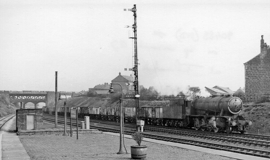
| DescriptionThornhill (Dewsbury) railway station geograph-2146249.jpg |
English: Eastward from Thornhill Station, with westbound coal train. View eastward, towards Wakefield, Normanton etc.; ex-Lancashire & Yorkshire Calder Valley main line (Normanton - Wakefield - Sowerby Bridge - Manchester). In the background are the bridge of the ex-Midland branch from Royston to Dewsbury (Savile Town), closed 18/12/50. Thornhill (L&Y) Station was closed 1/1/62 (goods 30/9/63), but the main line remains open |
| Date | |
| Source | From geograph.org.uk |
| Author | Ben Brooksbank |
| Permission (Reusing this file) |
Creative Commons Attribution Share-alike license 2.0 |
| Camera location | 53° 40′ 34.55″ N, 1° 37′ 58.86″ W | View this and other nearby images on: OpenStreetMap |
|---|
Licensing

|
This image was taken from the Geograph project collection. See this photograph's page on the Geograph website for the photographer's contact details. The copyright on this image is owned by Ben Brooksbank and is licensed for reuse under the Creative Commons Attribution-ShareAlike 2.0 license.
|
This file is licensed under the Creative Commons Attribution-Share Alike 2.0 Generic license.
Attribution: Ben Brooksbank
- You are free:
- to share – to copy, distribute and transmit the work
- to remix – to adapt the work
- Under the following conditions:
- attribution – You must give appropriate credit, provide a link to the license, and indicate if changes were made. You may do so in any reasonable manner, but not in any way that suggests the licensor endorses you or your use.
- share alike – If you remix, transform, or build upon the material, you must distribute your contributions under the same or compatible license as the original.
Captions
Add a one-line explanation of what this file represents
Items portrayed in this file
depicts
some value
53°40'34.554"N, 1°37'58.861"W
18 March 1961
image/jpeg
File history
Click on a date/time to view the file as it appeared at that time.
| Date/Time | Thumbnail | Dimensions | User | Comment | |
|---|---|---|---|---|---|
| current | 14:59, 6 November 2010 | | 1,024 × 610 (110 KB) | Chevin | == {{int:filedesc}} == {{Information |Description={{en|1=Eastward from Thornhill Station, with westbound coal train View eastward, towards Wakefield, Normanton etc.; ex-Lancashire & Yorkshire Calder Valley main line (Normanton - Wakefield - Sowerby Bridge |
File usage
The following pages on the English Wikipedia use this file (pages on other projects are not listed):
Global file usage
The following other wikis use this file:
- Usage on www.wikidata.org
Metadata
This file contains additional information, probably added from the digital camera or scanner used to create or digitize it.
If the file has been modified from its original state, some details may not fully reflect the modified file.
| Image title | EPSON scanner image |
|---|---|
| Orientation | Normal |
| Horizontal resolution | 157 dpc |
| Vertical resolution | 157 dpc |
| Software used | Adobe Photoshop Elements 3.0 Windows |
| File change date and time | 22:59, 4 November 2010 |
| Color space | Uncalibrated |
_railway_station_geograph-2146249.jpg)