File:The_former_Melrose_Railway_Station_-_geograph.org.uk_-_255694.jpg
From Wikipedia, the free encyclopedia
No higher resolution available.
The_former_Melrose_Railway_Station_-_geograph.org.uk_-_255694.jpg (640 × 480 pixels, file size: 48 KB, MIME type: image/jpeg)
| This is a file from the Wikimedia Commons. Information from its description page there is shown below. Commons is a freely licensed media file repository. You can help. |
Summary
| DescriptionThe former Melrose Railway Station - geograph.org.uk - 255694.jpg |
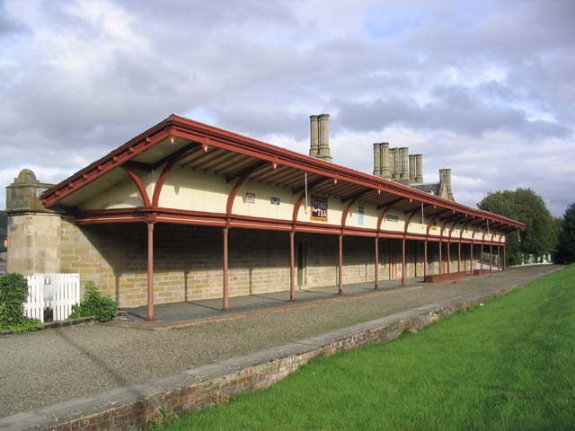
English: The former Melrose Railway Station This is one of the few remaining railway buildings on the Edinburgh to Carlisle Waverley Railway Line, a route that was closed in 1969. This elegant canopy with cast iron lotus-capitalled columns, covered the up platform. The remaining station buildings have been refurbished and now contain a restaurant and a small museum. The down platform and associated buildings were demolished to make way for the A6091 Melrose bypass road.
(Source: Borders and Berwick, An Architectural Guide by Charles Alexander Strang and Borders Railways Rambles by Alasdair Wham) |
| Date | |
| Source | From geograph.org.uk |
| Author | Walter Baxter |
| Attribution (required by the license) InfoField | Walter Baxter / The former Melrose Railway Station / |
InfoField | Walter Baxter / The former Melrose Railway Station |
| Object location | 55° 35′ 50″ N, 2° 43′ 12″ W | View this and other nearby images on: OpenStreetMap |
|---|
Licensing

|
This image was taken from the Geograph project collection. See this photograph's page on the Geograph website for the photographer's contact details. The copyright on this image is owned by Walter Baxter and is licensed for reuse under the Creative Commons Attribution-ShareAlike 2.0 license.
|
This file is licensed under the Creative Commons Attribution-Share Alike 2.0 Generic license.
Attribution: Walter Baxter
- You are free:
- to share – to copy, distribute and transmit the work
- to remix – to adapt the work
- Under the following conditions:
- attribution – You must give appropriate credit, provide a link to the license, and indicate if changes were made. You may do so in any reasonable manner, but not in any way that suggests the licensor endorses you or your use.
- share alike – If you remix, transform, or build upon the material, you must distribute your contributions under the same or compatible license as the original.
Captions
Add a one-line explanation of what this file represents
Items portrayed in this file
depicts
some value
8 October 2006
55°35'49.6"N, 2°43'12.0"W
File history
Click on a date/time to view the file as it appeared at that time.
| Date/Time | Thumbnail | Dimensions | User | Comment | |
|---|---|---|---|---|---|
| current | 17:51, 25 August 2010 | | 640 × 480 (48 KB) | GeographBot | == {{int:filedesc}} == {{Information |description={{en|1=The former Melrose Railway Station This is one of the few remaining railway buildings on the Edinburgh to Carlisle Waverley Railway Line, a route that was closed in 1969. This elegant canopy with ca |
File usage
The following pages on the English Wikipedia use this file (pages on other projects are not listed):
Global file usage
The following other wikis use this file:
- Usage on de.wikipedia.org
- Usage on fi.wikipedia.org
- Usage on www.wikidata.org
Metadata
This file contains additional information, probably added from the digital camera or scanner used to create or digitize it.
If the file has been modified from its original state, some details may not fully reflect the modified file.
| _error | 0 |
|---|