File:Strasbourg_-_Straßenbahn_-_Netzplan.png
From Wikipedia, the free encyclopedia
Size of this preview: 497 × 600 pixels. Other resolutions: 199 × 240 pixels | 398 × 480 pixels | 636 × 768 pixels | 848 × 1,024 pixels | 1,697 × 2,048 pixels | 3,425 × 4,134 pixels.
Original file (3,425 × 4,134 pixels, file size: 1.87 MB, MIME type: image/png)
| This is a file from the Wikimedia Commons. Information from its description page there is shown below. Commons is a freely licensed media file repository. You can help. |

|
This transport map image could be re-created using vector graphics as an SVG file. This has several advantages; see Commons:Media for cleanup for more information. If an SVG form of this image is available, please upload it and afterwards replace this template with
{{vector version available|new image name}}.
It is recommended to name the SVG file “Strasbourg - Straßenbahn - Netzplan.svg”—then the template Vector version available (or Vva) does not need the new image name parameter. |
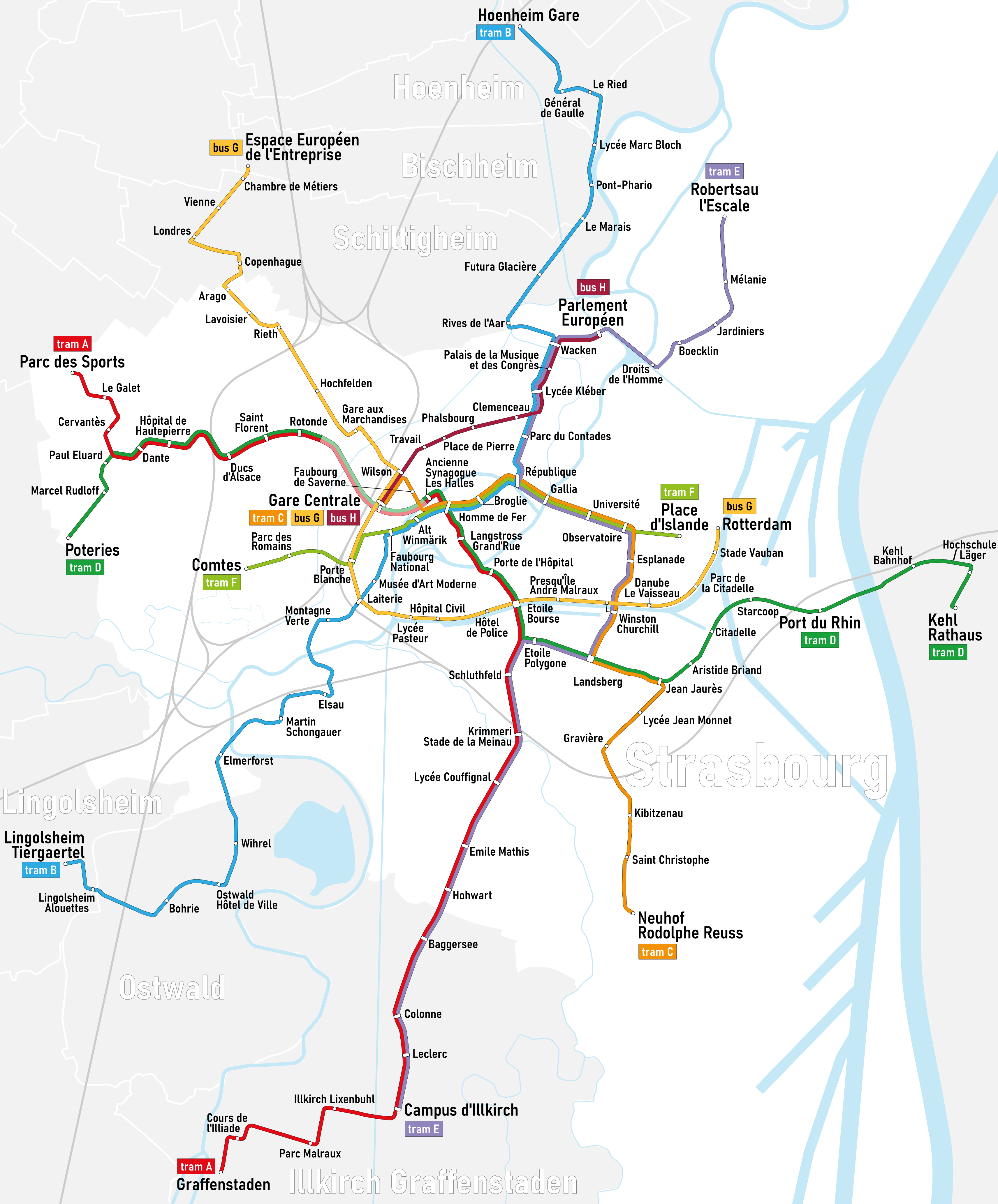
| DescriptionStrasbourg - Straßenbahn - Netzplan.png |
|
| Date | |
| Source | Self made, based on a transport map from the CTS |
| Author | Maximilian Dörrbecker (Chumwa) |
| Permission (Reusing this file) |
I, the copyright holder of this work, hereby publish it under the following license: This file is licensed under the Creative Commons Attribution-Share Alike 2.5 Generic license.
Sie dürfen das Bild zu den folgenden Bedingungen nutzen:
|
| Other versions |
|

.png)
.png)
Captions
Add a one-line explanation of what this file represents
Items portrayed in this file
depicts
January 2008
image/png
File history
Click on a date/time to view the file as it appeared at that time.
| Date/Time | Thumbnail | Dimensions | User | Comment | |
|---|---|---|---|---|---|
| current | 18:52, 23 November 2023 | | 3,425 × 4,134 (1.87 MB) | B1000s | Reproduction de la carte de Chumwa inactif depuis janvier 2021. Ajout de la ligne G entre Gare Centrale et Rotterdam |
| 07:04, 19 September 2020 |  | 1,834 × 1,957 (642 KB) | Chumwa | extension of Line F | |
| 07:35, 13 June 2020 |  | 1,834 × 1,957 (636 KB) | Chumwa | added BHNS line H | |
| 19:34, 17 June 2019 |  | 1,834 × 1,957 (632 KB) | Chumwa | extension of line E | |
| 18:48, 4 December 2018 |  | 1,834 × 1,957 (622 KB) | Chumwa | I've confused the files | |
| 07:55, 4 December 2018 |  | 2,003 × 2,174 (874 KB) | Chumwa | Kehl extension | |
| 07:50, 4 December 2018 |  | 1,834 × 1,957 (622 KB) | Chumwa | Kehl extension | |
| 07:48, 27 May 2017 |  | 1,657 × 1,957 (599 KB) | Chumwa | Citadelle and Starcoop stations aren't opened yet | |
| 07:25, 1 May 2017 |  | 1,657 × 1,957 (598 KB) | Chumwa | Kehl extension | |
| 21:44, 31 May 2016 |  | 1,598 × 1,957 (580 KB) | Chumwa | line colours changed |
File usage
The following pages on the English Wikipedia use this file (pages on other projects are not listed):
Global file usage
The following other wikis use this file:
- Usage on de.wikipedia.org
- Usage on eo.wikipedia.org
- Usage on es.wikipedia.org
- Usage on eu.wikipedia.org
- Usage on fa.wikipedia.org
- Usage on fr.wikipedia.org
- Tramway de Strasbourg
- Ligne B du tramway de Strasbourg
- Ligne C du tramway de Strasbourg
- Ligne E du tramway de Strasbourg
- Ligne A du tramway de Strasbourg
- Ligne D du tramway de Strasbourg
- Ligne F du tramway de Strasbourg
- Ligne G du BHNS de Strasbourg
- Bus à haut niveau de service de Strasbourg
- Ligne H du BHNS de Strasbourg
- Usage on he.wikivoyage.org
- Usage on hu.wikipedia.org
- Usage on it.wikipedia.org
- Usage on ja.wikipedia.org
- Usage on meta.wikimedia.org
- Usage on nl.wikipedia.org
- Usage on pl.wikipedia.org
- Usage on ru.wikipedia.org
- Usage on sv.wikipedia.org
- Usage on uk.wikipedia.org
- Usage on www.wikidata.org
- Usage on zh.wikipedia.org
Metadata
This file contains additional information, probably added from the digital camera or scanner used to create or digitize it.
If the file has been modified from its original state, some details may not fully reflect the modified file.
| Horizontal resolution | 118.11 dpc |
|---|---|
| Vertical resolution | 118.11 dpc |
| Software used |