File:StraitsMackinac_ISS010-E-20813.jpg
From Wikipedia, the free encyclopedia
No higher resolution available.
StraitsMackinac_ISS010-E-20813.jpg (320 × 240 pixels, file size: 18 KB, MIME type: image/jpeg)
| This is a file from the Wikimedia Commons. Information from its description page there is shown below. Commons is a freely licensed media file repository. You can help. |
|
This is an image of a place or building that is listed on the National Register of Historic Places in the United States of America. Its reference number is 88000442. |
Summary
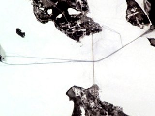
| DescriptionStraitsMackinac ISS010-E-20813.jpg | w:Straits of Mackinac (Michigan, USA) frozen over. The w:Mackinac Bridge stretches over the ice, while paths made by icebreakers cut through the ice. |
| Date | |
| Source | http://earthobservatory.nasa.gov/Newsroom/NewImages/images.php3?img_id=16890 |
| Author | ISS Crew Earth Observations experiment and the Image Science & Analysis Group at the Johnson Space Center. Cropped and adjusted by Howcheng. |
| Permission (Reusing this file) |
NASA, public domain |
| Other versions | Original sample available at source URL. |
| Object location | 45° 51′ 18″ N, 84° 51′ 48″ W | View this and other nearby images on: OpenStreetMap |
|---|
Licensing
| Public domainPublic domainfalsefalse |
This file is in the public domain in the United States because it was created by the Image Science & Analysis Laboratory, of the NASA Johnson Space Center. NASA copyright policy states that "NASA material is not protected by copyright unless noted". (NASA media use guidelines or Conditions of Use of Astronaut Photographs).
Photo source: ISS010-E-20813.
العربيَّة | Deutsch | English | español | français | italiano | kurdî | македонски | മലയാളം | português | sicilianu | +/− |
Captions
Add a one-line explanation of what this file represents
Items portrayed in this file
depicts
22 March 2005
45°51'18"N, 84°51'47"W
File history
Click on a date/time to view the file as it appeared at that time.
| Date/Time | Thumbnail | Dimensions | User | Comment | |
|---|---|---|---|---|---|
| current | 21:55, 12 May 2006 | | 320 × 240 (18 KB) | Holly Cheng | ==Summary== {{Information | Description=w:Straits of Mackinac (Michigan, USA) frozen over. The w:Mackinac Bridge stretches over the ice, while paths made by icebreakers cut through the ice. | Source=http://earthobservatory.nasa.gov/Newsroom/NewIma |
File usage
The following pages on the English Wikipedia use this file (pages on other projects are not listed):
Global file usage
The following other wikis use this file:
- Usage on ceb.wikipedia.org
- Usage on es.wikipedia.org
- Usage on fr.wikipedia.org
- Usage on vi.wikipedia.org
- Usage on www.wikidata.org
Metadata
This file contains additional information, probably added from the digital camera or scanner used to create or digitize it.
If the file has been modified from its original state, some details may not fully reflect the modified file.
| Orientation | Normal |
|---|---|
| Horizontal resolution | 72 dpi |
| Vertical resolution | 72 dpi |
| Software used | Adobe Photoshop CS Macintosh |
| File change date and time | 15:33, 22 April 2005 |
| Color space | Uncalibrated |