File:St_Benedict's_Church_-_geograph.org.uk_-_19933.jpg
From Wikipedia, the free encyclopedia
No higher resolution available.
St_Benedict's_Church_-_geograph.org.uk_-_19933.jpg (640 × 480 pixels, file size: 76 KB, MIME type: image/jpeg)
| This is a file from the Wikimedia Commons. Information from its description page there is shown below. Commons is a freely licensed media file repository. You can help. |
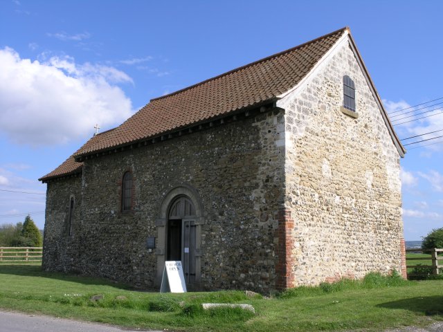
This is a photo of listed building number 1363120. |
Summary
| DescriptionSt Benedict's Church - geograph.org.uk - 19933.jpg |
English: St Benedict's Church, Snodland, Kent. It served a small village that surrounded it, but this was wiped out in the Black Death in 1349. The church has been used as a barn for most of the time since then, but was restored in 1935. |
| Date | |
| Source | From geograph.org.uk |
| Author | Hywel Williams |
| Attribution (required by the license) InfoField | Hywel Williams / St Benedict's Church / |
InfoField | Hywel Williams / St Benedict's Church |
| Camera location | 51° 19′ 59″ N, 0° 24′ 54″ E | View this and other nearby images on: OpenStreetMap |
|---|
| Object location | 51° 19′ 57″ N, 0° 25′ 00″ E | View this and other nearby images on: OpenStreetMap |
|---|
Licensing

|
This image was taken from the Geograph project collection. See this photograph's page on the Geograph website for the photographer's contact details. The copyright on this image is owned by Hywel Williams and is licensed for reuse under the Creative Commons Attribution-ShareAlike 2.0 license.
|
This file is licensed under the Creative Commons Attribution-Share Alike 2.0 Generic license.
Attribution: Hywel Williams
- You are free:
- to share – to copy, distribute and transmit the work
- to remix – to adapt the work
- Under the following conditions:
- attribution – You must give appropriate credit, provide a link to the license, and indicate if changes were made. You may do so in any reasonable manner, but not in any way that suggests the licensor endorses you or your use.
- share alike – If you remix, transform, or build upon the material, you must distribute your contributions under the same or compatible license as the original.
Captions
Add a one-line explanation of what this file represents
Items portrayed in this file
depicts
some value
2 May 2005
51°19'58.91"N, 0°24'54.00"E
51°19'57.50"N, 0°25'0.12"E
File history
Click on a date/time to view the file as it appeared at that time.
| Date/Time | Thumbnail | Dimensions | User | Comment | |
|---|---|---|---|---|---|
| current | 05:07, 30 January 2010 | | 640 × 480 (76 KB) | GeographBot | == {{int:filedesc}} == {{Information |description={{en|1=St Benedict's Church. Near Pilgrim's Way, this church was built in the 11th century though some parts may even be older. It originally served a small village that surrounded it, but this was wiped |
File usage
The following pages on the English Wikipedia use this file (pages on other projects are not listed):
Global file usage
The following other wikis use this file:
- Usage on azb.wikipedia.org
- Usage on de.wikipedia.org
- Usage on fa.wikipedia.org
- Usage on ru.wikipedia.org
- Usage on www.wikidata.org
Metadata
This file contains additional information, probably added from the digital camera or scanner used to create or digitize it.
If the file has been modified from its original state, some details may not fully reflect the modified file.
| _error | 0 |
|---|