File:Somerleyton_swing_bridge_-_geograph.org.uk_-_1506014.jpg
From Wikipedia, the free encyclopedia
No higher resolution available.
Somerleyton_swing_bridge_-_geograph.org.uk_-_1506014.jpg (640 × 395 pixels, file size: 91 KB, MIME type: image/jpeg)
| This is a file from the Wikimedia Commons. Information from its description page there is shown below. Commons is a freely licensed media file repository. You can help. |
Summary
| DescriptionSomerleyton swing bridge - geograph.org.uk - 1506014.jpg |
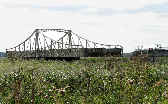
English: Somerleyton swing bridge. The bridge is closed to rail traffic in order to let a boat pass that is travelling on the River Waveney. The view to the river is obscured by the high reeds growing alongside both sides of it. For a view of the bridge as it swings around and re-connects with the rail track see > 1506020.
Somerleyton swing bridge > https://www.geograph.org.uk/photo/1506009 - it is located a short distance to the north-west of Somerleyton railway station > https://www.geograph.org.uk/photo/1505978 and takes the railway line over the River Waveney - is 14.40 metres wide and has a clearance f 2.60 metres. The bridge is kept in alignment with the rails on the land by means of a bolt. The signals on the far side of the bridge are connected mechanically and carried across the length of the bridge on rods. The signal box > https://www.geograph.org.uk/photo/1506027 is a brick-built example of the Great Eastern's standard design which was introduced in 1886, and it is quite large because the bridge operating gear used to occupy part of the box. Outside there is a board that can be used to indicate to shipping how long they will have to wait, other boards can be slid across to indicate the waiting time. For a view of the signal box and bridge taken from Somerleyton station see > https://www.geograph.org.uk/photo/1505959. |
| Date | |
| Source | From geograph.org.uk |
| Author | Evelyn Simak |
| Attribution (required by the license) InfoField | Evelyn Simak / Somerleyton swing bridge / |
InfoField | Evelyn Simak / Somerleyton swing bridge |
| Camera location | 52° 30′ 48″ N, 1° 38′ 54″ E | View this and other nearby images on: OpenStreetMap |
|---|
| Object location | 52° 30′ 44″ N, 1° 38′ 50″ E | View this and other nearby images on: OpenStreetMap |
|---|
Licensing

|
This image was taken from the Geograph project collection. See this photograph's page on the Geograph website for the photographer's contact details. The copyright on this image is owned by Evelyn Simak and is licensed for reuse under the Creative Commons Attribution-ShareAlike 2.0 license.
|
This file is licensed under the Creative Commons Attribution-Share Alike 2.0 Generic license.
Attribution: Evelyn Simak
- You are free:
- to share – to copy, distribute and transmit the work
- to remix – to adapt the work
- Under the following conditions:
- attribution – You must give appropriate credit, provide a link to the license, and indicate if changes were made. You may do so in any reasonable manner, but not in any way that suggests the licensor endorses you or your use.
- share alike – If you remix, transform, or build upon the material, you must distribute your contributions under the same or compatible license as the original.
Captions
Add a one-line explanation of what this file represents
Items portrayed in this file
depicts
some value
24 September 2009
52°30'48.42"N, 1°38'53.88"E
52°30'44.35"N, 1°38'49.92"E
0.002 second
14.2 millimetre
File history
Click on a date/time to view the file as it appeared at that time.
| Date/Time | Thumbnail | Dimensions | User | Comment | |
|---|---|---|---|---|---|
| current | 21:42, 2 March 2011 | | 640 × 395 (91 KB) | GeographBot | == {{int:filedesc}} == {{Information |description={{en|1=Somerleyton swing bridge The bridge is closed to rail traffic in order to let a boat pass that is travelling on the River Waveney. The view to the river is obscured by the high reeds growing alongsi |
File usage
The following pages on the English Wikipedia use this file (pages on other projects are not listed):
Global file usage
The following other wikis use this file:
- Usage on de.wikipedia.org
Metadata
This file contains additional information, probably added from the digital camera or scanner used to create or digitize it.
If the file has been modified from its original state, some details may not fully reflect the modified file.
| Camera manufacturer | Canon |
|---|---|
| Camera model | Canon PowerShot S3 IS |
| Exposure time | 1/500 sec (0.002) |
| F-number | f/4 |
| Date and time of data generation | 12:37, 24 September 2009 |
| Lens focal length | 14.2 mm |
| Orientation | Normal |
| Horizontal resolution | 180 dpi |
| Vertical resolution | 180 dpi |
| File change date and time | 15:01, 25 September 2009 |
| Y and C positioning | Centered |
| Software used | Adobe Photoshop CS Windows |
| Exif version | 2.2 |
| Date and time of digitizing | 12:37, 24 September 2009 |
| Image compression mode | 3 |
| Shutter speed | 8.96875 |
| APEX aperture | 4 |
| Exposure bias | 0 |
| Maximum land aperture | 3.625 APEX (f/3.51) |
| Metering mode | Pattern |
| Flash | Flash did not fire, compulsory flash suppression |
| Color space | sRGB |
| Focal plane X resolution | 10,097.777777778 |
| Focal plane Y resolution | 10,082.840236686 |
| Focal plane resolution unit | inches |
| Sensing method | One-chip color area sensor |
| Custom image processing | Normal process |
| Exposure mode | Auto exposure |
| White balance | Auto white balance |
| Digital zoom ratio | 1 |
| Scene capture type | Standard |