File:Slavonia02.png
From Wikipedia, the free encyclopedia
Size of this preview: 709 × 600 pixels. Other resolutions: 284 × 240 pixels | 568 × 480 pixels | 797 × 674 pixels.
Original file (797 × 674 pixels, file size: 81 KB, MIME type: image/png)
| This is a file from the Wikimedia Commons. Information from its description page there is shown below. Commons is a freely licensed media file repository. You can help. |
Summary
| DescriptionSlavonia02.png |
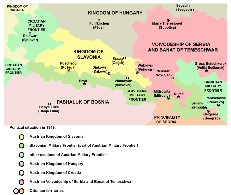
English: Kingdom of Slavonia in 1849.
Српски / srpski: Kraljevina Slavonija 1849. godine. |
| Date | 28 December 2006 (original upload date) |
| Source | Own work |
| Author | PANONIAN |
Licensing
| Public domainPublic domainfalsefalse |
| I, the copyright holder of this work, release this work into the public domain. This applies worldwide. In some countries this may not be legally possible; if so: I grant anyone the right to use this work for any purpose, without any conditions, unless such conditions are required by law. |
References
- http://www.terra.es/personal7/jqvaraderey/185915BK.GIF
- http://www.historyonmaps.com/BWSamples/Magyarorszagadminsitrative.html
- http://terkepek.adatbank.transindex.ro/kepek/netre/57.gif
- http://www.zum.de/whkmla/histatlas/balkans/croslav1840.gif
- http://www.crohis.com/shisatlas3/vojkrajina.htm
- The Times History of Europe, Times Books, 2002.
- Istorijski atlas, Zavod za udžbenike i nastavna sredstva - Zavod za kartografiju "Geokarta", Beograd, 1999.
- Peter Rokai - Zoltan Đere - Tibor Pal - Aleksandar Kasaš, Istorija Mađara, Beograd, 2002.
Captions
Add a one-line explanation of what this file represents
Items portrayed in this file
depicts
28 December 2006
image/png
File history
Click on a date/time to view the file as it appeared at that time.
| Date/Time | Thumbnail | Dimensions | User | Comment | |
|---|---|---|---|---|---|
| current | 09:22, 12 April 2011 | | 797 × 674 (81 KB) | PANONIAN | improved version |
| 19:26, 20 May 2007 |  | 726 × 510 (21 KB) | Minestrone | Enhanced version | |
| 15:41, 28 December 2006 |  | 726 × 510 (13 KB) | Electionworld | {{ew|en|PANONIAN}} historic map (self made) {{PD-self}} Category:Maps of the history of Croatia Category:Maps of the history of Vojvodina |
File usage
The following pages on the English Wikipedia use this file (pages on other projects are not listed):
Global file usage
The following other wikis use this file:
- Usage on an.wikipedia.org
- Usage on be.wikipedia.org
- Usage on cs.wikipedia.org
- Usage on de.wikipedia.org
- Usage on et.wikipedia.org
- Usage on eu.wikipedia.org
- Usage on fa.wikipedia.org
- Usage on fr.wikipedia.org
- Usage on gl.wikipedia.org
- Usage on he.wikipedia.org
- Usage on it.wikipedia.org
- Usage on ja.wikipedia.org
- Usage on mk.wikipedia.org
- Usage on nl.wikipedia.org
- Usage on pt.wikipedia.org
- Usage on ro.wikipedia.org
- Usage on sr.wikipedia.org
- Usage on uk.wikipedia.org
Retrieved from "https://en.wikipedia.org/wiki/File:Slavonia02.png"