File:Scotora2_PJC.jpg
From Wikipedia, the free encyclopedia
Original file (3,888 × 2,592 pixels, file size: 5.56 MB, MIME type: image/jpeg)
| This is a file from the Wikimedia Commons. Information from its description page there is shown below. Commons is a freely licensed media file repository. You can help. |
Summary
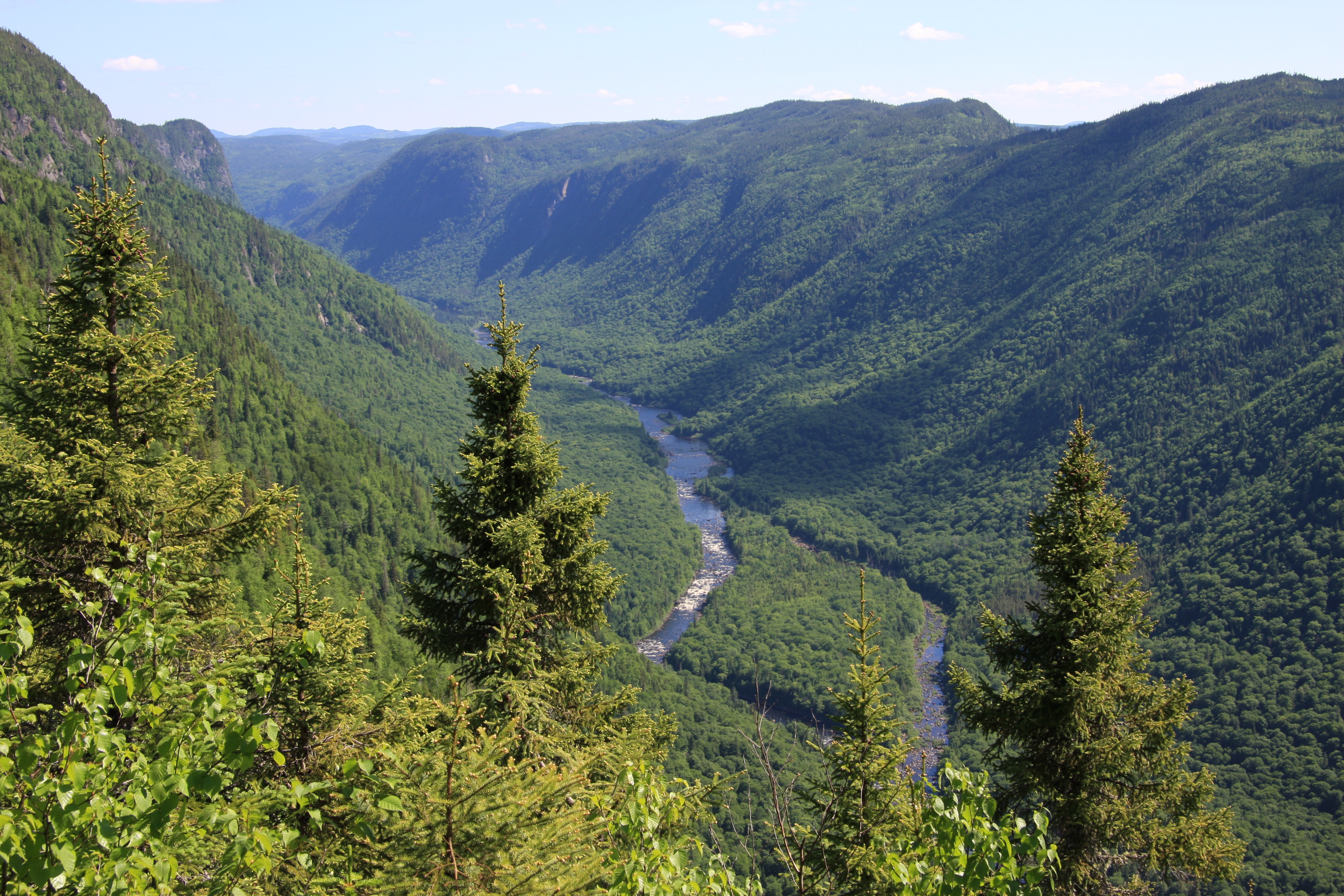
| DescriptionScotora2 PJC.jpg |
English: Scenic view of Jacques-Cartier River valley from Andante montain, Jacques-Cartier National Park, Quebec, Canada
Français : Vue panoramique de la vallée de la Rivière Jacques-Cartier du sommet du Mont Andante, Parc national de la Jacques-Cartier, Québec, Canada |
| Date | |
| Source | Own work |
| Author | Cephas |
| Camera location | 47° 20′ 19″ N, 71° 27′ 31.3″ W | View this and other nearby images on: OpenStreetMap |
|---|
Licensing

|
Permission is granted to copy, distribute and/or modify this document under the terms of the GNU Free Documentation License, Version 1.2 or any later version published by the Free Software Foundation; with no Invariant Sections, no Front-Cover Texts, and no Back-Cover Texts. A copy of the license is included in the section entitled GNU Free Documentation License.http://www.gnu.org/copyleft/fdl.htmlGFDLGNU Free Documentation Licensetruetrue |
- You are free:
- to share – to copy, distribute and transmit the work
- to remix – to adapt the work
- Under the following conditions:
- attribution – You must give appropriate credit, provide a link to the license, and indicate if changes were made. You may do so in any reasonable manner, but not in any way that suggests the licensor endorses you or your use.
- share alike – If you remix, transform, or build upon the material, you must distribute your contributions under the same or compatible license as the original.
This image has been assessed using the Quality image guidelines and is considered a Quality image.
العربية ∙ جازايرية ∙ беларуская ∙ беларуская (тарашкевіца) ∙ български ∙ বাংলা ∙ català ∙ čeština ∙ Cymraeg ∙ Deutsch ∙ Schweizer Hochdeutsch ∙ Zazaki ∙ Ελληνικά ∙ English ∙ Esperanto ∙ español ∙ eesti ∙ euskara ∙ فارسی ∙ suomi ∙ français ∙ galego ∙ עברית ∙ हिन्दी ∙ hrvatski ∙ magyar ∙ հայերեն ∙ Bahasa Indonesia ∙ italiano ∙ 日本語 ∙ Jawa ∙ ქართული ∙ 한국어 ∙ kurdî ∙ Lëtzebuergesch ∙ lietuvių ∙ македонски ∙ മലയാളം ∙ मराठी ∙ Bahasa Melayu ∙ Nederlands ∙ Norfuk / Pitkern ∙ polski ∙ português ∙ português do Brasil ∙ rumantsch ∙ română ∙ русский ∙ sicilianu ∙ slovenčina ∙ slovenščina ∙ shqip ∙ српски / srpski ∙ svenska ∙ தமிழ் ∙ తెలుగు ∙ ไทย ∙ Tagalog ∙ Türkçe ∙ toki pona ∙ українська ∙ vèneto ∙ Tiếng Việt ∙ 中文 ∙ 中文(简体) ∙ 中文(繁體) ∙ +/− |
Captions
Items portrayed in this file
depicts
24 June 2009
47°20'19.000"N, 71°27'31.298"W
0.01 second
10
35 millimetre
100
image/jpeg
File history
Click on a date/time to view the file as it appeared at that time.
| Date/Time | Thumbnail | Dimensions | User | Comment | |
|---|---|---|---|---|---|
| current | 22:50, 24 June 2009 | | 3,888 × 2,592 (5.56 MB) | Cephas | {{Information |Description={{en|1=Scenic view of Jacques-Cartier River valley from Andante montain, Jacques-Cartier National Park, Quebec, Canada}} {{fr|1=Vue panoramique de la vallée de |
File usage
Global file usage
The following other wikis use this file:
- Usage on ca.wikimedia.org
- Usage on de.wikipedia.org
- Usage on en.wikivoyage.org
- Usage on es.wikipedia.org
- Usage on fr.wikipedia.org
- Parcs nationaux du Québec
- Portail:Ville de Québec/Lumière sur/Archives
- Projet:Impression/Quality images/112
- Portail:Ville de Québec/Lumière
- Portail:Ville de Québec/Lumière/31
- Sentier des Jésuites
- Liste des parcs nationaux des Laurentides
- Utilisateur:YanikB/Tableau wikidata
- Utilisateur:Exp JC/Brouillon
- Usage on fr.wikivoyage.org
- Parc national de la Jacques-Cartier
- Réserve faunique des Laurentides
- Château-Richer
- Lac-Beauport
- Sainte-Brigitte-de-Laval
- Stoneham-et-Tewkesbury
- Saint-Gabriel-de-Valcartier
- Shannon (Québec)
- Fossambault-sur-le-Lac
- Lac-Saint-Joseph
- Sainte-Catherine-de-la-Jacques-Cartier
- Lac-Delage
- Lac-Croche
- Lac-Jacques-Cartier
- Usage on fy.wikipedia.org
- Usage on he.wikipedia.org
- Usage on lad.wikipedia.org
- Usage on mk.wikipedia.org
- Usage on nl.wikipedia.org
- Usage on pt.wikipedia.org
- Usage on ru.wikipedia.org
- Usage on sk.wikipedia.org
- Usage on sr.wikipedia.org
- Usage on uk.wikipedia.org
- Usage on vls.wikipedia.org
- Usage on www.wikidata.org
Metadata
This file contains additional information, probably added from the digital camera or scanner used to create or digitize it.
If the file has been modified from its original state, some details may not fully reflect the modified file.
| Camera manufacturer | Canon |
|---|---|
| Camera model | Canon EOS 40D |
| Exposure time | 1/100 sec (0.01) |
| F-number | f/10 |
| ISO speed rating | 100 |
| Date and time of data generation | 09:58, 24 June 2009 |
| Lens focal length | 35 mm |
| Orientation | Normal |
| Horizontal resolution | 72 dpi |
| Vertical resolution | 72 dpi |
| File change date and time | 09:58, 24 June 2009 |
| Y and C positioning | Co-sited |
| Exposure Program | Landscape mode (for landscape photos with the background in focus) |
| Exif version | 2.21 |
| Date and time of digitizing | 09:58, 24 June 2009 |
| Meaning of each component |
|
| Shutter speed | 6.625 |
| APEX aperture | 6.625 |
| Exposure bias | 0 |
| Metering mode | Pattern |
| Flash | Flash did not fire, compulsory flash suppression |
| DateTime subseconds | 01 |
| DateTimeOriginal subseconds | 01 |
| DateTimeDigitized subseconds | 01 |
| Supported Flashpix version | 1 |
| Color space | sRGB |
| Focal plane X resolution | 4,438.3561643836 |
| Focal plane Y resolution | 4,445.9691252144 |
| Focal plane resolution unit | inches |
| Custom image processing | Normal process |
| Exposure mode | Auto exposure |
| White balance | Auto white balance |
| Scene capture type | Standard |
| GPS tag version | 0.0.2.2 |