File:Rus-10c-ethn.png
From Wikipedia, the free encyclopedia
Size of this preview: 492 × 600 pixels. Other resolutions: 197 × 240 pixels | 394 × 480 pixels | 630 × 768 pixels | 840 × 1,024 pixels | 2,241 × 2,731 pixels.
Original file (2,241 × 2,731 pixels, file size: 257 KB, MIME type: image/png)
| This is a file from the Wikimedia Commons. Information from its description page there is shown below. Commons is a freely licensed media file repository. You can help. |
Summary
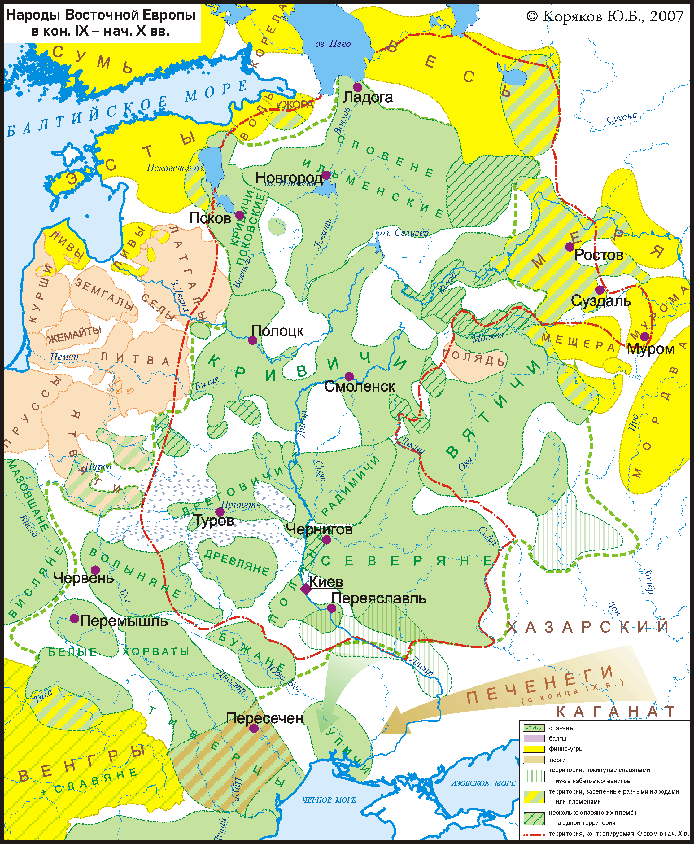
| DescriptionRus-10c-ethn.png |
Русский: Карта расселения славян и их соседей в кон. 9 -- нач. 10 вв. в Восточной Европе. Показана граница Киевской Руси на нач. 10 в. Основана на археологических картах и описаниях, в частности взятых из работ В.В.Седова (в основном данные по славянам) и тома "Финно-угры и балты в эпоху средневековья" (М.: 1987) из серии Археология СССР (в основном данные по балтам и финно-уграм). English: Ethnic groups of East Europe in late 9 -- early 10 cc.
Deutsch: Ethnische Gruppen in Osteuropa im späten 9. bis frühen 10. Jahrhundert |
| Date | |
| Source | Own work |
| Author | Koryakov Yuri |

|
This map image could be re-created using vector graphics as an SVG file. This has several advantages; see Commons:Media for cleanup for more information. If an SVG form of this image is available, please upload it and afterwards replace this template with
{{vector version available|new image name}}.
It is recommended to name the SVG file “Rus-10c-ethn.svg”—then the template Vector version available (or Vva) does not need the new image name parameter. |
The factual accuracy of this map or the file name is disputed.
Reason: The Byzantine presence in the Crimea and the Volokhs are erased, although they are mentioned in the Chronicle of the ancient times of the monk Nestor. This map supports an Austro-Hungarian theory of the 19th century, diffused by Eduard Rössler, according to which the Eastern Romance languages almost disappeared for a thousand years before reappearing suddenly and massively in the 13th century. There is no reason to take here this side rather than another, and even less to consider only this one as academic to the exclusion of others. |  |
Licensing
I, the copyright holder of this work, hereby publish it under the following license:
This file is licensed under the Creative Commons Attribution-Share Alike 3.0 Unported license.
- You are free:
- to share – to copy, distribute and transmit the work
- to remix – to adapt the work
- Under the following conditions:
- attribution – You must give appropriate credit, provide a link to the license, and indicate if changes were made. You may do so in any reasonable manner, but not in any way that suggests the licensor endorses you or your use.
- share alike – If you remix, transform, or build upon the material, you must distribute your contributions under the same or compatible license as the original.
Captions
Add a one-line explanation of what this file represents
Items portrayed in this file
depicts
some value
27 January 2007
image/png
File history
Click on a date/time to view the file as it appeared at that time.
| Date/Time | Thumbnail | Dimensions | User | Comment | |
|---|---|---|---|---|---|
| current | 19:39, 25 November 2022 | | 2,241 × 2,731 (257 KB) | Gyalu22 | Reverted to version as of 14:40, 31 March 2019 (UTC) |
| 07:34, 25 March 2020 |  | 2,241 × 2,731 (267 KB) | Gleb Zajarski | На предыдущей карте исправлены многие ошибки и карта там дополнена. | |
| 14:40, 31 March 2019 |  | 2,241 × 2,731 (257 KB) | Koryakov Yuri | Reverted to version as of 11:29, 15 July 2015 (UTC) | |
| 07:17, 29 June 2017 |  | 2,241 × 2,731 (267 KB) | MAXHO | Подробности в Юго-Запад: Византия, Влахи/Волохи, Чангоши. Details on the South-Western part : Byzantine positions, Vlachs/Wallachians, Csangos. Source Древняя культура Молдавии, А... | |
| 11:29, 15 July 2015 |  | 2,241 × 2,731 (257 KB) | RokerHRO | optipng -o7 -i0 → 12.96% decrease | |
| 11:21, 4 October 2013 |  | 2,241 × 2,731 (296 KB) | Koryakov Yuri | User created page with UploadWizard |
File usage
The following pages on the English Wikipedia use this file (pages on other projects are not listed):
Global file usage
The following other wikis use this file:
- Usage on ba.wikipedia.org
- Usage on be.wikipedia.org
- Usage on bg.wikipedia.org
- Usage on ca.wikipedia.org
- Usage on ca.wiktionary.org
- Usage on ce.wikipedia.org
- Usage on de.wikipedia.org
- Usage on gl.wikipedia.org
- Usage on ja.wikipedia.org
- Usage on lt.wikipedia.org
- Usage on lv.wikipedia.org
- Usage on mn.wikipedia.org
- Usage on olo.wikipedia.org
- Usage on pl.wikipedia.org
- Usage on ru.wikipedia.org
- Русские
- Древнерусский язык
- Ятвяги
- Весь (племя)
- Кривичи
- Дреговичи
- Древляне
- Вепсский язык
- Мурома
- Мордва
- Балты
- Обсуждение:Малевич, Казимир Северинович
- Голядь
- Волыняне
- Водский язык
- Белые хорваты
- Древненовгородский диалект
- Ливский язык
- Ижорский язык
- Финно-угорские народы
- Днепровские балты
- Голядский язык
- Культура новгородских сопок
- Славянская колонизация Северо-Восточной Руси
- Население Древней Руси
- Культура смоленско-полоцких длинных курганов
- Обсуждение:Северная конфедерация племён
- Псковские кривичи
- Древнерусский извод церковнославянского языка
View more global usage of this file.
Metadata
This file contains additional information, probably added from the digital camera or scanner used to create or digitize it.
If the file has been modified from its original state, some details may not fully reflect the modified file.
| Horizontal resolution | 236.22 dpc |
|---|---|
| Vertical resolution | 236.22 dpc |
Retrieved from "https://en.wikipedia.org/wiki/File:Rus-10c-ethn.png"