File:Royston_and_Notton_railway_station.jpg
From Wikipedia, the free encyclopedia
No higher resolution available.
Royston_and_Notton_railway_station.jpg (640 × 413 pixels, file size: 126 KB, MIME type: image/jpeg)
| This is a file from the Wikimedia Commons. Information from its description page there is shown below. Commons is a freely licensed media file repository. You can help. |
Summary
| DescriptionRoyston and Notton railway station.jpg |
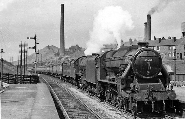
English: Royston and Notton Station, with train. View northward, towards Normanton and Leeds etc. The Up Thames-Clyde Express (09.20 Glasgow St Enoch to London St Pancras) makes a fine sight, double-headed by Stanier Class 5 (modified with double-chimney and Caprotti valve-gear) No. 44756 piloting 'Jubilee' Class 6 4-6-0 No. 45615 'Malay States'. Behind are the chimneys associated with New Monckton Colliery. In those days (1951), this was the four-track trunk route of the ex-Midland Railway main line between Sheffield and Leeds, through a region that teemed with heavy industry, coal mines, railway yards and junctions, with an immense amount of freight traffic. However, mining subsidence forced express trains to slow down through here. From 1/1/68 all passenger services ceased, Royston & Notton station closed and since 9/68 nothing has passed this way and the traffic that is left runs on other lines - if not by the M1! As we all know, since the 1980s the mines have been closed and industry along with rail freight traffic is a shadow of what it was. |
| Date | |
| Source | From geograph.org.uk |
| Author | Ben Brooksbank |
| Permission (Reusing this file) |
Creative Commons Attribution Share-alike license 2.0 |
| Camera location | 53° 36′ 03.24″ N, 1° 26′ 11.29″ W | View this and other nearby images on: OpenStreetMap |
|---|
Licensing

|
This image was taken from the Geograph project collection. See this photograph's page on the Geograph website for the photographer's contact details. The copyright on this image is owned by Ben Brooksbank and is licensed for reuse under the Creative Commons Attribution-ShareAlike 2.0 license.
|
This file is licensed under the Creative Commons Attribution-Share Alike 2.0 Generic license.
Attribution: Ben Brooksbank
- You are free:
- to share – to copy, distribute and transmit the work
- to remix – to adapt the work
- Under the following conditions:
- attribution – You must give appropriate credit, provide a link to the license, and indicate if changes were made. You may do so in any reasonable manner, but not in any way that suggests the licensor endorses you or your use.
- share alike – If you remix, transform, or build upon the material, you must distribute your contributions under the same or compatible license as the original.
Captions
Add a one-line explanation of what this file represents
Items portrayed in this file
depicts
some value
53°36'3.236"N, 1°26'11.288"W
24 July 1951
File history
Click on a date/time to view the file as it appeared at that time.
| Date/Time | Thumbnail | Dimensions | User | Comment | |
|---|---|---|---|---|---|
| current | 12:34, 11 September 2010 | | 640 × 413 (126 KB) | Chevin | == {{int:filedesc}} == {{Information |Description={{en|1=Royston and Notton Station, with train View northward, towards Normanton and Leeds etc. The Up Thames-Clyde Express (09.20 Glasgow St Enoch to London St Pancras) makes a fine sight, double-headed by |
File usage
The following pages on the English Wikipedia use this file (pages on other projects are not listed):
Global file usage
The following other wikis use this file:
- Usage on www.wikidata.org
Metadata
This file contains additional information, probably added from the digital camera or scanner used to create or digitize it.
If the file has been modified from its original state, some details may not fully reflect the modified file.
| Image title |
|
|---|---|
| Orientation | Normal |
| Horizontal resolution | 78 dpc |
| Vertical resolution | 78 dpc |
| Software used | Adobe Photoshop Elements 3.0 Windows |
| File change date and time | 23:13, 7 September 2010 |
| Color space | Uncalibrated |
| Image width | 640 px |
| Image height | 413 px |
| Date and time of digitizing | 23:13, 7 September 2010 |
| Date metadata was last modified | 23:13, 7 September 2010 |
| IIM version | 2 |