File:Rock_Island_Arsenal,_Building_No._1,_Gillespie_Avenue_between_Terrace_Drive_&_Hedge_Lane,_Rock_Island,(_Rock_Island_County,_Illinois).jpg
From Wikipedia, the free encyclopedia
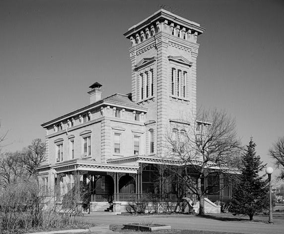
Rock_Island_Arsenal,_Building_No._1,_Gillespie_Avenue_between_Terrace_Drive_&_Hedge_Lane,_Rock_Island,(_Rock_Island_County,_Illinois).jpg (572 × 470 pixels, file size: 88 KB, MIME type: image/jpeg)
| This is a file from the Wikimedia Commons. Information from its description page there is shown below. Commons is a freely licensed media file repository. You can help. |
|
This is an image of a place or building that is listed on the National Register of Historic Places in the United States of America. Its reference number is 69000057. |
Summary
| DescriptionRock Island Arsenal, Building No. 1, Gillespie Avenue between Terrace Drive & Hedge Lane, Rock Island,( Rock Island County, Illinois).jpg | Rock Island Arsenal, Building No. 1, Gillespie Avenue between Terrace Drive & Hedge Lane, Rock Island,( Rock Island County, Illinois) (cropped) |
| Date | |
| Source | http://memory.loc.gov/cgi-bin/displayPhoto.pl?path=/pnp/habshaer/il/il0500/il0528/photos&topImages=063539pr.jpg&topLinks=063539pv.jpg,063539pu.tif&title=2.%20%203%2f4%20view%20of%20S%20%26%20E%20(front)%20elevations;%20looking%20NW.%20(Ceronie)%20%3cbr%3eHABS%20ILL,81-ROCIL,3%2f1-2&displayProfile=0 |
| Author | Robert A, Ryan, J. Ceronia, and Bruce A. Harms, Photographers |
| Permission (Reusing this file) |
HABS |
| Object location | 41° 30′ 58″ N, 90° 32′ 21″ W | View this and other nearby images on: OpenStreetMap |
|---|
Licensing

|
This file comes from the Historic American Buildings Survey (HABS), Historic American Engineering Record (HAER) or Historic American Landscapes Survey (HALS). These are programs of the National Park Service established for the purpose of documenting historic places. Records consist of measured drawings, archival photographs, and written reports.
This tag does not indicate the copyright status of the attached work. A normal copyright tag is still required. See Commons:Licensing. |
| Public domainPublic domainfalsefalse |
| This image or media file contains material based on a work of a National Park Service employee, created as part of that person's official duties. As a work of the U.S. federal government, such work is in the public domain in the United States. See the NPS website and NPS copyright policy for more information. |
Captions
Items portrayed in this file
depicts
March 1985
41°30'58.000"N, 90°32'21.001"W
File history
Click on a date/time to view the file as it appeared at that time.
| Date/Time | Thumbnail | Dimensions | User | Comment | |
|---|---|---|---|---|---|
| current | 23:56, 1 May 2008 | | 572 × 470 (88 KB) | KudzuVine | {{Information |Description=Rock Island Arsenal, Building No. 1, Gillespie Avenue between Terrace Drive & Hedge Lane, Rock Island,( Rock Island County, Illinois) (cropped) |Source=http://memory.loc.gov/cgi-bin/displayPhoto.pl?path=/pnp/habshaer/il/il0500/i |
File usage
Global file usage
The following other wikis use this file:
- Usage on de.wikipedia.org
- Usage on en.wikivoyage.org
- Usage on fr.wikipedia.org
- Usage on pt.wikipedia.org
- Usage on ru.wikipedia.org
- Usage on uk.wikipedia.org
- Usage on www.wikidata.org
Metadata
This file contains additional information, probably added from the digital camera or scanner used to create or digitize it.
If the file has been modified from its original state, some details may not fully reflect the modified file.
| Orientation | Normal |
|---|---|
| File change date and time | 19:51, 1 May 2008 |
| Unique image ID | FDA39C9329BA491B9A9CFCDE4AF0D447 |
.jpg)