File:Rheinbund_1806,_political_map.png
From Wikipedia, the free encyclopedia
Size of this preview: 507 × 600 pixels. Other resolutions: 203 × 240 pixels | 406 × 480 pixels | 649 × 768 pixels | 866 × 1,024 pixels | 2,414 × 2,855 pixels.
Original file (2,414 × 2,855 pixels, file size: 1.93 MB, MIME type: image/png)
| This is a file from the Wikimedia Commons. Information from its description page there is shown below. Commons is a freely licensed media file repository. You can help. |
Summary
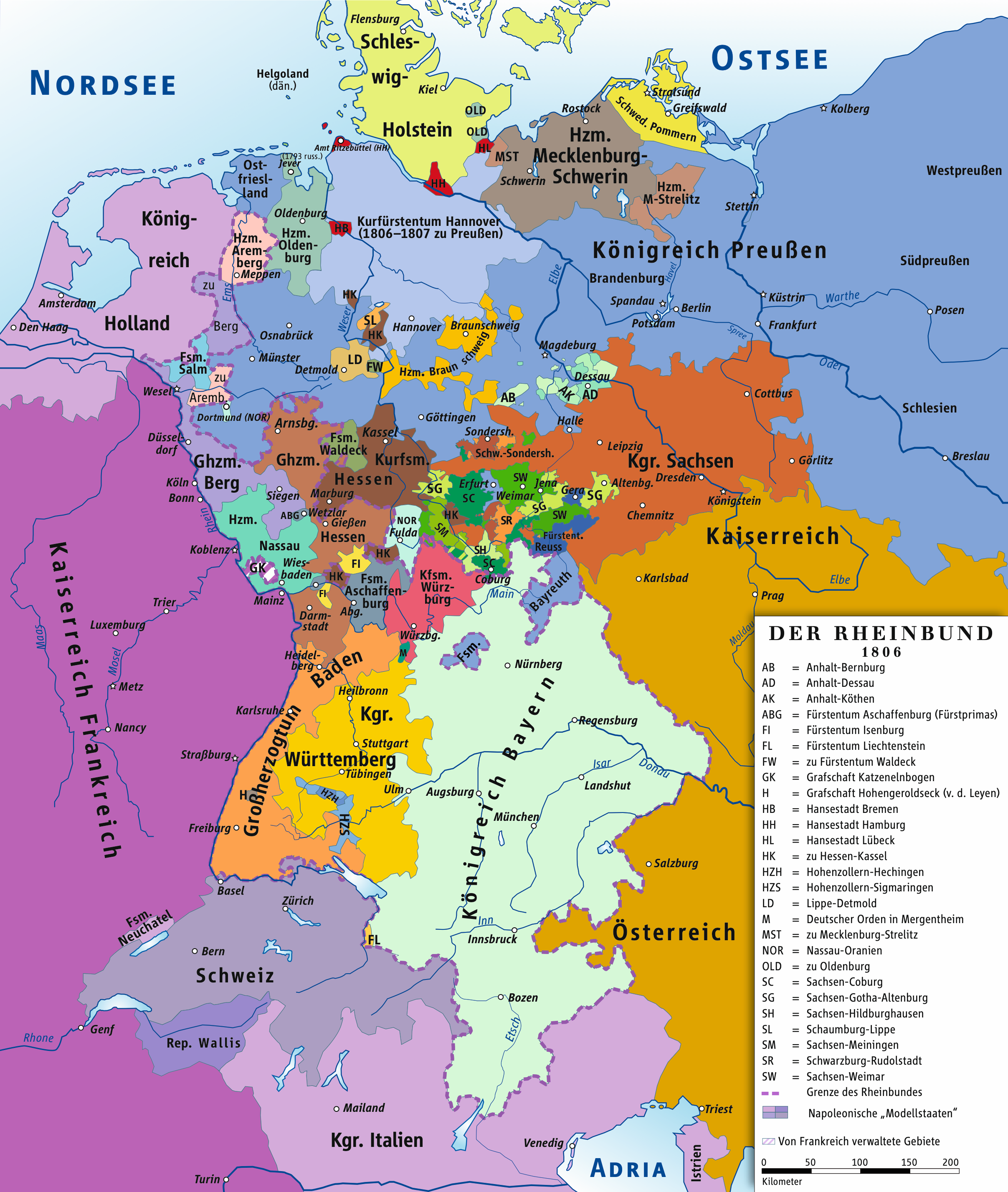
| DescriptionRheinbund 1806, political map.png |
Deutsch: Karte des Rheinbundes 1806 English: Map of the Confederation of the Rhine, 1806 |
| Date | |
| Source | own drawing/Source of Information: Putzger – Historischer Weltatlas, 89. Auflage, 1965; Westermanns Großer Atlas zur Weltgeschichte, 1969; Haacks geographischer Atlas. VEB Hermann Haack Geographisch-Kartographische Anstalt, Gotha/Leipzig, 1. Auflage, 1979. |
| Author | ziegelbrenner |
| Permission (Reusing this file) |
GNU FDL |

|
This map has been made or improved in the German Kartenwerkstatt (Map Lab). You can propose maps to improve as well.
azərbaycanca ∙ čeština ∙ Deutsch ∙ Deutsch (Sie-Form) ∙ English ∙ español ∙ français ∙ italiano ∙ latviešu ∙ magyar ∙ Nederlands ∙ Plattdüütsch ∙ polski ∙ português ∙ română ∙ sicilianu ∙ slovenščina ∙ suomi ∙ македонски ∙ русский ∙ ქართული ∙ հայերեն ∙ বাংলা ∙ ไทย ∙ +/−
|
Licensing
I, the copyright holder of this work, hereby publish it under the following licenses:

|
Permission is granted to copy, distribute and/or modify this document under the terms of the GNU Free Documentation License, Version 1.2 or any later version published by the Free Software Foundation; with no Invariant Sections, no Front-Cover Texts, and no Back-Cover Texts. A copy of the license is included in the section entitled GNU Free Documentation License.http://www.gnu.org/copyleft/fdl.htmlGFDLGNU Free Documentation Licensetruetrue |
| This file is licensed under the Creative Commons Attribution-Share Alike 3.0 Unported license. | ||
| ||
| This licensing tag was added to this file as part of the GFDL licensing update.http://creativecommons.org/licenses/by-sa/3.0/CC BY-SA 3.0Creative Commons Attribution-Share Alike 3.0truetrue |
This file is licensed under the Creative Commons Attribution 2.5 Generic license.
- You are free:
- to share – to copy, distribute and transmit the work
- to remix – to adapt the work
- Under the following conditions:
- attribution – You must give appropriate credit, provide a link to the license, and indicate if changes were made. You may do so in any reasonable manner, but not in any way that suggests the licensor endorses you or your use.
You may select the license of your choice.
Captions
Add a one-line explanation of what this file represents
Karte des Rheinbundes (1806)
Items portrayed in this file
depicts
19 January 2010
image/png
File history
Click on a date/time to view the file as it appeared at that time.
| Date/Time | Thumbnail | Dimensions | User | Comment | |
|---|---|---|---|---|---|
| current | 13:57, 24 October 2022 | | 2,414 × 2,855 (1.93 MB) | Ziegelbrenner | Städte wieder eingefügt |
| 13:36, 10 April 2019 |  | 2,414 × 2,854 (1.38 MB) | Ziegelbrenner | Ghzm. Würzburg | |
| 14:19, 1 August 2018 |  | 1,998 × 2,362 (13.51 MB) | Ziegelbrenner | Hessen-Kaselschen Anteil an Schaumburg nachgetragen | |
| 12:58, 31 July 2018 |  | 1,772 × 2,095 (10.63 MB) | Ziegelbrenner | Corrected Hannover + Amt Ritzebüttel | |
| 11:50, 14 February 2014 |  | 1,998 × 2,362 (1.13 MB) | Ziegelbrenner | 2014-02-14 | |
| 10:25, 3 February 2014 |  | 1,998 × 2,362 (1.97 MB) | Ziegelbrenner | 2014-02-03 | |
| 10:22, 3 February 2014 |  | 2,008 × 2,362 (1.85 MB) | Ziegelbrenner | Reverted to version as of 16:14, 30 January 2014 | |
| 13:28, 31 January 2014 |  | 507 × 599 (187 KB) | Ziegelbrenner | Reverted to version as of 16:03, 20 January 2014 Why did you revert this? New version has some corrections. | |
| 16:14, 30 January 2014 |  | 2,008 × 2,362 (1.85 MB) | Эрманарих | Reverted to version as of 14:53, 3 February 2011 | |
| 16:03, 20 January 2014 |  | 507 × 599 (187 KB) | Ziegelbrenner | 2014-01-20 |
File usage
The following pages on the English Wikipedia use this file (pages on other projects are not listed):
Global file usage
The following other wikis use this file:
- Usage on azb.wikipedia.org
- Usage on bar.wikipedia.org
- Usage on be.wikipedia.org
- Usage on ca.wikipedia.org
- Usage on cv.wikipedia.org
- Usage on de.wikipedia.org
- 1806
- Maximilian I. Joseph (Bayern)
- Friedrich Wilhelm III. (Preußen)
- Rheinbund
- Königreich Bayern
- Geschichte der Stadt Düsseldorf
- Rheinkrise
- Residenzstadt
- Vertrag von Schönbrunn
- Benutzer:TravenTorsvan/Baustelle/Babel
- Benutzer:Ziegelbrenner/Meine Bilder auf Commons
- Liste der Mitgliedstaaten im Rheinbund
- Wikipedia:Auskunft/Archiv/2014/Woche 47
- Vertrag von Paris (15. Februar 1806)
- Wikipedia:WikiProjekt Kategorien/Diskussionen/2023/August/12
- Wikipedia:Löschkandidaten/12. August 2023
- Usage on el.wikipedia.org
- Usage on eo.wikipedia.org
- Usage on es.wikipedia.org
- Usage on et.wikipedia.org
- Usage on fi.wikipedia.org
- Usage on fr.wikipedia.org
- Usage on he.wikipedia.org
- Usage on id.wikipedia.org
- Usage on it.wikipedia.org
- Usage on ja.wikipedia.org
- Usage on ko.wikipedia.org
- Usage on lv.wikipedia.org
- Usage on ms.wikipedia.org
- Usage on nl.wikipedia.org
- Usage on ru.wikipedia.org
- Usage on sh.wikipedia.org
- Usage on sl.wikipedia.org
- Usage on sv.wikipedia.org
View more global usage of this file.
Metadata
This file contains additional information, probably added from the digital camera or scanner used to create or digitize it.
If the file has been modified from its original state, some details may not fully reflect the modified file.
| Short title |
|
|---|---|
| Software used | Adobe Illustrator 24.2 (Macintosh) |
| Date and time of digitizing | 17:55, 19 August 2020 |
| File change date and time | 17:56, 24 October 2022 |
| Date metadata was last modified | 17:56, 24 October 2022 |
| Unique ID of original document | uuid:80696F872CD611DDAF2586899003A8DB |
| Horizontal resolution | 118.11 dpc |
| Vertical resolution | 118.11 dpc |
Retrieved from "https://en.wikipedia.org/wiki/File:Rheinbund_1806,_political_map.png"