File:Rancho_Omochumnes1844_map.jpg
From Wikipedia, the free encyclopedia
Size of this preview: 800 × 562 pixels. Other resolutions: 320 × 225 pixels | 640 × 450 pixels | 1,080 × 759 pixels.
Original file (1,080 × 759 pixels, file size: 143 KB, MIME type: image/jpeg)
| This is a file from the Wikimedia Commons. Information from its description page there is shown below. Commons is a freely licensed media file repository. You can help. |
Summary
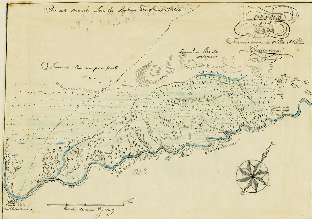
| DescriptionRancho Omochumnes1844 map.jpg |
English: 1844 Map of Diseño of Rancho Omochumnes, also called Rancho Río de los Cosumnes al Norte. A First Mexican Republic land grant, that was given to Jared Dixon Sheldon as payment for work done in Monterey on the Mexican Republic Custom House in 1843. |
| Date | |
| Source |
Original publication: First Mexican Republic |
| Author |
First Mexican Republic |
Licensing
| Public domainPublic domainfalsefalse |
This work is in the public domain in the United States because it was published (or registered with the U.S. Copyright Office) before January 1, 1929.
Public domain works must be out of copyright in both the United States and in the source country of the work in order to be hosted on the Commons. If the work is not a U.S. work, the file must have an additional copyright tag indicating the copyright status in the source country.
Note: This tag should not be used for sound recordings.PD-1923Public domain in the United States//commons.wikimedia.org/wiki/File:Rancho_Omochumnes1844_map.jpg |
Captions
Add a one-line explanation of what this file represents
Items portrayed in this file
depicts
1844
image/jpeg
File history
Click on a date/time to view the file as it appeared at that time.
| Date/Time | Thumbnail | Dimensions | User | Comment | |
|---|---|---|---|---|---|
| current | 22:01, 18 September 2023 | | 1,080 × 759 (143 KB) | Telecineguy | Uploading an old public-domain work using File Upload Wizard |
File usage
The following pages on the English Wikipedia use this file (pages on other projects are not listed):
Metadata
This file contains additional information, probably added from the digital camera or scanner used to create or digitize it.
If the file has been modified from its original state, some details may not fully reflect the modified file.
| Original transmission location code | 9ic2mW9uYomJQ9pCaJDi |
|---|---|
| Special instructions | FBMD0a000a860100007a240000d75c0000e55e0000a3610000e7c600002b420100fc4b01003a5101002f590100ec3d0200 |
Retrieved from "https://en.wikipedia.org/wiki/File:Rancho_Omochumnes1844_map.jpg"