File:Rail_transport_map_of_Turkey.png
From Wikipedia, the free encyclopedia
Size of this preview: 800 × 383 pixels. Other resolutions: 320 × 153 pixels | 640 × 306 pixels | 1,024 × 490 pixels | 1,280 × 613 pixels | 3,656 × 1,750 pixels.
Original file (3,656 × 1,750 pixels, file size: 789 KB, MIME type: image/png)
| This is a file from the Wikimedia Commons. Information from its description page there is shown below. Commons is a freely licensed media file repository. You can help. |

|
This transport map image could be re-created using vector graphics as an SVG file. This has several advantages; see Commons:Media for cleanup for more information. If an SVG form of this image is available, please upload it and afterwards replace this template with
{{vector version available|new image name}}.
It is recommended to name the SVG file “Rail transport map of Turkey.svg”—then the template Vector version available (or Vva) does not need the new image name parameter. |
Summary
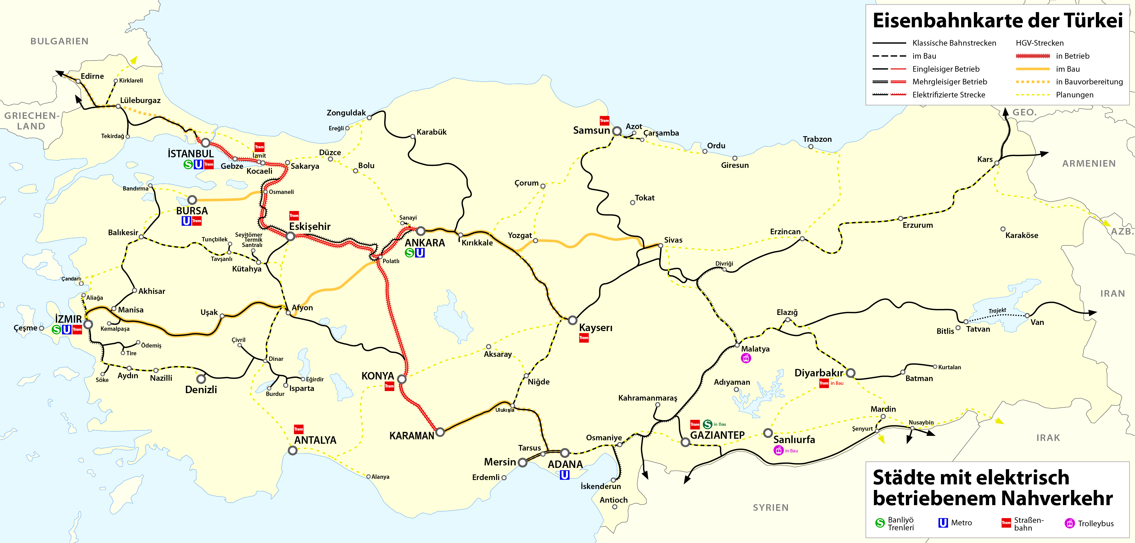
| DescriptionRail transport map of Turkey.png |
Deutsch: Eisenbahnkarte der Türkei
English: Railway map of Turkey
Français : Carte des chemins de fer de la Turquie |
| Date | see file history |
| Source | Own work |
| Author | Maximilian Dörrbecker (Chumwa) |
| Permission (Reusing this file) |
I, the copyright holder of this work, hereby publish it under the following license: This file is licensed under the Creative Commons Attribution-Share Alike 2.5 Generic license.
Sie dürfen das Bild zu den folgenden Bedingungen nutzen:
|
Captions
Add a one-line explanation of what this file represents
Items portrayed in this file
depicts
image/png
File history
Click on a date/time to view the file as it appeared at that time.
| Date/Time | Thumbnail | Dimensions | User | Comment | |
|---|---|---|---|---|---|
| current | 16:40, 9 March 2022 | | 3,656 × 1,750 (789 KB) | Rcsprinter123 | . |
| 13:50, 22 January 2022 |  | 3,656 × 1,750 (788 KB) | Rcsprinter123 | Konya-Karaman high speed rail line was opened on 8 January 2022 | |
| 23:11, 10 November 2018 |  | 3,656 × 1,750 (721 KB) | BRKY24 | Karaman- Ulukisla High Speed construction underway. Plan to connect Candarli Port to commuter rail network at Bergama and connecting both to national grid at Soma under project. Kars-Tbilisi-Baku electrified network in function both for passengers and freight. Gaziantep's commuter rail network Gaziray soon to be finalized. | |
| 20:06, 17 June 2017 |  | 3,656 × 1,750 (686 KB) | Chumwa | update | |
| 21:40, 28 June 2016 |  | 3,656 × 1,750 (684 KB) | Chumwa | Tram Izmit in Bau | |
| 16:11, 12 May 2016 |  | 3,656 × 1,750 (461 KB) | Kopiersperre | optipng | |
| 03:39, 12 May 2016 |  | 3,656 × 1,750 (683 KB) | Chumwa | ||
| 20:27, 9 May 2016 |  | 3,656 × 1,750 (680 KB) | Chumwa | == {{int:filedesc}} == {{Information |Description= {{ de| Eisenbahnkarte der Türkei }} {{ en| Railway map of Turkey }} {{ fr| Carte des chemins de fer de la Turquie }} |Source=Self made |Date=see file history |Author= [[:de:User:Chumwa|Maximilian Dör... |
File usage
The following pages on the English Wikipedia use this file (pages on other projects are not listed):
- Ankara Tren Garı
- Ankara–Istanbul high-speed railway
- Ankara–Sivas high-speed railway
- Bilecik YHT railway station
- Bozüyük YHT railway station
- Cilicia
- High-speed rail in Europe
- High-speed rail in Turkey
- Istanbul–Kapıkule railway
- List of railway lines in Turkey
- Marşandiz train collision
- Mersin–Adana–Gaziantep railway
- Nurdağı–Başpınar railway
- Polatlı YHT railway station
- Polatlı–Konya high-speed railway
- Polatlı–İzmir high-speed railway
- TCDD HT65000
- TCDD HT80000
- Transport in Turkey
- Turkish State Railways
- Yüksek Hızlı Tren
- User:Central Data Bank/Turkish State Railways
- Wikipedia:Graphics Lab/Map workshop/Archive/Aug 2023
- Wikipedia:Graphics Lab/Map workshop/Archive/Mar 2021
- Template:High-speed rail in Turkey
Global file usage
The following other wikis use this file:
- Usage on ar.wikipedia.org
- Usage on az.wikipedia.org
- Usage on bg.wikipedia.org
- Usage on bs.wikipedia.org
- Usage on cs.wikipedia.org
- Usage on de.wikipedia.org
- Schnellfahrstrecke
- Benutzer:Chumwa
- Türkiye Cumhuriyeti Devlet Demiryolları
- Schienenverkehr in der Türkei
- Liste der Eisenbahnstrecken in der Türkei
- Hochgeschwindigkeitsstrecke Ankara–İstanbul
- Hochgeschwindigkeitsstrecke Ankara–Konya
- Hochgeschwindigkeitsstrecke Ankara–Sivas
- Benutzer:Pechristener/Baustelle2
- Benutzer:Chumwa/SomeOfMyFiles
- Schnellfahrstrecke Halkalı–Kapıkule
- Usage on el.wikivoyage.org
- Usage on es.wikipedia.org
- Usage on es.wikivoyage.org
- Usage on fa.wikipedia.org
- Usage on fr.wikipedia.org
- Usage on fr.wikivoyage.org
- Usage on he.wikipedia.org
- Usage on hu.wikipedia.org
- Törökország közlekedése
- Törökország vasúti közlekedése
- Nagysebességű vasútvonalak Európában
- Nagysebességű vasútvonalak listája
- Törökország nagysebességű vasúti közlekedése
- Török Államvasutak
- Isztambul–Ankara nagysebességű vasútvonal
- Ankara–Konya nagysebességű vasútvonal
- Sablon:Törökország nagysebességű vasúti közlekedése
- TCDD HT80000 sorozat
- Usage on id.wikipedia.org
- Usage on it.wikipedia.org
- Usage on it.wikivoyage.org
- Usage on ja.wikipedia.org
- Usage on ka.wikipedia.org
- Usage on meta.wikimedia.org
- Usage on nl.wikipedia.org
View more global usage of this file.
Metadata
This file contains additional information, probably added from the digital camera or scanner used to create or digitize it.
If the file has been modified from its original state, some details may not fully reflect the modified file.
| Horizontal resolution | 37.8 dpc |
|---|---|
| Vertical resolution | 37.8 dpc |
| Software used |
Retrieved from "https://en.wikipedia.org/wiki/File:Rail_transport_map_of_Turkey.png"