File:Rail_density_map.png
From Wikipedia, the free encyclopedia
Size of this preview: 800 × 370 pixels. Other resolutions: 320 × 148 pixels | 640 × 296 pixels | 1,350 × 625 pixels.
Original file (1,350 × 625 pixels, file size: 49 KB, MIME type: image/png)
| This is a file from the Wikimedia Commons. Information from its description page there is shown below. Commons is a freely licensed media file repository. You can help. |
Summary

|
File:Rail density map.svg is a vector version of this file. It should be used in place of this PNG file when not inferior.
File:Rail density map.png → File:Rail density map.svg
For more information, see Help:SVG.
|
 |
| DescriptionRail density map.png |
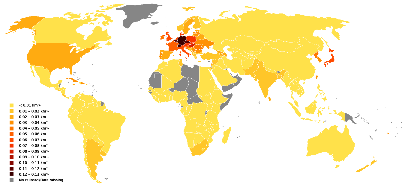
English: Blank world template from Wikimedia Commons, data from en:List of countries by rail transport network size and en:Countries_by_area
Compiled by en:User:GSchjetne
Deutsch: Dichte des Schienennetzes in km Schiene pro km² Fläche. |
| Date | 2 June 2006 (original upload date) |
| Source | Transferred from en.wikipedia to Commons by Tam0031 using CommonsHelper. |
| Author | GSchjetne at English Wikipedia |
Licensing
| Public domainPublic domainfalsefalse |
| This work has been released into the public domain by its author, GSchjetne. This applies worldwide. In some countries this may not be legally possible; if so: |
Original upload log
The original description page was here. All following user names refer to en.wikipedia.
- 2006-06-02 11:05 GSchjetne 1350×625×8 (21335 bytes) Blank world template from Wikimedia Commons, data from [[List of countries by rail transport network size]] and [[Countries_by_area]] Compiled by [[User:GSchjetne]]
Captions
Color-coded map of rail density by country.
Items portrayed in this file
depicts
2 June 2006
image/png
File history
Click on a date/time to view the file as it appeared at that time.
| Date/Time | Thumbnail | Dimensions | User | Comment | |
|---|---|---|---|---|---|
| current | 12:12, 1 October 2018 | | 1,350 × 625 (49 KB) | A2D2 | Fixed Iraq and Uganda. |
| 18:12, 25 March 2018 |  | 1,350 × 625 (49 KB) | Maphobbyist | Montenegro and South Sudan borders | |
| 14:29, 15 December 2017 |  | 1,350 × 625 (49 KB) | A2D2 | Mongolia | |
| 19:42, 24 June 2013 |  | 1,350 × 625 (21 KB) | ProfesorFavalli | Added Tierra del Fuego Province (Argentina). | |
| 22:13, 16 November 2011 |  | 1,350 × 625 (21 KB) | McZusatz | darker | |
| 03:48, 5 July 2008 |  | 1,350 × 625 (21 KB) | File Upload Bot (Magnus Manske) | {{BotMoveToCommons|en.wikipedia}} {{Information |Description={{en|Blank world template from Wikimedia Commons, data from en:List of countries by rail transport network size and en:Countries_by_area Compiled by en:User:GSchjetne}} |Source=T |
File usage
No pages on the English Wikipedia use this file (pages on other projects are not listed).
Global file usage
The following other wikis use this file:
- Usage on de.wikipedia.org
- Usage on de.wikiversity.org
- Usage on pnb.wikipedia.org
- Usage on te.wikipedia.org
- Usage on uk.wikipedia.org
- Usage on ur.wikipedia.org
Metadata
This file contains additional information, probably added from the digital camera or scanner used to create or digitize it.
If the file has been modified from its original state, some details may not fully reflect the modified file.
| Horizontal resolution | 37.8 dpc |
|---|---|
| Vertical resolution | 37.8 dpc |
Retrieved from "https://en.wikipedia.org/wiki/File:Rail_density_map.png"