File:Quercus_macrocarpa_range_map_1.png
From Wikipedia, the free encyclopedia
Original file (2,048 × 2,048 pixels, file size: 135 KB, MIME type: image/png)
| This is a file from the Wikimedia Commons. Information from its description page there is shown below. Commons is a freely licensed media file repository. You can help. |
Summary
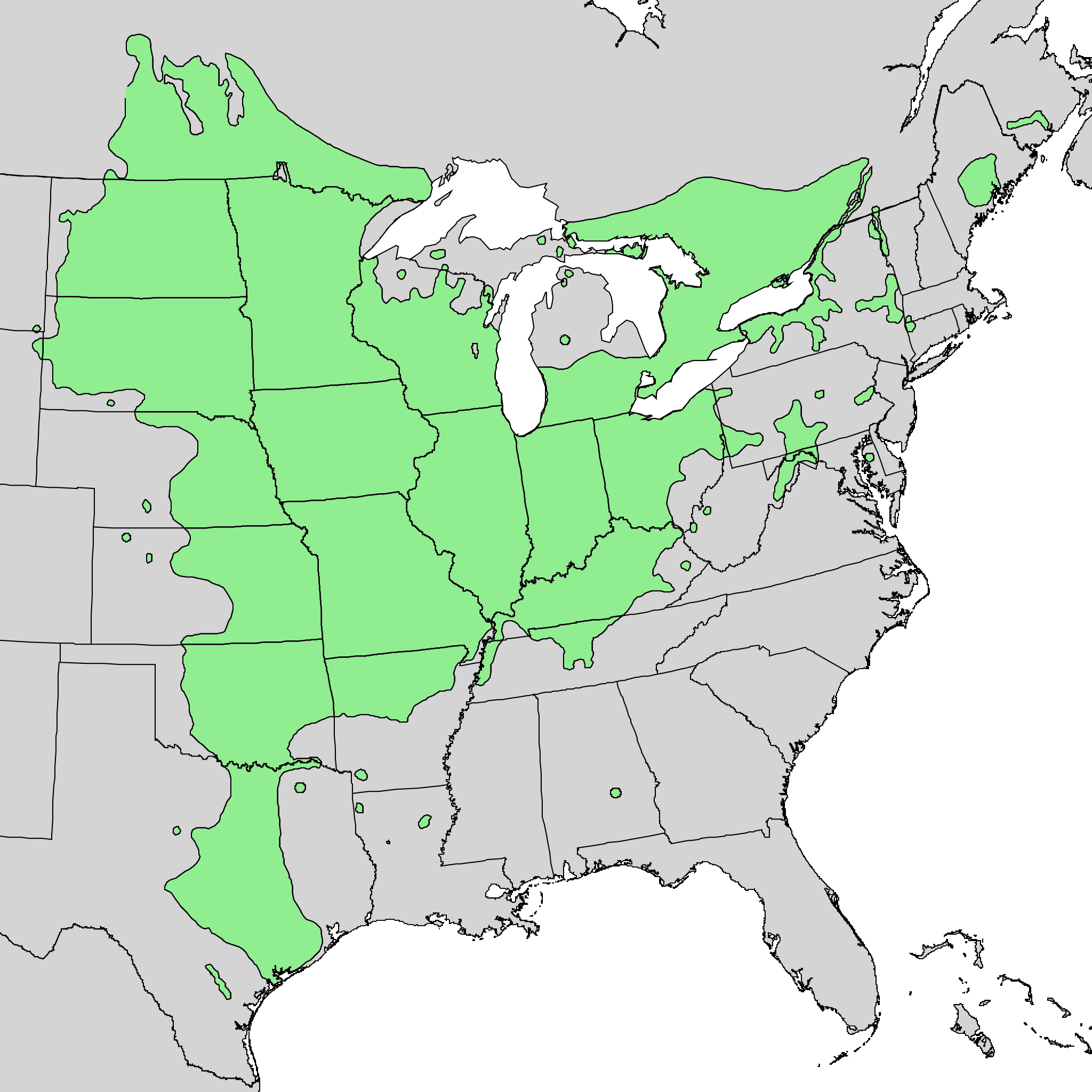
| DescriptionQuercus macrocarpa range map 1.png |
English: Range map of Quercus macrocarpa. |
| Date | |
| Source | Digital representation of "Atlas of United States Trees" by Elbert L. Little, Jr. [1] |
| Author | U.S. Geological Survey |
Licensing
| Public domainPublic domainfalsefalse |
This image is in the public domain in the United States because it only contains materials that originally came from the United States Geological Survey, an agency of the United States Department of the Interior. For more information, see the official USGS copyright policy.
Bahasa Indonesia ∙ català ∙ čeština ∙ Deutsch ∙ eesti ∙ English ∙ español ∙ français ∙ galego ∙ italiano ∙ Nederlands ∙ português ∙ polski ∙ sicilianu ∙ suomi ∙ Tiếng Việt ∙ Türkçe ∙ български ∙ македонски ∙ русский ∙ മലയാളം ∙ 한국어 ∙ 日本語 ∙ 中文 ∙ 中文(简体) ∙ 中文(繁體) ∙ العربية ∙ فارسی ∙ +/− |
Original upload log
Transferred from en.wikipedia to Commons by Quadell using CommonsHelper.
- 2010-05-21 03:22 Masebrock 743×612× (139721 bytes) {{Information |Description=Range map of Quercus marcocarpa |Source=Digital representation of "Atlas of United States Trees" by Elbert L. Little, Jr. [http://esp.cr.usgs.gov/data/atlas/little/] |Date=1999 |Author=U.S. Geological Survey |Permission={{PD-US
File history
Click on a date/time to view the file as it appeared at that time.
| Date/Time | Thumbnail | Dimensions | User | Comment | |
|---|---|---|---|---|---|
| current | 20:40, 20 October 2013 | | 2,048 × 2,048 (135 KB) | Nonenmac | Doubled the resolution so that more of the little green circles contain green instead of just black |
| 14:47, 18 October 2013 |  | 1,024 × 1,024 (45 KB) | Nonenmac | larger png version without the vertical striping, directly from the same USGS source | |
| 20:43, 7 September 2011 |  | 743 × 612 (136 KB) | File Upload Bot (Magnus Manske) | {{BotMoveToCommons|en.wikipedia|year={{subst:CURRENTYEAR}}|month={{subst:CURRENTMONTHNAME}}|day={{subst:CURRENTDAY}}}} {{Information |Description={{en|Range map of Quercus marcocarpa}} |Source=Transferred from [http://en.wikipedia.org en.wikipedia]; tran |
File usage
Global file usage
The following other wikis use this file:
- Usage on ar.wikipedia.org
- Usage on arz.wikipedia.org
- Usage on ca.wikipedia.org
- Usage on ceb.wikipedia.org
- Usage on cs.wikipedia.org
- Usage on es.wikipedia.org
- Usage on fa.wikipedia.org
- Usage on hu.wikipedia.org
- Usage on is.wikipedia.org
- Usage on it.wikipedia.org
- Usage on ka.wikipedia.org
- Usage on no.wikipedia.org
- Usage on pl.wikipedia.org
- Usage on ru.wikipedia.org
- Usage on sv.wikipedia.org
- Usage on uk.wikipedia.org
- Usage on vi.wikipedia.org
- Usage on www.wikidata.org
- Usage on zh.wikipedia.org
Metadata
This file contains additional information, probably added from the digital camera or scanner used to create or digitize it.
If the file has been modified from its original state, some details may not fully reflect the modified file.
| Date and time of digitizing | 12:38, 20 October 2013 |
|---|---|
| File change date and time | 12:38, 20 October 2013 |
| Date metadata was last modified | 12:38, 20 October 2013 |
| Software used |