File:Quay_Street,_Ammanford_(Recreated)_-_geograph.org.uk_-_299161.jpg
From Wikipedia, the free encyclopedia
No higher resolution available.
Quay_Street,_Ammanford_(Recreated)_-_geograph.org.uk_-_299161.jpg (640 × 451 pixels, file size: 86 KB, MIME type: image/jpeg)
| This is a file from the Wikimedia Commons. Information from its description page there is shown below. Commons is a freely licensed media file repository. You can help. |
Summary
| DescriptionQuay Street, Ammanford (Recreated) - geograph.org.uk - 299161.jpg |
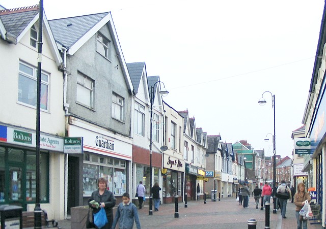
English: Quay Street, Ammanford (Recreated) Another shot of Quay Street recreated from the Frith collection.
This time it is a 1936 shot ( http://www.francisfrith.com/search/wales/dyfed/ammanford/photos/ammanford_87811.htm ) of the west side of the street running from south of where Hall Street joins it, up to the town square. The roof line is much the same in both shots, but the modern buildings have lost all their bay windows and awnings. |
| Date | |
| Source | From geograph.org.uk |
| Author | Nigel Davies |
| Attribution (required by the license) InfoField | Nigel Davies / Quay Street, Ammanford (Recreated) / |
InfoField | Nigel Davies / Quay Street, Ammanford (Recreated) |
| Object location | 51° 47′ 30.4″ N, 3° 59′ 15″ W | View this and other nearby images on: OpenStreetMap |
|---|
Licensing

|
This image was taken from the Geograph project collection. See this photograph's page on the Geograph website for the photographer's contact details. The copyright on this image is owned by Nigel Davies and is licensed for reuse under the Creative Commons Attribution-ShareAlike 2.0 license.
|
This file is licensed under the Creative Commons Attribution-Share Alike 2.0 Generic license.
Attribution: Nigel Davies
- You are free:
- to share – to copy, distribute and transmit the work
- to remix – to adapt the work
- Under the following conditions:
- attribution – You must give appropriate credit, provide a link to the license, and indicate if changes were made. You may do so in any reasonable manner, but not in any way that suggests the licensor endorses you or your use.
- share alike – If you remix, transform, or build upon the material, you must distribute your contributions under the same or compatible license as the original.
Captions
Add a one-line explanation of what this file represents
Items portrayed in this file
depicts
some value
24 December 2006
51°47'30.37"N, 3°59'15.00"W
File history
Click on a date/time to view the file as it appeared at that time.
| Date/Time | Thumbnail | Dimensions | User | Comment | |
|---|---|---|---|---|---|
| current | 21:44, 14 December 2010 | | 640 × 451 (86 KB) | GeographBot | == {{int:filedesc}} == {{Information |description={{en|1=Quay Street, Ammanford (Recreated) Another shot of Quay Street recreated from the Frith collection. This time it is a 1936 shot ( http://www.francisfrith.com/search/wales/dyfed/ammanford/photos/amm |
File usage
The following pages on the English Wikipedia use this file (pages on other projects are not listed):
Global file usage
The following other wikis use this file:
- Usage on cs.wikipedia.org
- Usage on eu.wikipedia.org
- Usage on fa.wikipedia.org
- Usage on fi.wikipedia.org
- Usage on gd.wikipedia.org
- Usage on kw.wikipedia.org
- Usage on nl.wikipedia.org
- Usage on ru.wikipedia.org
- Usage on simple.wikipedia.org
Metadata
This file contains additional information, probably added from the digital camera or scanner used to create or digitize it.
If the file has been modified from its original state, some details may not fully reflect the modified file.
| _error | 0 |
|---|
_-_geograph.org.uk_-_299161.jpg)