File:Quad_Flandria.jpg
From Wikipedia, the free encyclopedia
Original file (3,345 × 2,498 pixels, file size: 7.53 MB, MIME type: image/jpeg)
| This is a file from the Wikimedia Commons. Information from its description page there is shown below. Commons is a freely licensed media file repository. You can help. |
Summary
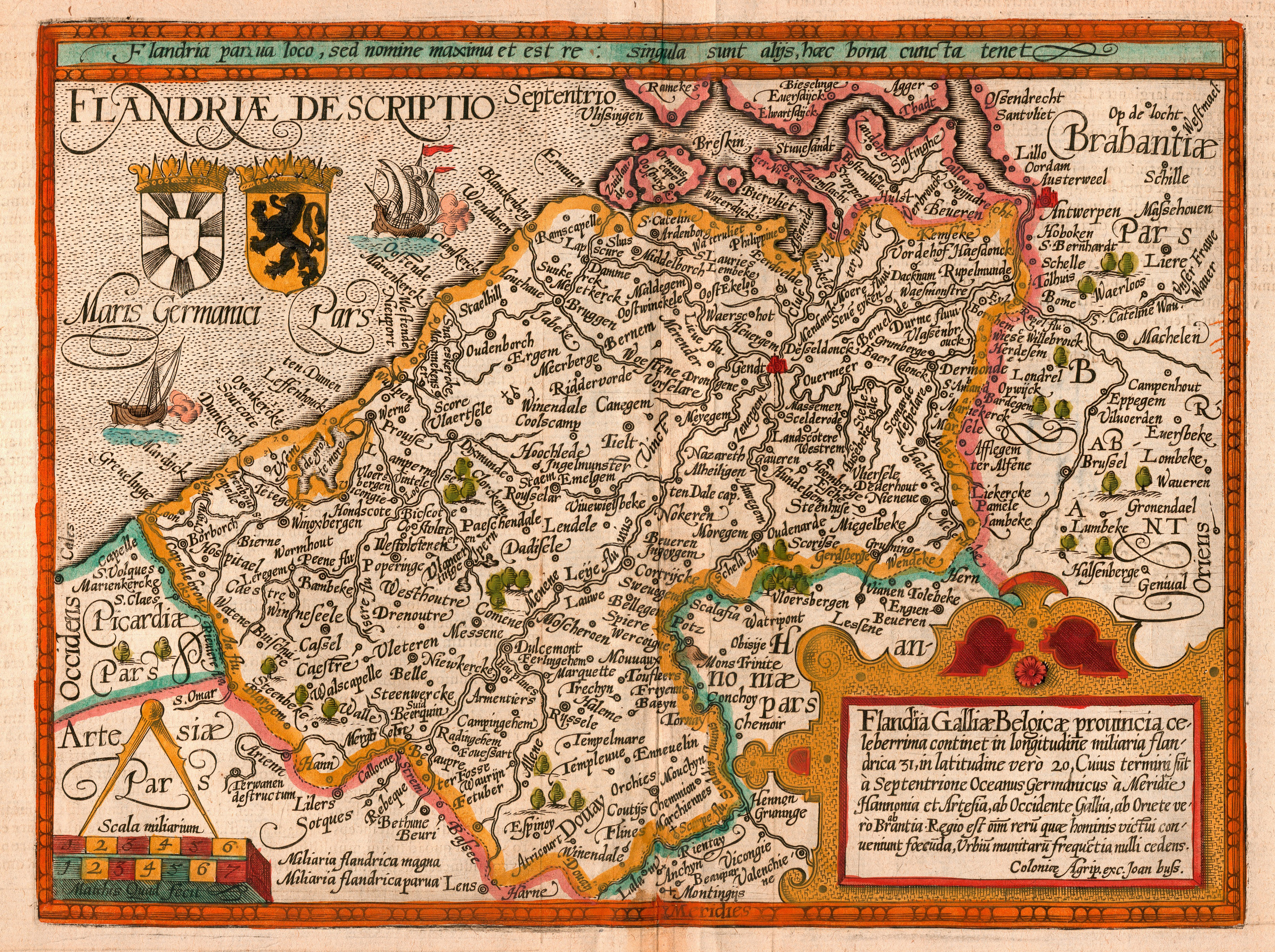
| DescriptionQuad Flandria.jpg |
English: Map of the county of Flanders by Matthias Quad (cartographer) and Johannes Bussemacher (engraver & publisher, Cologne)
Nederlands: Kaart van het graafschap Vlaanderen door Matthias Quad (kartograaf) en Johannes Bussemacher (graveur en uitgever, Keulen)
Français : Carte du comté de Flandre par Matthias Quad (cartographe) et Johannes Bussemacher (graveur et éditeur, Cologne)
Español: Mapa del condado de Flandes, de Matthias Quad (cartógrafo) y Johannes Bussemacher (grabador y editor, Colonia, Alemania) |
||||||||||||||||||||||
| Date | |||||||||||||||||||||||
| Source | eigen werk (scan) | ||||||||||||||||||||||
| Creator |
creator QS:P170,Q325618 and Johannes Bussemacherscanned by Marc Ryckaert (MJJR) |
||||||||||||||||||||||
| Permission (Reusing this file) |
|
||||||||||||||||||||||
| Georeferencing | Georeference the map in Wikimaps Warper If inappropriate please set warp_status = skip to hide. | ||||||||||||||||||||||
|

This image was selected as picture of the day on Wikimedia Commons for 6 May 2008. It was captioned as follows: English: Map of the county of Flanders by 1609 Other languages:
Alemannisch: Charte vo Flandern (Belgiä) us em Jahr 1609. Bosanski: Karta Grofovije Flandrija iz 1609. Čeština: Mapa Vévodství Flandry z roku 1609 Dansk: Kort over Flandern (Belgien) i 1609. Deutsch: Karte von Flandern (Belgien) aus dem Jahre 1609. English: Map of the county of Flanders by 1609 Français : Carte de la Flandre Íslenska: Kort af Flandri árið 1609. Italiano: Mappa delle Fiandre del 1609. Magyar: Flandria térképe 1609-ből, Matthias Quad térképész és Johannes Bussemacher grafikus és kiadó (Köln) munkája Polski: Mapa hrabstwa Flandrii wykonana około roku 1609. Svenska: Grevskapet Flandern på en karta från 1609. Türkçe: Flanders kontluğunun 1609'daki haritası Беларуская: Карта Фландрыі (1609) Русский: Карта Фландрии 1609 года Српски / srpski: Мапа Фландрије из 1609. године. Українська: Карта Фландрії 1609 року 한국어: 1609년에 그려진 플란데런 지도. 日本語: 1609年のフランドル地域の地図 中文: 佛兰德伯国1609年地图 中文(繁體): 佛蘭德伯國1609年地圖 العربية : خريطة دولة فلندرز عام 1609. فارسی : نقشه کشور فلندرز در 1609 |
Captions
Items portrayed in this file
depicts
File history
Click on a date/time to view the file as it appeared at that time.
| Date/Time | Thumbnail | Dimensions | User | Comment | |
|---|---|---|---|---|---|
| current | 20:26, 19 February 2008 | | 3,345 × 2,498 (7.53 MB) | MJJR | {{Information |Description= {{en|Map of the county of Flanders by Matthias Quad (cartographer) and Johannes Bussemacher (engraver & publisher, Cologne)}} {{nl|Kaart van het graafschap Vlaanderen door Matthias Quad (kartograaf) en Johannes Bussemacher (gra |
| 21:52, 17 February 2008 |  | 3,345 × 2,498 (7.47 MB) | MJJR | {{Information |Description= {{en|Map of the county of Flanders by Matthias Quad (cartographer) and Johannes Bussemacher (engraver & publisher, Cologne)}} {{nl|Kaart van het graafschap Vlaanderen door Matthias Quad (kartograaf) en Johannes Bussemacher (gra |
File usage
Global file usage
The following other wikis use this file:
- Usage on af.wikipedia.org
- Usage on ast.wikipedia.org
- Usage on azb.wikipedia.org
- Usage on be-tarask.wikipedia.org
- Usage on be.wikipedia.org
- Usage on bg.wikipedia.org
- Usage on bn.wikipedia.org
- Usage on br.wiktionary.org
- Usage on ca.wikipedia.org
- Usage on crh.wikipedia.org
- Usage on cv.wikipedia.org
- Usage on da.wikipedia.org
- Usage on de.wikipedia.org
- Usage on el.wikipedia.org
- Usage on es.wikipedia.org
- Usage on et.wikipedia.org
- Usage on frp.wikipedia.org
- Usage on fr.wikipedia.org
- Flandre (Belgique)
- Comté de Flandre
- Ledringhem
- Histoire de Tournai
- Wikipédia:Image du jour/mai 2008
- Wikipédia:Image du jour/6 mai 2008
- Adinkerque
- Maison de Lalaing
- Portail:Flandre-Orientale
- Portail:Flandre-Orientale/Sélection
- Portail:Flandres
- Portail:Flandres/Géographie
- Portail:Flandre-Occidentale
- Portail:Flandre-Occidentale/Sélection
- Flandre (terminologie)
View more global usage of this file.
Metadata
This file contains additional information, probably added from the digital camera or scanner used to create or digitize it.
If the file has been modified from its original state, some details may not fully reflect the modified file.
| Orientation | Normal |
|---|---|
| Horizontal resolution | 300 dpi |
| Vertical resolution | 300 dpi |
| Software used | Adobe Photoshop 7.0 |
| File change date and time | 21:18, 19 February 2008 |
| Color space | Uncalibrated |