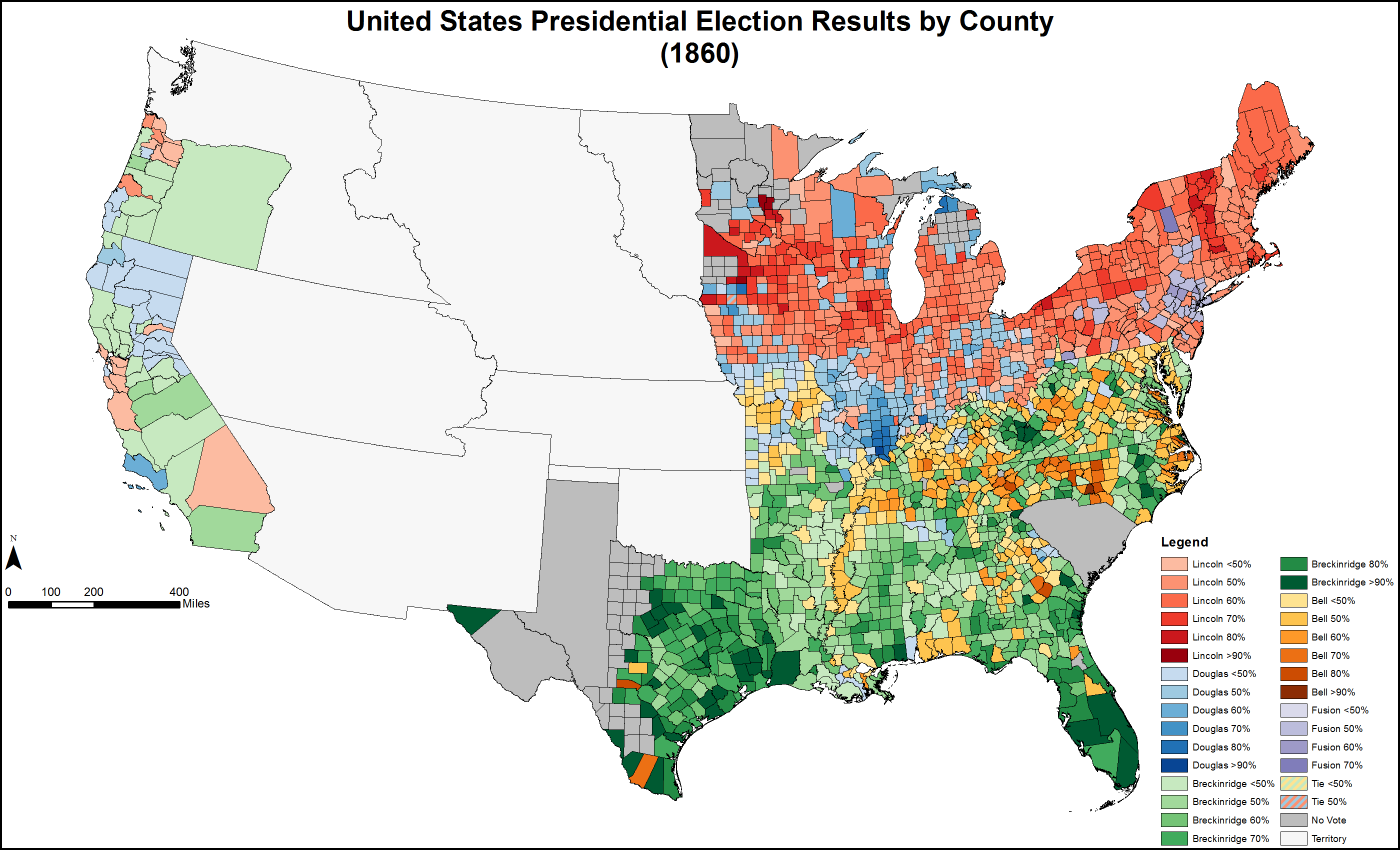
File:PresidentialCounty1860Colorbrewer.gif
From Wikipedia, the free encyclopedia
Original file (2,800 × 1,700 pixels, file size: 190 KB, MIME type: image/gif)
| This is a file from the Wikimedia Commons. Information from its description page there is shown below. Commons is a freely licensed media file repository. You can help. |
Summary
| DescriptionPresidentialCounty1860Colorbrewer.gif |
English: Presidential election results by county (1860). Colors based on Colorbrewer 2.0. |
|||
| Date | ||||
| Source |
Own work. Original shapefile downloaded from: Minnesota Population Center. National Historical Geographic Information System: Version 2.0. Minneapolis, MN: University of Minnesota 2011. http://www.nhgis.org |
|||
| Author |
|
|||
| Permission (Reusing this file) |
"Citation and Use of NHGIS Data All persons are granted a limited license to use this documentation and the accompanying data, subject to the following condition: Publications and research reports based on the database must cite it appropriately. The citation should include the following: Minnesota Population Center. National Historical Geographic Information System: Version 2.0. Minneapolis, MN: University of Minnesota 2011. If possible, citations should also include the URL for the NHGIS site: http://www.nhgis.org"
|

Licensing
- You are free:
- to share – to copy, distribute and transmit the work
- to remix – to adapt the work
- Under the following conditions:
- attribution – You must give appropriate credit, provide a link to the license, and indicate if changes were made. You may do so in any reasonable manner, but not in any way that suggests the licensor endorses you or your use.
- share alike – If you remix, transform, or build upon the material, you must distribute your contributions under the same or compatible license as the original.
Captions
Items portrayed in this file
depicts
5 July 2013
File history
Click on a date/time to view the file as it appeared at that time.
| Date/Time | Thumbnail | Dimensions | User | Comment | |
|---|---|---|---|---|---|
| current | 02:22, 10 February 2016 | | 2,800 × 1,700 (190 KB) | Tilden76 | South Carolina fixed |
| 02:07, 10 February 2016 |  | 2,800 × 1,700 (192 KB) | Tilden76 | Kentucky fixed | |
| 05:16, 5 February 2016 |  | 2,800 × 1,700 (192 KB) | Tilden76 | New format | |
| 19:51, 5 July 2013 |  | 2,800 × 2,200 (232 KB) | Tilden76 | User created page with UploadWizard |
File usage
Global file usage
The following other wikis use this file:
- Usage on es.wikipedia.org
- Usage on he.wikipedia.org
- Usage on it.wikipedia.org
- Usage on la.wikipedia.org
- Usage on vi.wikipedia.org
Metadata
This file contains additional information, probably added from the digital camera or scanner used to create or digitize it.
If the file has been modified from its original state, some details may not fully reflect the modified file.
| GIF file comment | Generated by Esri ArcMap 2004 |
|---|