File:Plansee.jpg
From Wikipedia, the free encyclopedia
Size of this preview: 800 × 521 pixels. Other resolutions: 320 × 208 pixels | 640 × 417 pixels | 1,024 × 667 pixels.
Original file (1,024 × 667 pixels, file size: 272 KB, MIME type: image/jpeg)
| This is a file from the Wikimedia Commons. Information from its description page there is shown below. Commons is a freely licensed media file repository. You can help. |
| DescriptionPlansee.jpg |
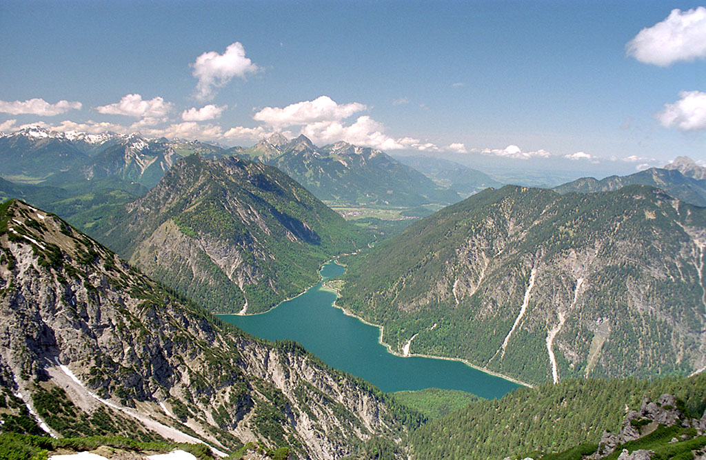
Deutsch: Plansee, Österreich, Bezirk Reutte, von Südosten, in der Mitte der Abfluss durch den Kleinen Plansee bzw. den Archbach in Richtung Lechtal.
Im Hintergrund links ein Teil des Hauptkamms der Allgäuer Alpen mit den Krottenköpfen (2180m), Leilachspitze (2274m), Lachenspitze (2130m), Schochenspitze (2069m), Sulzspitze (2084m) und Litnisschrofen (2069m). In der Hintergrundmitte die Tannheimer Berge mit Kellenspitze (2238m), Gehrenspitze (2163m) und Hahleskopf (1758m). Am rechten Bildrand ist der Säuling (2048m) zu sehen. Der Bildmittelgrund zeigt links über dem Seeufer den Tauern-Gipfel (1841m), rechts Schelleleskopf (1722m) und Hochjoch (1823m)
Башҡортса: Планзее күле.
Dansk: Plansee set fra sydøst. Archbachs udspring ses i midten.
Հայերեն: Պլանզեե լիճ.
Русский: Озеро Планзее. |
| Date | |
| Source | Own work |
| Author | Kogo |
| Permission (Reusing this file) |
Kogo put it under the GFDL |
| Camera location | 47° 27′ 40.5″ N, 10° 50′ 03.48″ E | View this and other nearby images on: OpenStreetMap |
|---|

|
Permission is granted to copy, distribute and/or modify this document under the terms of the GNU Free Documentation License, Version 1.2 or any later version published by the Free Software Foundation; with no Invariant Sections, no Front-Cover Texts, and no Back-Cover Texts. A copy of the license is included in the section entitled GNU Free Documentation License.http://www.gnu.org/copyleft/fdl.htmlGFDLGNU Free Documentation Licensetruetrue |
| Annotations InfoField | This image is annotated: View the annotations at Commons |
Captions
Add a one-line explanation of what this file represents
Items portrayed in this file
depicts
30 April 2002
47°27'40.50"N, 10°50'3.48"E
image/jpeg
File history
Click on a date/time to view the file as it appeared at that time.
| Date/Time | Thumbnail | Dimensions | User | Comment | |
|---|---|---|---|---|---|
| current | 00:16, 12 February 2005 | | 1,024 × 667 (272 KB) | Kogo | Plansee |
File usage
The following pages on the English Wikipedia use this file (pages on other projects are not listed):
Global file usage
The following other wikis use this file:
- Usage on arz.wikipedia.org
- Usage on ba.wikipedia.org
- Usage on ceb.wikipedia.org
- Usage on da.wikipedia.org
- Usage on de.wikipedia.org
- Usage on et.wikipedia.org
- Usage on fr.wikipedia.org
- Usage on hy.wikipedia.org
- Usage on nl.wikipedia.org
- Usage on ro.wikipedia.org
- Usage on ru.wikipedia.org
- Usage on sv.wikipedia.org
- Usage on www.wikidata.org
- Usage on zh.wikipedia.org
Metadata
This file contains additional information, probably added from the digital camera or scanner used to create or digitize it.
If the file has been modified from its original state, some details may not fully reflect the modified file.
| Orientation | Normal |
|---|---|
| Horizontal resolution | 72 dpi |
| Vertical resolution | 72 dpi |
| Software used | Adobe Photoshop CS Windows |
| File change date and time | 01:09, 12 February 2005 |
| Color space | sRGB |
| Image width | 1,024 px |
| Image height | 667 px |
| Date and time of digitizing | 02:09, 12 February 2005 |
| Date metadata was last modified | 02:09, 12 February 2005 |
Retrieved from "https://en.wikipedia.org/wiki/File:Plansee.jpg"