File:Plan_du_réseau_des_tramways_de_Bordeaux.png
From Wikipedia, the free encyclopedia
Size of this preview: 630 × 600 pixels. Other resolutions: 252 × 240 pixels | 504 × 480 pixels | 807 × 768 pixels | 1,076 × 1,024 pixels | 2,151 × 2,048 pixels | 2,567 × 2,444 pixels.
Original file (2,567 × 2,444 pixels, file size: 4.68 MB, MIME type: image/png)
| This is a file from the Wikimedia Commons. Information from its description page there is shown below. Commons is a freely licensed media file repository. You can help. |
Summary
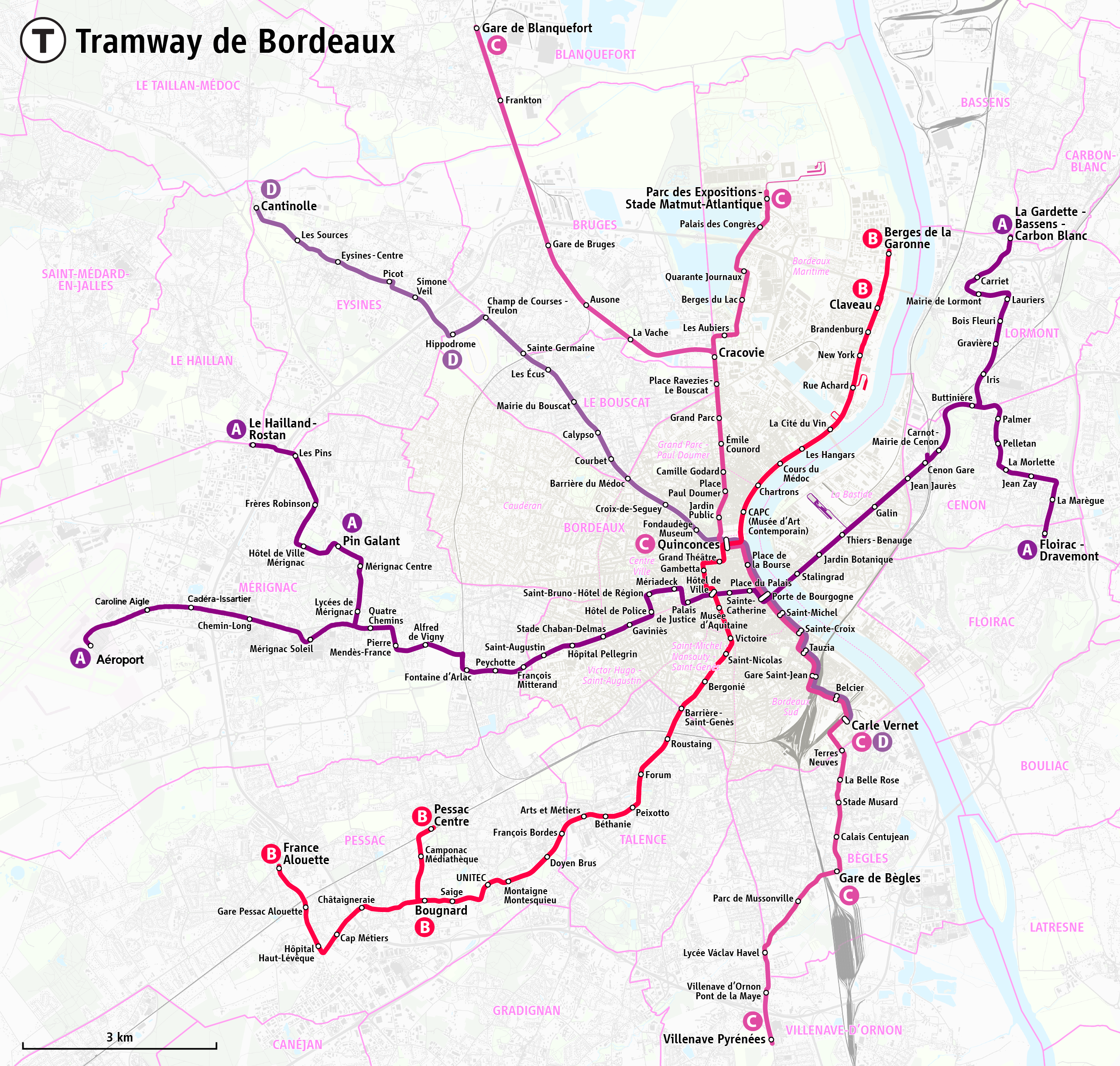
| DescriptionPlan du réseau des tramways de Bordeaux.png |
|
|||
| Date | see file history | |||
| Source | Own work, using OpenStreetMap data for the background | |||
| Author | Maximilian Dörrbecker (Chumwa) | |||
| Permission (Reusing this file) |
All OpenStreetMap data and maps are Creative Commons "CC-BY-SA 2.0" licensed This file is licensed under the Creative Commons Attribution-Share Alike 2.0 Generic license.
|
|||
| Other versions |
|


Captions
Add a one-line explanation of what this file represents
Items portrayed in this file
depicts
image/png
File history
Click on a date/time to view the file as it appeared at that time.
| Date/Time | Thumbnail | Dimensions | User | Comment | |
|---|---|---|---|---|---|
| current | 09:12, 7 January 2024 | | 2,567 × 2,444 (4.68 MB) | Marcel Roblin | Suppression de l'éventuelle extension nord ligne D / Ouverture branche aéroport ligne A / Renommage stations "Aéroport de Bordeaux-Mérignac", "Lindbergh", "Cédera" & "Parc Chemin-Long" sur branche aéroport ligne A |
| 19:33, 21 June 2020 |  | 2,567 × 2,444 (4.37 MB) | Chumwa | corr | |
| 07:14, 13 June 2020 |  | 2,567 × 2,444 (4.37 MB) | Chumwa | corr | |
| 06:52, 13 June 2020 |  | 2,567 × 2,444 (4.37 MB) | Chumwa | update | |
| 19:17, 19 December 2016 |  | 2,469 × 2,444 (4.27 MB) | Chumwa | update | |
| 21:39, 24 August 2016 |  | 2,469 × 2,444 (4.27 MB) | Chumwa | ||
| 20:09, 24 August 2016 |  | 2,469 × 2,444 (4.27 MB) | Chumwa | ||
| 18:41, 24 August 2016 |  | 2,469 × 2,444 (4.3 MB) | Chumwa | {{Information |Description= *{{de|Karte: Netzplan der Straßenbahn Berdeaux}} *{{en|Map of the Bordeaux tramway system}} *{{eo|1=Mapo de la trama retoj de Bordeaux}} *{{fr|Plan du réseau des tramways de Bordeaux}} *{{ro|1=Harta traseelor de tramvai di... |
File usage
The following pages on the English Wikipedia use this file (pages on other projects are not listed):
Global file usage
The following other wikis use this file:
- Usage on de.wikipedia.org
- Usage on de.wikivoyage.org
- Usage on eo.wikipedia.org
- Usage on es.wikipedia.org
- Usage on eu.wikipedia.org
- Usage on fa.wikipedia.org
- Usage on fr.wikipedia.org
- Usage on he.wikivoyage.org
- Usage on hu.wikipedia.org
- Usage on id.wikipedia.org
- Usage on it.wikipedia.org
- Usage on ja.wikipedia.org
- Usage on nl.wikipedia.org
- Usage on oc.wikipedia.org
- Usage on pl.wikipedia.org
- Usage on ru.wikipedia.org
- Usage on sv.wikipedia.org
- Usage on uk.wikipedia.org
- Usage on www.wikidata.org
- Usage on zh.wikipedia.org
Metadata
This file contains additional information, probably added from the digital camera or scanner used to create or digitize it.
If the file has been modified from its original state, some details may not fully reflect the modified file.
| Horizontal resolution | 21.65 dpc |
|---|---|
| Vertical resolution | 21.65 dpc |