File:Physical_map_of_the_Crimea.jpg
From Wikipedia, the free encyclopedia
Original file (3,289 × 2,139 pixels, file size: 2.28 MB, MIME type: image/jpeg)
| This is a file from the Wikimedia Commons. Information from its description page there is shown below. Commons is a freely licensed media file repository. You can help. |
Summary
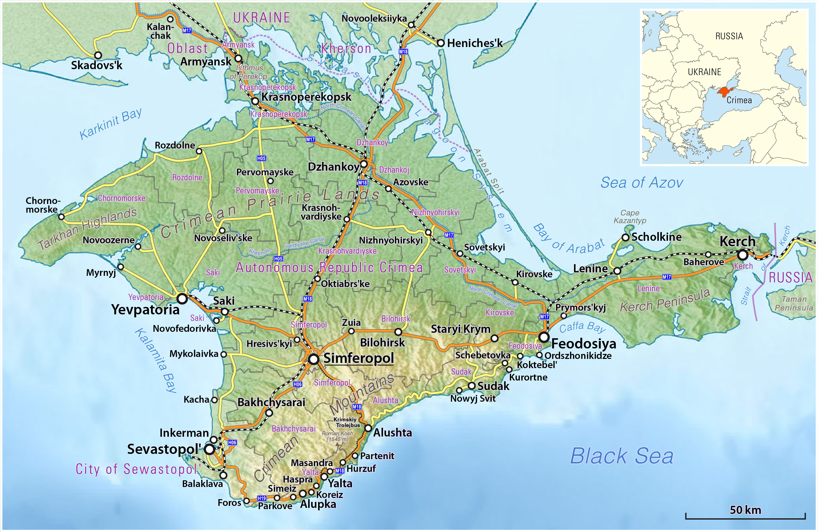
| DescriptionPhysical map of the Crimea.jpg |
Deutsch: Karte der Krim
English: Map of the Crimea |
|||
| Date | see file history | |||
| Source |
Own work, using
|
|||
| Author | Maximilian Dörrbecker (Chumwa) | |||
| Permission (Reusing this file) |
This file is licensed under the Creative Commons Attribution-Share Alike 2.0 Generic license.
Sie dürfen das Bild zu den folgenden Bedingungen nutzen:
|
|||
| Other versions |
|


Captions
Items portrayed in this file
depicts
File history
Click on a date/time to view the file as it appeared at that time.
| Date/Time | Thumbnail | Dimensions | User | Comment | |
|---|---|---|---|---|---|
| current | 06:36, 22 March 2014 | | 3,289 × 2,139 (2.28 MB) | Chumwa | |
| 06:25, 22 March 2014 |  | 3,289 × 2,139 (2.29 MB) | Chumwa | == {{int:filedesc}} == {{Information |Description = {{de|1=Karte der Krim}} {{en|1=Map of the Crimea}} |Source={{own}}, using * OpenStreetMap data * this file by {{U|Виктор В}} for the physical backgroun... |
File usage
Metadata
This file contains additional information, probably added from the digital camera or scanner used to create or digitize it.
If the file has been modified from its original state, some details may not fully reflect the modified file.
| Short title |
|
|---|---|
| Software used | Adobe Illustrator CS5.1 |
| Date and time of digitizing | 08:35, 22 March 2014 |
| File change date and time | 06:35, 22 March 2014 |
| Date metadata was last modified | 08:35, 22 March 2014 |
| Unique ID of original document | uuid:2c693f7d-5cd5-49d9-83f2-830d995a5176 |