File:Pfaelzerwaldkarte_kompakt.png
From Wikipedia, the free encyclopedia
Size of this preview: 464 × 600 pixels. Other resolutions: 186 × 240 pixels | 371 × 480 pixels | 594 × 768 pixels | 792 × 1,024 pixels | 1,899 × 2,454 pixels.
Original file (1,899 × 2,454 pixels, file size: 7.38 MB, MIME type: image/png)
| This is a file from the Wikimedia Commons. Information from its description page there is shown below. Commons is a freely licensed media file repository. You can help. |
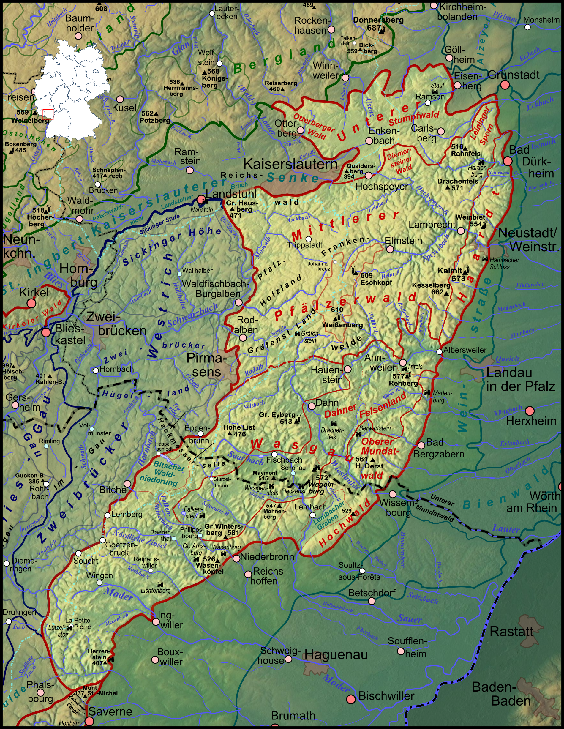
Summary
| DescriptionPfaelzerwaldkarte kompakt.png |
Deutsch: Karte des Pfälzerwaldes auf Basis der naturräumlichen Gliederung nach Pemöller et al und der Gliederung nach Geiger et al, siehe naturräumlich orientierte Hauptkarte |
| Date | |
| Source |
Own work
|
| Author | Elop, based on work by Lencer |
| Other versions |
|
Licensing

|
Permission is granted to copy, distribute and/or modify this document under the terms of the GNU Free Documentation License, Version 1.2 or any later version published by the Free Software Foundation; with no Invariant Sections, no Front-Cover Texts, and no Back-Cover Texts. A copy of the license is included in the section entitled GNU Free Documentation License.http://www.gnu.org/copyleft/fdl.htmlGFDLGNU Free Documentation Licensetruetrue |
Captions
Add a one-line explanation of what this file represents
Items portrayed in this file
depicts
8 February 2012
File history
Click on a date/time to view the file as it appeared at that time.
| Date/Time | Thumbnail | Dimensions | User | Comment | |
|---|---|---|---|---|---|
| current | 21:22, 8 February 2012 | | 1,899 × 2,454 (7.38 MB) | Elop | komplettes Update |
| 01:32, 17 December 2011 |  | 817 × 1,139 (1.55 MB) | Elop | k | |
| 23:45, 16 December 2011 |  | 817 × 1,139 (1.55 MB) | Elop | k | |
| 23:39, 16 December 2011 |  | 817 × 1,139 (1.55 MB) | Elop | k | |
| 21:11, 16 December 2011 |  | 817 × 1,139 (1.55 MB) | Elop | Update | |
| 02:30, 12 December 2011 |  | 817 × 1,139 (1.55 MB) | Elop | insbesondere Ortsstruktur | |
| 18:22, 8 December 2011 |  | 817 × 1,139 (1.55 MB) | Elop | update | |
| 18:50, 30 November 2011 |  | 817 × 1,128 (1.52 MB) | Elop | Flüsse im Süden | |
| 19:08, 29 November 2011 |  | 817 × 1,128 (1.5 MB) | Elop | == Summary == {{Information |Description ={{de|1=Karte des Pfälzerwaldes auf Basis der naturräumlichen Gliederung nach Pemöller und der Gliederung nach Geiger, siehe naturräumlich orientierte Karte}} |
File usage
The following pages on the English Wikipedia use this file (pages on other projects are not listed):
Global file usage
The following other wikis use this file:
- Usage on ar.wikipedia.org
- Usage on arz.wikipedia.org
- Usage on bg.wikipedia.org
- Usage on ca.wikipedia.org
- Usage on ceb.wikipedia.org
- Usage on cs.wikipedia.org
- Usage on de.wikipedia.org
- Pfälzerwald
- Diskussion:Pfälzerwald/Archiv/1
- Benutzer Diskussion:Elop/Archiv 2011
- Gliederung des Pfälzerwaldes
- Wikipedia:Kartenwerkstatt/Archiv/2011-12
- Wikipedia Diskussion:Hauptseite/Artikel des Tages/Archiv/Vorschläge/2012/1
- Diskussion:Pfälzerwald/Archiv/2
- Liste von Bergen im Pfälzerwald
- Diskussion:Peterskopf (Haardt)
- Wikipedia:Hauptseite/Archiv/18. März 2012
- Usage on de.wikivoyage.org
- Usage on fa.wikipedia.org
- Usage on fr.wikipedia.org
- Usage on it.wikivoyage.org
- Usage on nl.wikipedia.org
- Usage on ro.wikipedia.org
- Usage on uk.wikipedia.org
- Usage on www.wikidata.org
- Usage on zh.wikipedia.org
Metadata
This file contains additional information, probably added from the digital camera or scanner used to create or digitize it.
If the file has been modified from its original state, some details may not fully reflect the modified file.
| Horizontal resolution | 118.11 dpc |
|---|---|
| Vertical resolution | 118.11 dpc |
| Software used |
Retrieved from "https://en.wikipedia.org/wiki/File:Pfaelzerwaldkarte_kompakt.png"