File:Pedro_De_Valdivia_Siedlungen_in_Chile_1540_bis_1553.jpg
From Wikipedia, the free encyclopedia
Size of this preview: 187 × 600 pixels. Other resolution: 300 × 962 pixels.
Original file (300 × 962 pixels, file size: 268 KB, MIME type: image/jpeg)
| This is a file from the Wikimedia Commons. Information from its description page there is shown below. Commons is a freely licensed media file repository. You can help. |

|
This historical map image could be re-created using vector graphics as an SVG file. This has several advantages; see Commons:Media for cleanup for more information. If an SVG form of this image is available, please upload it and afterwards replace this template with
{{vector version available|new image name}}.
It is recommended to name the SVG file “Pedro De Valdivia Siedlungen in Chile 1540 bis 1553.svg”—then the template Vector version available (or Vva) does not need the new image name parameter. |
 | This historical map image was uploaded in the JPEG format even though it consists of non-photographic data. This information could be stored more efficiently or accurately in the PNG or SVG format. If possible, please upload a PNG or SVG version of this image without compression artifacts, derived from a non-JPEG source (or with existing artifacts removed). After doing so, please tag the JPEG version with {{Superseded|NewImage.ext}} and remove this tag. This tag should not be applied to photographs or scans. If this image is a diagram or other image suitable for vectorisation, please tag this image with {{Convert to SVG}} instead of {{BadJPEG}}. If not suitable for vectorisation, use {{Convert to PNG}}. For more information, see {{BadJPEG}}. |  |
| DescriptionPedro De Valdivia Siedlungen in Chile 1540 bis 1553.jpg |
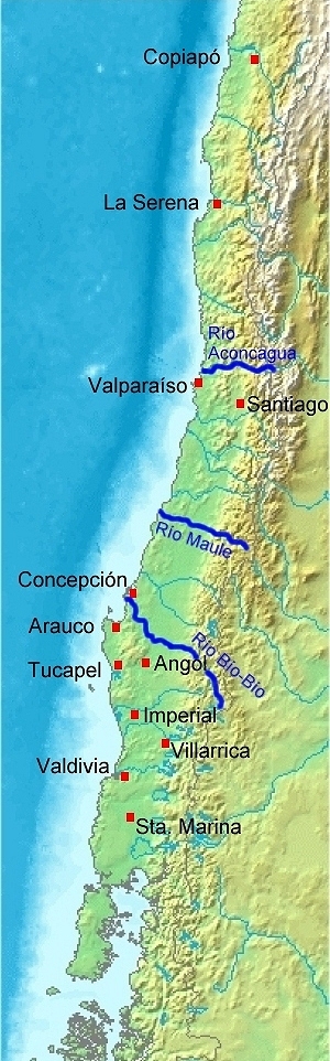
Deutsch: Karte von Chile. Pedro de Valdivia. Koloniale Siedlungen in Chile, 1540 - 1553
English: Map of Chile. Pedro de Valdivia. Locations of colonization in Chile, 1540 - 1553
Español: Mapa de Chile. Pedro de Valdivia. Fundaciones en Chile, 1540 - 1553 |
| Date | (UTC) |
| Source | |
| Author |
|
| Other versions | العربيَّة |
| This is a retouched picture, which means that it has been digitally altered from its original version. Modifications: Orte eingezeichnet/locations added. The original can be viewed here: Map of Chile Demis.png:
|
| Public domainPublic domainfalsefalse |
This image is in the public domain because it came from the site https://www.demis.nl/products/web-map-server/examples/ and was released by the copyright holder. Permission is granted to copy, distribute and/or modify this map since it is based on free of copyright images from: www.demis.nl. See also approval email on de.wp and its clarification.
Deutsch | English | македонски | മലയാളം | Nederlands | slovenščina | +/− |
| Public domainPublic domainfalsefalse |
| This work has been released into the public domain by its copyright holder, www.demis.nl. This applies worldwide. In some countries this may not be legally possible; if so: www.demis.nl grants anyone the right to use this work for any purpose, without any conditions, unless such conditions are required by law. Public domainPublic domainfalsefalse |
Original upload log
This image is a derivative work of the following images:
- Image:Map_of_Chile_Demis.png licensed with PD-Demis
- 2006-12-20T19:50:53Z Mats Halldin 343x1458 (269160 Bytes) Map of [[Chile]] Bounding box West -78°, South -57°, East -66°, North -16°. Center at {{coor d|36.50000|S|72.00000|W|scale:24600000}}. {{demis-pd}} [[category:maps of Chile]]
Uploaded with derivativeFX
Captions
Add a one-line explanation of what this file represents
Items portrayed in this file
depicts
image/jpeg
d8e41a5e0106264531d27f580d45aacadff8fb4a
274,293 byte
962 pixel
300 pixel
File history
Click on a date/time to view the file as it appeared at that time.
| Date/Time | Thumbnail | Dimensions | User | Comment | |
|---|---|---|---|---|---|
| current | 18:23, 20 July 2008 | 300 × 962 (268 KB) | WeHaKa | {{Information |Description= {{de|Karte von Chile. Pedro de Valdivia. Koloniale Siedlungen in Chile, 1540 - 1553}} {{en|Map of Chile. Pedro de Valdivia. Locations of colonization in Chile, 1540 - 1553}} {{es|Mapa de Chile. Pedro de Valdivia. Fu |
File usage
The following pages on the English Wikipedia use this file (pages on other projects are not listed):
Global file usage
The following other wikis use this file:
- Usage on ar.wikipedia.org
- Usage on ca.wikipedia.org
- Usage on de.wikipedia.org
- Usage on es.wikipedia.org
- Usage on fi.wikipedia.org
- Usage on fr.wikipedia.org
- Usage on uk.wikipedia.org
- Usage on www.wikidata.org
Metadata
This file contains additional information, probably added from the digital camera or scanner used to create or digitize it.
If the file has been modified from its original state, some details may not fully reflect the modified file.
| _error | 0 |
|---|