File:Panama_Canal_Map_DE.png
From Wikipedia, the free encyclopedia
Size of this preview: 581 × 600 pixels. Other resolutions: 232 × 240 pixels | 465 × 480 pixels | 744 × 768 pixels | 992 × 1,024 pixels | 2,191 × 2,262 pixels.
Original file (2,191 × 2,262 pixels, file size: 3.5 MB, MIME type: image/png)
| This is a file from the Wikimedia Commons. Information from its description page there is shown below. Commons is a freely licensed media file repository. You can help. |
Summary
| DescriptionPanama Canal Map DE.png |
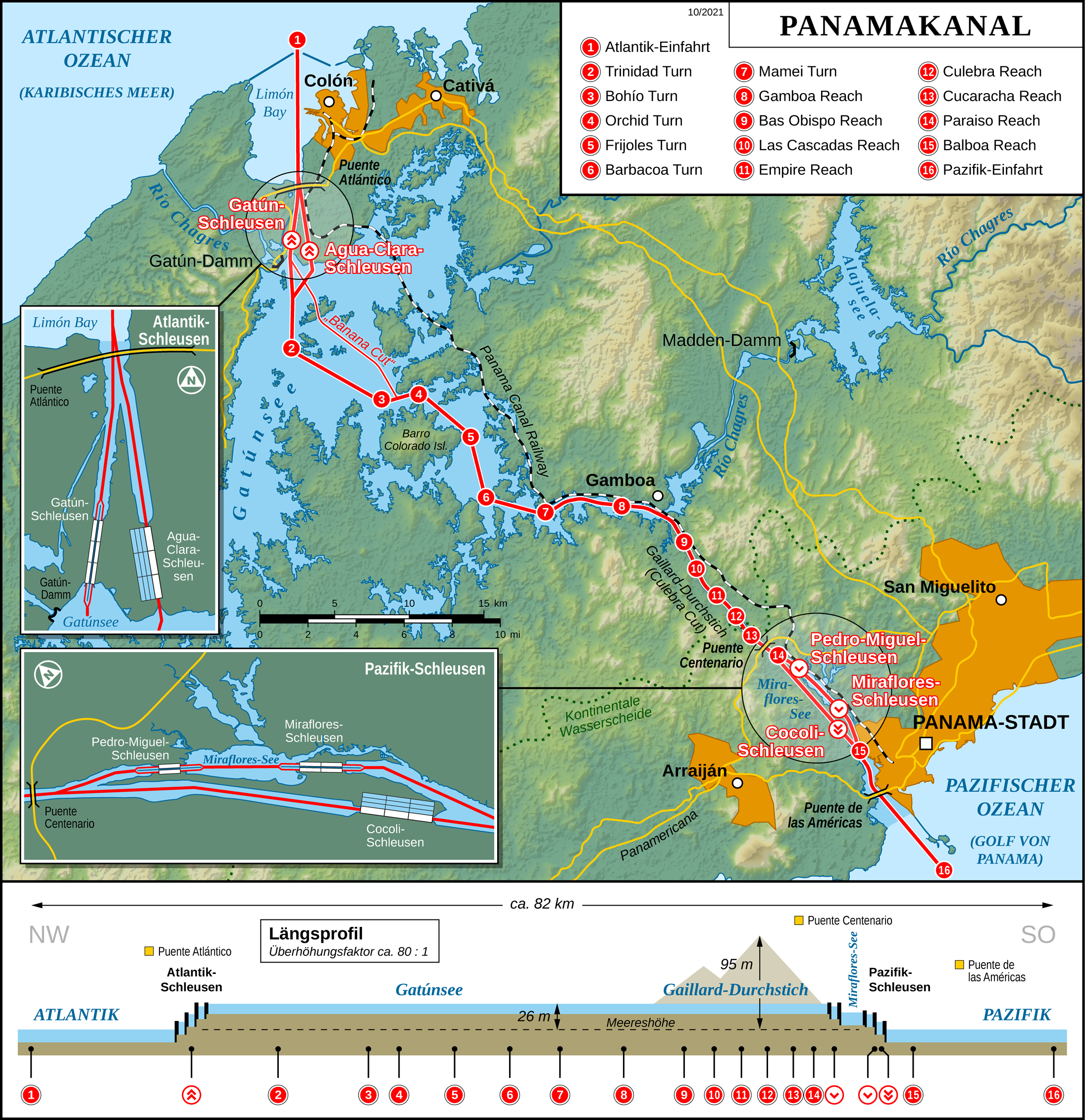
English: Map of the Panama Canal (German version)
Deutsch: Karte des Panamakanals (Deutsche Version) |
| Date | |
| Source |
Own work Map created using: |
| Author | Thoroe |
| Permission (Reusing this file) |
Map data (c) OpenStreetMap (and) contributors, CC-BY-SA |
| Other versions |
[edit]
|


|
This map has been made or improved in the German Kartenwerkstatt (Map Lab). You can propose maps to improve as well.
azərbaycanca ∙ čeština ∙ Deutsch ∙ Deutsch (Sie-Form) ∙ English ∙ español ∙ français ∙ italiano ∙ latviešu ∙ magyar ∙ Nederlands ∙ Plattdüütsch ∙ polski ∙ português ∙ română ∙ sicilianu ∙ slovenščina ∙ suomi ∙ македонски ∙ русский ∙ ქართული ∙ հայերեն ∙ বাংলা ∙ ไทย ∙ +/−
|
Licensing
This file is licensed under the Creative Commons Attribution-Share Alike 2.0 Generic license.
Attribution: Thomas Römer/OpenStreetMap data
- You are free:
- to share – to copy, distribute and transmit the work
- to remix – to adapt the work
- Under the following conditions:
- attribution – You must give appropriate credit, provide a link to the license, and indicate if changes were made. You may do so in any reasonable manner, but not in any way that suggests the licensor endorses you or your use.
- share alike – If you remix, transform, or build upon the material, you must distribute your contributions under the same or compatible license as the original.
Captions
Add a one-line explanation of what this file represents
Items portrayed in this file
depicts
30 May 2012
File history
Click on a date/time to view the file as it appeared at that time.
| Date/Time | Thumbnail | Dimensions | User | Comment | |
|---|---|---|---|---|---|
| current | 15:50, 3 October 2021 | | 2,191 × 2,262 (3.5 MB) | Thoroe | + Puente Atlántico |
| 23:04, 15 February 2017 |  | 2,191 × 2,262 (3.62 MB) | Thoroe | Update | |
| 22:36, 30 March 2014 |  | 1,294 × 1,336 (1.67 MB) | Kopiersperre | optipng | |
| 11:21, 1 June 2012 |  | 1,294 × 1,336 (1.85 MB) | Thoroe | Minor fixes and improvements | |
| 13:25, 30 May 2012 |  | 1,294 × 1,336 (1.85 MB) | Thoroe | {{Information |Description ={{en|1=Map of the Panama Canal (German version)}} {{de|1=Karte des Panamakanals (Deutsche Version)}} |Source ={{own}} Map created using: *[http://gmt.soest.hawaii.edu Gene... |
File usage
No pages on the English Wikipedia use this file (pages on other projects are not listed).
Global file usage
The following other wikis use this file:
- Usage on als.wikipedia.org
- Usage on de.wikipedia.org
- Panamakanal
- Wikipedia:Hauptseite/Jahrestage/November
- Wikipedia:Hauptseite/Jahrestage/November/18
- Benutzer:Thoroe
- Wikipedia:Kartenwerkstatt/Archiv/2012-06
- Wikipedia Diskussion:Hauptseite/Artikel des Tages/Archiv/Vorschläge/2014/Q3
- Wikipedia:Kartenwerkstatt/Karte des Tages/Galerie
- Wikipedia:Kartenwerkstatt/Archiv/2016-04
- Wikipedia:Hauptseite/Archiv/18. November 2023
- Usage on de.wikivoyage.org
- Usage on frr.wikipedia.org
- Usage on nds.wikipedia.org
- Usage on stq.wikipedia.org
Retrieved from "https://en.wikipedia.org/wiki/File:Panama_Canal_Map_DE.png"