File:North_and_south_of_the_Pyrenees_(Year_760).jpg
From Wikipedia, the free encyclopedia
No higher resolution available.
North_and_south_of_the_Pyrenees_(Year_760).jpg (549 × 478 pixels, file size: 92 KB, MIME type: image/jpeg)
| This is a file from the Wikimedia Commons. Information from its description page there is shown below. Commons is a freely licensed media file repository. You can help. |
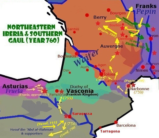
Summary

|
File:North and south of the Pyrenees (Year 760).svg is a vector version of this file. It should be used in place of this JPG file when not inferior.
File:North and south of the Pyrenees (Year 760).jpg → File:North and south of the Pyrenees (Year 760).svg
For more information, see Help:SVG.
|
.svg) |
| DescriptionNorth and south of the Pyrenees (Year 760).jpg |
English: New corrected version upload of previous map |
| Date | |
| Source |
Gimp |
| Author | Iñaki LL |
Licensing
I, the copyright holder of this work, hereby publish it under the following licenses:

|
Permission is granted to copy, distribute and/or modify this document under the terms of the GNU Free Documentation License, Version 1.2 or any later version published by the Free Software Foundation; with no Invariant Sections, no Front-Cover Texts, and no Back-Cover Texts. A copy of the license is included in the section entitled GNU Free Documentation License.http://www.gnu.org/copyleft/fdl.htmlGFDLGNU Free Documentation Licensetruetrue |
This file is licensed under the Creative Commons Attribution-Share Alike 3.0 Unported license.
- You are free:
- to share – to copy, distribute and transmit the work
- to remix – to adapt the work
- Under the following conditions:
- attribution – You must give appropriate credit, provide a link to the license, and indicate if changes were made. You may do so in any reasonable manner, but not in any way that suggests the licensor endorses you or your use.
- share alike – If you remix, transform, or build upon the material, you must distribute your contributions under the same or compatible license as the original.
You may select the license of your choice.
Captions
Add a one-line explanation of what this file represents
Items portrayed in this file
depicts
25 January 2013
image/jpeg
File history
Click on a date/time to view the file as it appeared at that time.
| Date/Time | Thumbnail | Dimensions | User | Comment | |
|---|---|---|---|---|---|
| current | 21:26, 11 June 2013 | | 549 × 478 (92 KB) | Iñaki LLM | Mended flawed previous file |
| 21:21, 11 June 2013 |  | 549 × 478 (92 KB) | Iñaki LLM | Reverted to version as of 06:43, 26 January 2013 | |
| 21:20, 11 June 2013 |  | 549 × 478 (90 KB) | Iñaki LLM | Adjusted borders, added further military campaigns | |
| 06:43, 26 January 2013 |  | 549 × 478 (92 KB) | Iñaki LLM | {{subst:Upload marker added by en.wp UW}} {{Information |Description = {{en|New corrected version upload of previous map}} |Source = Gimp<br/> '''Previously published:''' http://basquemedieval.blogspot.com/ |Date = 2013-01-25 |Author = [[User:Iñaki LL... |
File usage
The following pages on the English Wikipedia use this file (pages on other projects are not listed):
Global file usage
The following other wikis use this file:
- Usage on bn.wikipedia.org
- Usage on es.wikipedia.org
- Usage on eu.wikipedia.org
- Usage on he.wikipedia.org
- Usage on hr.wikipedia.org
- Usage on id.wikipedia.org
- Usage on ja.wikipedia.org
- Usage on ko.wikipedia.org
- Usage on lv.wikipedia.org
- Usage on nl.wikipedia.org
- Usage on sh.wikipedia.org
- Usage on uz.wikipedia.org
- Usage on zh.wikipedia.org
Metadata
This file contains additional information, probably added from the digital camera or scanner used to create or digitize it.
If the file has been modified from its original state, some details may not fully reflect the modified file.
| Author | Inaki |
|---|---|
| Date and time of data generation | 21:33, 9 November 2012 |
| Date and time of digitizing | 21:33, 9 November 2012 |
| DateTimeOriginal subseconds | 52 |
| DateTimeDigitized subseconds | 52 |
.jpg)