File:Navy_Island_map.png
From Wikipedia, the free encyclopedia
No higher resolution available.
Navy_Island_map.png (478 × 600 pixels, file size: 174 KB, MIME type: image/png)
| This is a file from the Wikimedia Commons. Information from its description page there is shown below. Commons is a freely licensed media file repository. You can help. |
Summary
| DescriptionNavy Island map.png |
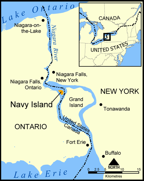
A map showing the location of Navy Island in the Niagara River. The nearby Grand Island is also shown, as are the towns of Niagara Falls, Niagara-on-the-Lake, Tonawanda, Buffalo, and Fort Erie. Created by NormanEinstein, May 11, 2005. |
| Date | 11 May 2005 (original upload date) |
| Source | No machine-readable source provided. Own work assumed (based on copyright claims). |
| Author | No machine-readable author provided. NormanEinstein assumed (based on copyright claims). |
Licensing
I, the copyright holder of this work, hereby publish it under the following licenses:

|
Permission is granted to copy, distribute and/or modify this document under the terms of the GNU Free Documentation License, Version 1.2 or any later version published by the Free Software Foundation; with no Invariant Sections, no Front-Cover Texts, and no Back-Cover Texts. A copy of the license is included in the section entitled GNU Free Documentation License.http://www.gnu.org/copyleft/fdl.htmlGFDLGNU Free Documentation Licensetruetrue |
| This file is licensed under the Creative Commons Attribution-Share Alike 3.0 Unported license. | ||
| ||
| This licensing tag was added to this file as part of the GFDL licensing update.http://creativecommons.org/licenses/by-sa/3.0/CC BY-SA 3.0Creative Commons Attribution-Share Alike 3.0truetrue |
You may select the license of your choice.
Captions
Add a one-line explanation of what this file represents
Items portrayed in this file
depicts
File history
Click on a date/time to view the file as it appeared at that time.
| Date/Time | Thumbnail | Dimensions | User | Comment | |
|---|---|---|---|---|---|
| current | 14:32, 19 May 2005 | | 478 × 600 (174 KB) | NormanEinstein | |
| 20:05, 11 May 2005 |  | 683 × 740 (116 KB) | NormanEinstein | A map showing the location of Navy Island in the Niagara River. The nearby Grand Island is also shown, as are the towns of Niagara Falls, Niagara-on-the-Lake, Tonawanda, Buffalo, and Fort Erie. Created by NormanEinstein. {{PD-self}} |
File usage
The following pages on the English Wikipedia use this file (pages on other projects are not listed):
Global file usage
The following other wikis use this file:
- Usage on ar.wikipedia.org
- Usage on be.wikipedia.org
- Usage on bn.wikipedia.org
- Usage on cv.wikipedia.org
- Usage on de.wikipedia.org
- Usage on es.wikipedia.org
- Usage on fr.wikipedia.org
- Usage on hyw.wikipedia.org
- Usage on it.wikipedia.org
- Usage on ja.wikipedia.org
- Usage on sh.wikipedia.org
- Usage on sv.wikipedia.org
- Usage on sw.wikipedia.org
- Usage on tr.wikipedia.org
- Usage on uk.wikipedia.org
- Usage on zh.wikipedia.org
Retrieved from "https://en.wikipedia.org/wiki/File:Navy_Island_map.png"