File:Mweru_Wantipa_from_space.jpg
From Wikipedia, the free encyclopedia
No higher resolution available.
Mweru_Wantipa_from_space.jpg (325 × 198 pixels, file size: 15 KB, MIME type: image/jpeg)
| This is a file from the Wikimedia Commons. Information from its description page there is shown below. Commons is a freely licensed media file repository. You can help. |
Summary
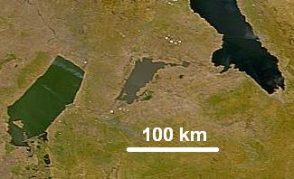
| DescriptionMweru Wantipa from space.jpg | Lake Mweru Wantipa (Mweru Marshes) in northern Zambia photographed from space. Mweru Wantipa is a shallow muddy lake shown in the centre between the greenish Lake Mweru and the dark blue Lake Tanganyika. |
| Date | 26 March 2007 (Original 2000-07-23) |
| Source | cropped from: NASA Visible Earth website |
| Author | NASA, Credit SeaWiFS Project, NASA/Goddard Space Flight Center, and ORBIMAGE |
| Permission (Reusing this file) |
Public domain |
Licensing
| Public domainPublic domainfalsefalse |
| This image is from the Sea-viewing Wide Field-of-view Sensor (SeaWiFS) Project and more than 5 years old.
Satellite data captured by the SeaWIFS sensor are released into the public domain 5 years after capture. Data less than five years old can be re-used only for educational or scientific purposes; any commercial use of such images must be coordinated with GeoEye. [1] |
| Public domainPublic domainfalsefalse |
| This work has been released into the public domain by its copyright holder, GeoEye. This applies worldwide. In some countries this may not be legally possible; if so: GeoEye grants anyone the right to use this work for any purpose, without any conditions, unless such conditions are required by law. Public domainPublic domainfalsefalse |
Captions
Add a one-line explanation of what this file represents
Items portrayed in this file
depicts
image/jpeg
File history
Click on a date/time to view the file as it appeared at that time.
| Date/Time | Thumbnail | Dimensions | User | Comment | |
|---|---|---|---|---|---|
| current | 05:56, 27 March 2007 | | 325 × 198 (15 KB) | Rexparry sydney~commonswiki | {{Information |Description=Lake Mweru Wantipa (Mweru Marshes) in northern Zambia photographed from space. Mweru Wantipa is a shallow muddy lake shown in the centre between the greenish Lake Mweru and the dark blue Lake Tanganyika. |Source=[htt |
File usage
The following pages on the English Wikipedia use this file (pages on other projects are not listed):
Global file usage
The following other wikis use this file:
- Usage on arz.wikipedia.org
- Usage on be.wikipedia.org
- Usage on bh.wikipedia.org
- Usage on ca.wikipedia.org
- Usage on de.wikipedia.org
- Usage on es.wikipedia.org
- Usage on fi.wikipedia.org
- Usage on fr.wikipedia.org
- Usage on he.wikipedia.org
- Usage on it.wikipedia.org
- Usage on ka.wikipedia.org
- Usage on lt.wikipedia.org
- Usage on lv.wikipedia.org
- Usage on my.wikipedia.org
- Usage on nl.wikipedia.org
- Usage on pl.wikipedia.org
- Usage on ru.wikipedia.org
- Usage on te.wikipedia.org
- Usage on uk.wikipedia.org
- Usage on www.wikidata.org
- Usage on zh.wikipedia.org
Metadata
This file contains additional information, probably added from the digital camera or scanner used to create or digitize it.
If the file has been modified from its original state, some details may not fully reflect the modified file.
| _error | 0 |
|---|
Retrieved from "https://en.wikipedia.org/wiki/File:Mweru_Wantipa_from_space.jpg"