File:Montacute_House_East_Front_-_geograph.org.uk_-_851610.jpg
From Wikipedia, the free encyclopedia
No higher resolution available.
Montacute_House_East_Front_-_geograph.org.uk_-_851610.jpg (587 × 411 pixels, file size: 336 KB, MIME type: image/jpeg)
| This is a file from the Wikimedia Commons. Information from its description page there is shown below. Commons is a freely licensed media file repository. You can help. |
Summary
| DescriptionMontacute House East Front - geograph.org.uk - 851610.jpg |
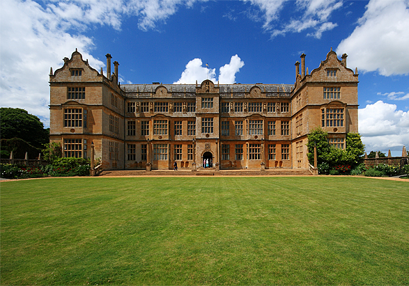
English: Montacute House East Front It was about the time of the Spanish Armada in 1588 that Sir Edward Phelips, a successful lawyer and Speaker of the House of Commons, commissioned the building of Montacute House. It was probably local builder William Arnold who was given the task of creating Sir Edward's new home in the Somerset countryside. Arnold used local Ham Hill stone to create a symmetrical 'H' plan building owing much to the classical detail of the Renaissance style of architecture. There is a carved date of 1601 over the east doorway, probably denoting the year the house was completed.
The Phelips family reigned supreme at Montacute for over three centuries, until the agricultural depression of the late C19 saw the last Phelips leave in 1911, and most of the house contents sold. The house was acquired by the National Trust in 1931. Montacute House is Grade I Listed. |
| Date | |
| Source | From geograph.org.uk |
| Author | Mike Searle |
| Attribution (required by the license) InfoField | Mike Searle / Montacute House East Front / |
InfoField | Mike Searle / Montacute House East Front |
| Camera location | 50° 57′ 04″ N, 2° 42′ 50″ W | View this and other nearby images on: OpenStreetMap |
|---|
| Object location | 50° 57′ 04.3″ N, 2° 42′ 52″ W | View this and other nearby images on: OpenStreetMap |
|---|
Licensing

|
This image was taken from the Geograph project collection. See this photograph's page on the Geograph website for the photographer's contact details. The copyright on this image is owned by Mike Searle and is licensed for reuse under the Creative Commons Attribution-ShareAlike 2.0 license.
|
This file is licensed under the Creative Commons Attribution-Share Alike 2.0 Generic license.
Attribution: Mike Searle
- You are free:
- to share – to copy, distribute and transmit the work
- to remix – to adapt the work
- Under the following conditions:
- attribution – You must give appropriate credit, provide a link to the license, and indicate if changes were made. You may do so in any reasonable manner, but not in any way that suggests the licensor endorses you or your use.
- share alike – If you remix, transform, or build upon the material, you must distribute your contributions under the same or compatible license as the original.
Captions
Add a one-line explanation of what this file represents
Items portrayed in this file
depicts
some value
19 June 2008
50°57'4.0"N, 2°42'49.7"W
50°57'4.28"N, 2°42'52.20"W
File history
Click on a date/time to view the file as it appeared at that time.
| Date/Time | Thumbnail | Dimensions | User | Comment | |
|---|---|---|---|---|---|
| current | 02:48, 21 February 2011 | | 587 × 411 (336 KB) | GeographBot | == {{int:filedesc}} == {{Information |description={{en|1=Montacute House East Front It was about the time of the Spanish Armada in 1588 that Sir Edward Phelips, a successful lawyer and Speaker of the House of Commons, commissioned the building of Montacut |
File usage
The following pages on the English Wikipedia use this file (pages on other projects are not listed):
Global file usage
The following other wikis use this file:
- Usage on de.wikipedia.org
- Usage on es.wikipedia.org
- Usage on fr.wikipedia.org
- Usage on it.wikipedia.org
- Usage on www.wikidata.org
- Usage on zh.wikipedia.org
Metadata
This file contains additional information, probably added from the digital camera or scanner used to create or digitize it.
If the file has been modified from its original state, some details may not fully reflect the modified file.
| _error | 0 |
|---|