File:Modern_Swabia-map.PNG
From Wikipedia, the free encyclopedia
Size of this preview: 439 × 599 pixels. Other resolutions: 176 × 240 pixels | 352 × 480 pixels | 563 × 768 pixels | 750 × 1,024 pixels | 1,351 × 1,844 pixels.
Original file (1,351 × 1,844 pixels, file size: 496 KB, MIME type: image/png)
| This is a file from the Wikimedia Commons. Information from its description page there is shown below. Commons is a freely licensed media file repository. You can help. |
Summary
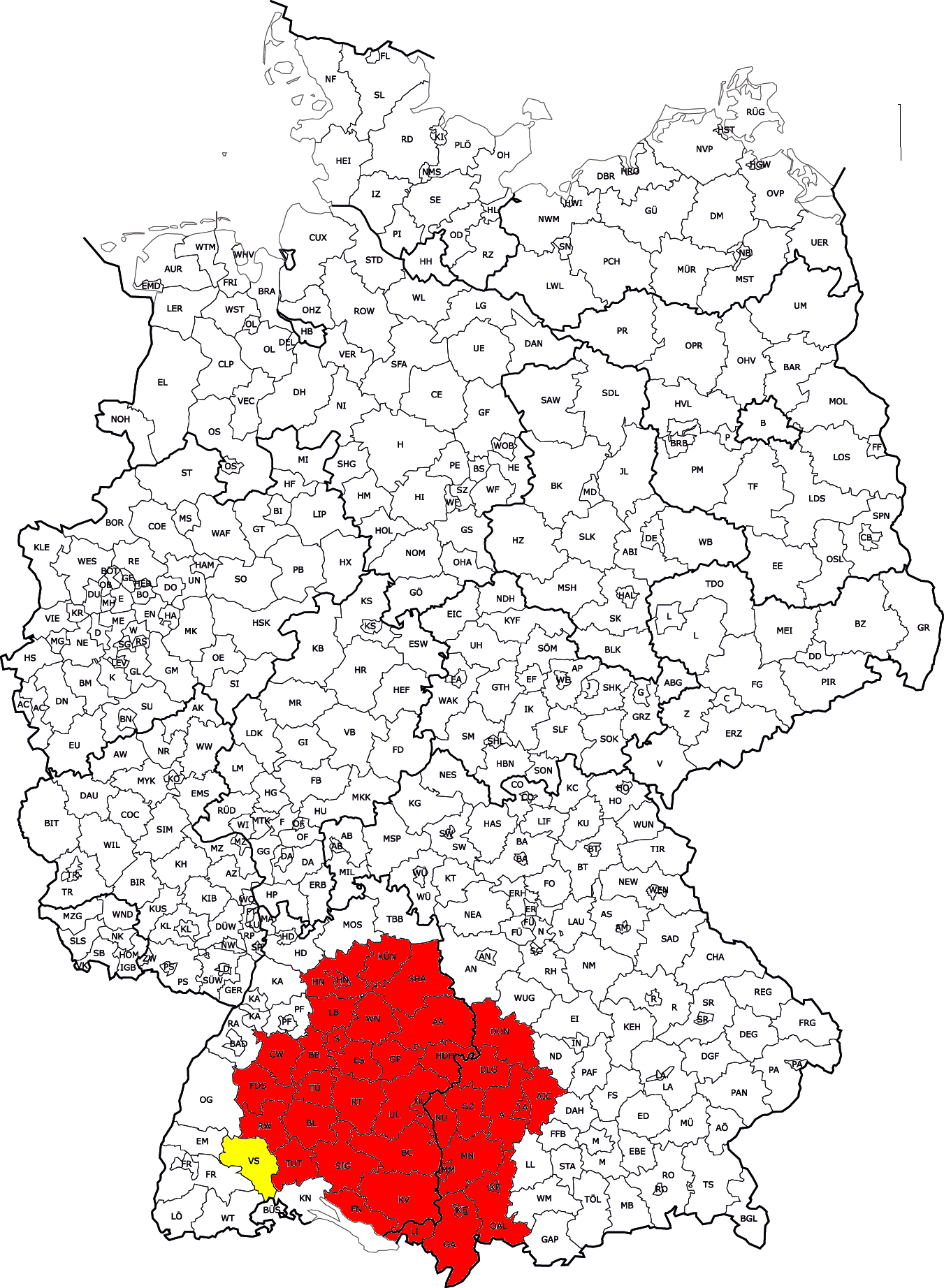
| DescriptionModern Swabia-map.PNG |
This file was uploaded with Commonist. Hrvatski: Karta suvremene Švapske unutar Njemačke English: Map of modern Swabia inside of Germany |
| Date | (UTC) |
| Source | |
| Author |
|
Licensing
This file is licensed under the Creative Commons Attribution-Share Alike 3.0 Unported license.
- You are free:
- to share – to copy, distribute and transmit the work
- to remix – to adapt the work
- Under the following conditions:
- attribution – You must give appropriate credit, provide a link to the license, and indicate if changes were made. You may do so in any reasonable manner, but not in any way that suggests the licensor endorses you or your use.
- share alike – If you remix, transform, or build upon the material, you must distribute your contributions under the same or compatible license as the original.
Captions
Add a one-line explanation of what this file represents
Items portrayed in this file
depicts
File history
Click on a date/time to view the file as it appeared at that time.
| Date/Time | Thumbnail | Dimensions | User | Comment | |
|---|---|---|---|---|---|
| current | 06:51, 19 February 2013 | | 1,351 × 1,844 (496 KB) | Quahadi | |
| 17:21, 18 February 2013 |  | 1,351 × 1,844 (496 KB) | R-41~commonswiki | Adding historical territories held by the Duchy of Swabia, particularly in Baden. | |
| 10:52, 3 October 2011 |  | 1,351 × 1,844 (496 KB) | Quahadi | {{Information |Description={{hr|Karta Švapske unutar Njemačke}}{{en|Map of Swabia inside of Germany}} |Source=*Kfz-Kennzeichen_Deutschlands.png *KgrWuerttemberg.png *[[:File:Bayer | |
| 16:15, 22 August 2011 |  | 1,351 × 1,844 (496 KB) | Quahadi | {{Information |Description={{hr|Karta Švapske unutar Njemačke}}{{en|Map of Swabia inside of Germany}} |Source=*Kfz-Kennzeichen_Deutschlands.png *KgrWuerttemberg.png *[[:File:Bayer | |
| 12:50, 18 July 2011 |  | 1,351 × 1,844 (496 KB) | Quahadi | Reverted to version as of 10:54, 17 July 2011 | |
| 12:50, 18 July 2011 |  | 1,351 × 1,844 (496 KB) | Quahadi | {{Information |Description={{hr|Karta Švapske unutar Njemačke}}{{en|Map of Swabia inside of Germany}} |Source=*Kfz-Kennzeichen_Deutschlands.png *KgrWuerttemberg.png *[[:File:Bayer | |
| 10:59, 17 July 2011 |  | 1,351 × 1,844 (496 KB) | Quahadi | {{Information |Description={{hr|Karta Švapske unutar Njemačke}}{{en|Map of Swabia inside of Germany}} |Source=*Kfz-Kennzeichen_Deutschlands.png *KgrWuerttemberg.png *[[:File:Bayer | |
| 10:54, 17 July 2011 |  | 1,351 × 1,844 (496 KB) | Quahadi | {{Information |Description={{hr|Karta Švapske unutar Njemačke}}{{en|Map of Swabia inside of Germany}} |Source=*Kfz-Kennzeichen_Deutschlands.png *KgrWuerttemberg.png *[[:File:Bayer | |
| 09:25, 15 July 2011 |  | 1,351 × 1,844 (496 KB) | Quahadi | {{Information |Description={{hr|Karta Švapske}}{{en|Map of Swabia}} |Source=*Kfz-Kennzeichen_Deutschlands.png *KgrWuerttemberg.png *[[:File:Bayern_rbschwaben.png|Bayern_rbschwaben. | |
| 21:06, 14 July 2011 |  | 1,351 × 1,844 (496 KB) | Quahadi | {{Information |Description={{hr|Karta Švapske}}{{en|Map of Swabia}} |Source=*File:Kfz-Kennzeichen_Deutschlands.png *File:KgrWuerttemberg.png *File:Bayern_rbschwaben.png : |Date=2011-07-14 20:57 (UTC) |Author=*[[:File:Kfz-Kennzeichen_D |
File usage
The following pages on the English Wikipedia use this file (pages on other projects are not listed):
Global file usage
The following other wikis use this file:
- Usage on als.wikipedia.org
- Usage on ang.wikipedia.org
- Usage on an.wikipedia.org
- Usage on arz.wikipedia.org
- Usage on be-tarask.wikipedia.org
- Usage on bg.wikipedia.org
- Usage on cs.wikipedia.org
- Usage on cy.wikipedia.org
- Usage on el.wikipedia.org
- Usage on es.wikipedia.org
- Usage on fa.wikipedia.org
- Usage on fy.wikipedia.org
- Usage on ga.wikipedia.org
- Usage on hi.wikipedia.org
- Usage on hr.wikipedia.org
- Usage on hu.wikipedia.org
- Usage on it.wikipedia.org
- Usage on ja.wikipedia.org
- Usage on ka.wikipedia.org
- Usage on ko.wikipedia.org
- Usage on mk.wikipedia.org
- Usage on pl.wikipedia.org
- Usage on pl.wiktionary.org
- Usage on pt.wikipedia.org
- Usage on sh.wikipedia.org
- Usage on sr.wikipedia.org
- Usage on sv.wikipedia.org
- Usage on ta.wikipedia.org
- Usage on zh-min-nan.wikipedia.org
- Usage on zh.wikipedia.org
Retrieved from "https://en.wikipedia.org/wiki/File:Modern_Swabia-map.PNG"