File:MidasSehri.Tomb.jpg
From Wikipedia, the free encyclopedia
Size of this preview: 800 × 553 pixels. Other resolutions: 320 × 221 pixels | 640 × 442 pixels | 1,024 × 708 pixels | 1,280 × 885 pixels | 2,023 × 1,398 pixels.
Original file (2,023 × 1,398 pixels, file size: 272 KB, MIME type: image/jpeg)
| This is a file from the Wikimedia Commons. Information from its description page there is shown below. Commons is a freely licensed media file repository. You can help. |
Summary
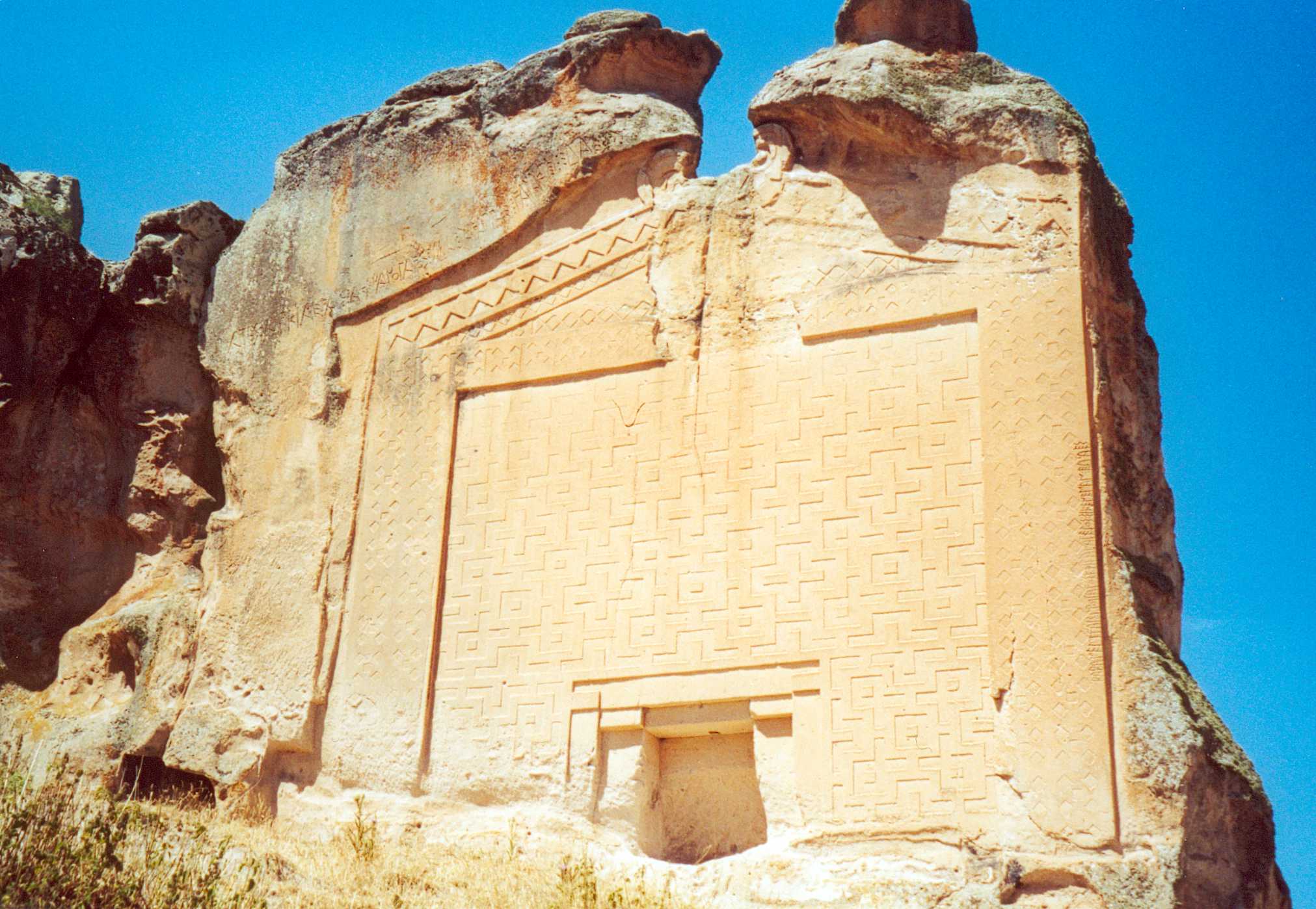
| DescriptionMidasSehri.Tomb.jpg | Midas Tomb at the archeological site Midas City (Midas Şehri). The site is in the village of Yazilikaya, midway between Eskişehir and Afyon. See also a close-up of the inscription. The relief is 17 meters high and dates from the 6th century BC. |
| Date | |
| Source | Own work |
| Author | User:China_Crisis |
| Permission (Reusing this file) |
[1] |
| Camera location | 39° 12′ 18″ N, 30° 42′ 54″ E | View this and other nearby images on: OpenStreetMap |
|---|
Licensing
I, the copyright holder of this work, hereby publish it under the following license:
This file is licensed under the Creative Commons Attribution-Share Alike 2.5 Generic license.
- You are free:
- to share – to copy, distribute and transmit the work
- to remix – to adapt the work
- Under the following conditions:
- attribution – You must give appropriate credit, provide a link to the license, and indicate if changes were made. You may do so in any reasonable manner, but not in any way that suggests the licensor endorses you or your use.
- share alike – If you remix, transform, or build upon the material, you must distribute your contributions under the same or compatible license as the original.
Captions
Add a one-line explanation of what this file represents
Midas Anıtı
Items portrayed in this file
depicts
39°12'18.000"N, 30°42'54.000"E
6 July 2001
image/jpeg
File history
Click on a date/time to view the file as it appeared at that time.
| Date/Time | Thumbnail | Dimensions | User | Comment | |
|---|---|---|---|---|---|
| current | 14:36, 31 May 2006 | | 2,023 × 1,398 (272 KB) | China Crisis |
File usage
The following pages on the English Wikipedia use this file (pages on other projects are not listed):
- Eskişehir Province
- Han, Eskişehir
- Midas
- Phrygia
- Phrygian Way
- Phrygians
- Rock-cut architecture
- Rock-cut tomb
- Tentative list of World Heritage Sites in Turkey
- Yazılı, Han
- Talk:Rock-cut architecture
- User:SomeGuyWhoRandomlyEdits/List of Greek mythological rulers (by tribe)
- User:SomeGuyWhoRandomlyEdits/List of rulers in the Mediterranean sea region during antiquity
- User:SomeGuyWhoRandomlyEdits/List of rulers of Turkey
Global file usage
The following other wikis use this file:
- Usage on af.wikipedia.org
- Usage on ar.wikipedia.org
- Usage on az.wikipedia.org
- Usage on be-tarask.wikipedia.org
- Usage on be.wikipedia.org
- Usage on ca.wikipedia.org
- Usage on ce.wikipedia.org
- Usage on crh.wikipedia.org
- Usage on de.wikipedia.org
- Usage on diq.wikipedia.org
- Usage on dsb.wikipedia.org
- Usage on es.wikipedia.org
- Usage on fa.wikipedia.org
- Usage on fr.wikipedia.org
- Usage on hy.wikipedia.org
- Usage on it.wikipedia.org
- Usage on ja.wikipedia.org
- Usage on ka.wikipedia.org
- Usage on mk.wikipedia.org
- Usage on nl.wikipedia.org
- Usage on nn.wikipedia.org
- Usage on no.wikipedia.org
- Usage on pl.wikipedia.org
- Usage on ru.wikipedia.org
- Usage on sco.wikipedia.org
- Usage on sk.wikipedia.org
- Usage on sl.wikipedia.org
- Usage on ta.wikipedia.org
- Usage on tr.wikipedia.org
- Usage on tr.wikivoyage.org
- Usage on tt.wikipedia.org
View more global usage of this file.
Metadata
This file contains additional information, probably added from the digital camera or scanner used to create or digitize it.
If the file has been modified from its original state, some details may not fully reflect the modified file.
| Contact information | <picasastamp/> |
|---|
Retrieved from "https://en.wikipedia.org/wiki/File:MidasSehri.Tomb.jpg"