File:Map_of_the_annual_average_discharge_of_Rhine_and_Maas_2000-2011_(EN).png
From Wikipedia, the free encyclopedia
Size of this preview: 737 × 600 pixels. Other resolutions: 295 × 240 pixels | 590 × 480 pixels | 944 × 768 pixels | 1,259 × 1,024 pixels | 2,518 × 2,048 pixels | 2,585 × 2,103 pixels.
Original file (2,585 × 2,103 pixels, file size: 348 KB, MIME type: image/png)
| This is a file from the Wikimedia Commons. Information from its description page there is shown below. Commons is a freely licensed media file repository. You can help. |
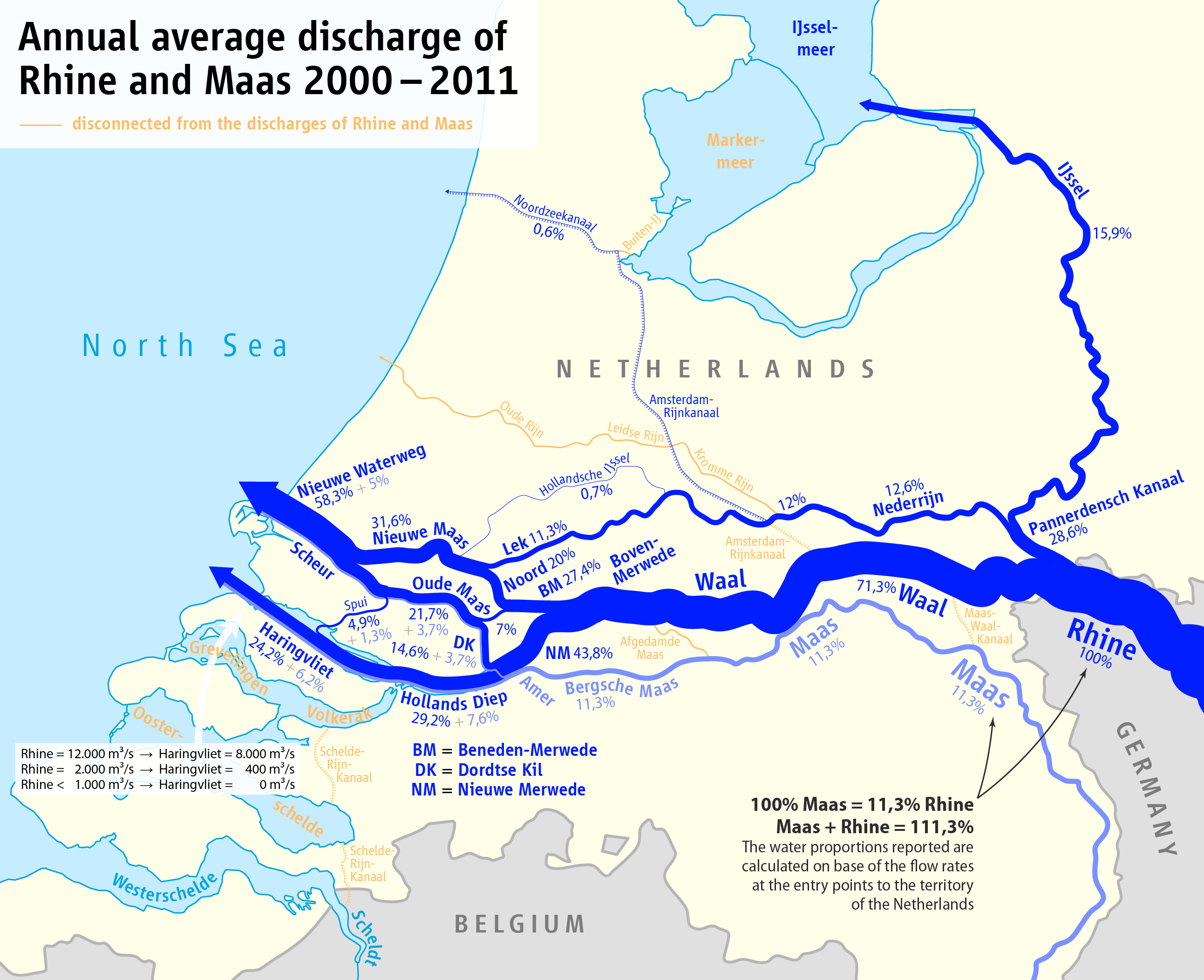
| DescriptionMap of the annual average discharge of Rhine and Maas 2000-2011 (EN).png |
|
| Date | see file history |
| Source |
Own work, using
|
| Author | Maximilian Dörrbecker (Chumwa) |
| Permission (Reusing this file) |
I, the copyright holder of this work, hereby publish it under the following license: This file is licensed under the Creative Commons Attribution-Share Alike 2.5 Generic license.
Sie dürfen das Bild zu den folgenden Bedingungen nutzen:
|
| Other versions |
|
.png)
.png)
.png)
.png)


|
This map image could be re-created using vector graphics as an SVG file. This has several advantages; see Commons:Media for cleanup for more information. If an SVG form of this image is available, please upload it and afterwards replace this template with
{{vector version available|new image name}}.
It is recommended to name the SVG file “Map of the annual average discharge of Rhine and Maas 2000-2011 (EN).svg”—then the template Vector version available (or Vva) does not need the new image name parameter. |
Captions
Add a one-line explanation of what this file represents
Items portrayed in this file
depicts
image/png
File history
Click on a date/time to view the file as it appeared at that time.
| Date/Time | Thumbnail | Dimensions | User | Comment | |
|---|---|---|---|---|---|
| current | 23:08, 6 October 2016 | | 2,585 × 2,103 (348 KB) | Cmdrjameson | Compressed with pngout. Reduced by 225kB (39% decrease). |
| 19:42, 5 March 2016 |  | 2,585 × 2,103 (574 KB) | Chumwa | ||
| 19:03, 3 February 2016 |  | 3,589 × 2,919 (840 KB) | Chumwa | ||
| 06:38, 3 February 2016 |  | 3,589 × 2,919 (840 KB) | Chumwa | {{Information |Description= *{{de|Karte der Aufteilung der Abflüsse im Rhein-Maas-Delta 2000-2011}} *{{en|Map of the partition of Rhine and Meuse water among the various branches of their delta 2000-2011}} |Source={{Own}}, using * [[:File:Netherlands... |
File usage
The following pages on the English Wikipedia use this file (pages on other projects are not listed):
Global file usage
The following other wikis use this file:
- Usage on bg.wikipedia.org
- Usage on da.wikipedia.org
- Usage on de.wikipedia.org
- Usage on en.wiktionary.org
- Usage on es.wikipedia.org
- Usage on eu.wikipedia.org
- Usage on fr.wikipedia.org
- Usage on id.wikipedia.org
- Usage on it.wikipedia.org
- Usage on ru.wikipedia.org
- Usage on sl.wikipedia.org
- Usage on sv.wikipedia.org
- Usage on tr.wikipedia.org
- Usage on uk.wikipedia.org
- Usage on vep.wikipedia.org
- Usage on zh.wikipedia.org
Metadata
This file contains additional information, probably added from the digital camera or scanner used to create or digitize it.
If the file has been modified from its original state, some details may not fully reflect the modified file.
| Horizontal resolution | 28.35 dpc |
|---|---|
| Vertical resolution | 28.35 dpc |
| Software used |