File:Map_of_Vedic_India.png
From Wikipedia, the free encyclopedia
No higher resolution available.
Map_of_Vedic_India.png (683 × 489 pixels, file size: 424 KB, MIME type: image/png)
| This is a file from the Wikimedia Commons. Information from its description page there is shown below. Commons is a freely licensed media file repository. You can help. |
Dbachmann, the copyright holder of this work, hereby publishes it under the following license:

|
Permission is granted to copy, distribute and/or modify this document under the terms of the GNU Free Documentation License, Version 1.2 or any later version published by the Free Software Foundation; with no Invariant Sections, no Front-Cover Texts, and no Back-Cover Texts. A copy of the license is included in the section entitled GNU Free Documentation License.http://www.gnu.org/copyleft/fdl.htmlGFDLGNU Free Documentation Licensetruetrue |
| This file is licensed under the Creative Commons Attribution-Share Alike 3.0 Unported license. | ||
| Attribution: Dbachmann | ||
| ||
| This licensing tag was added to this file as part of the GFDL licensing update.http://creativecommons.org/licenses/by-sa/3.0/CC BY-SA 3.0Creative Commons Attribution-Share Alike 3.0truetrue |
derivative works
Derivative works of this file: Map of Vedic India ru.png
Captions
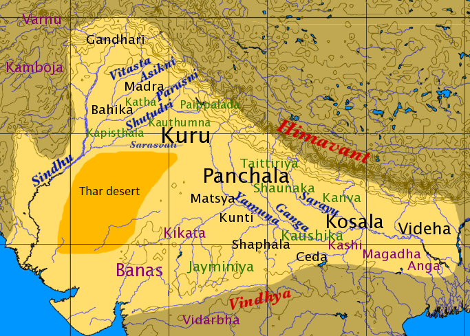
''Āryāvarta'' during the Mahajanapadas era (c. 600-300 BC)
စန္ဒသူရိယ
Items portrayed in this file
depicts
image/png
File history
Click on a date/time to view the file as it appeared at that time.
| Date/Time | Thumbnail | Dimensions | User | Comment | |
|---|---|---|---|---|---|
| current | 13:59, 18 February 2016 | | 683 × 489 (424 KB) | Mywikicommons | Reverted to version as of 13:48, 18 February 2016 (UTC) |
| 13:59, 18 February 2016 |  | 683 × 489 (424 KB) | Mywikicommons | Reupload - Minor addition : Thar Desert (text) added to map according to already given sources. | |
| 13:48, 18 February 2016 |  | 683 × 489 (424 KB) | Mywikicommons | Minor addition : Thar Desert (text) added to map according to already given sources. | |
| 11:04, 22 August 2005 |  | 683 × 489 (353 KB) | Dbachmann | by en:User:Dbachmann {{GFDL}} |
File usage
The following pages on the English Wikipedia use this file (pages on other projects are not listed):
- Bareilly district
- History of Bareilly
- History of Rajasthan
- Kaithal
- Kambu Swayambhuva
- List of ancient Indo-Aryan peoples and tribes
- Sarasvati River
- Tagaung Kingdom
- Thar Desert
- Videha
- Vindhya Range
- User:Amogh gulwady
- User:Bongan/Testing
- User:ImperiumCaelestis
- User:JogiAsad/Archive
- User:JogiAsad/Footer
- User:JogiAsad/Userbox/Sindhu Kingdom
- User:MightyParty/Khera
- User:NittyG/Draft: Indo-Aryan Migrations: Development of theory
Global file usage
The following other wikis use this file:
- Usage on af.wikipedia.org
- Usage on als.wikipedia.org
- Usage on anp.wikipedia.org
- Usage on ar.wikipedia.org
- Usage on ast.wikipedia.org
- Usage on az.wikipedia.org
- Usage on bg.wikipedia.org
- Usage on bh.wikipedia.org
- Usage on bn.wikipedia.org
- Usage on ca.wikipedia.org
- Usage on cs.wikipedia.org
- Usage on de.wikipedia.org
- Usage on el.wikipedia.org
- Usage on en.wikibooks.org
- Usage on eo.wikipedia.org
- Usage on es.wikipedia.org
View more global usage of this file.
Metadata
This file contains additional information, probably added from the digital camera or scanner used to create or digitize it.
If the file has been modified from its original state, some details may not fully reflect the modified file.
| Horizontal resolution | 78.74 dpc |
|---|---|
| Vertical resolution | 78.74 dpc |
| File change date and time | 11:03, 22 August 2005 |
Retrieved from "https://en.wikipedia.org/wiki/File:Map_of_Vedic_India.png"