File:Map_administrative_divisions_of_the_First_French_Empire_1812-zh.svg
From Wikipedia, the free encyclopedia

Size of this PNG preview of this SVG file: 712 × 600 pixels. Other resolutions: 285 × 240 pixels | 570 × 480 pixels | 912 × 768 pixels | 1,216 × 1,024 pixels | 2,432 × 2,048 pixels | 2,052 × 1,728 pixels.
Original file (SVG file, nominally 2,052 × 1,728 pixels, file size: 2.83 MB)
| This is a file from the Wikimedia Commons. Information from its description page there is shown below. Commons is a freely licensed media file repository. You can help. |
Summary
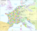
| DescriptionMap administrative divisions of the First French Empire 1812-zh.svg |
中文(中国大陆):法兰西第一帝国行政区划,1812年。
English: Administrative divisions of the First French Empire in 1812. |
| Date | |
| Source | Translation of File:Map_administrative_divisions_of_the_First_French_Empire_1812-fr.svg |
| Author | Andrein, translated by Buernia |
| Other versions |
[edit]
|


Licensing
This file is licensed under the Creative Commons Attribution-Share Alike 4.0 International license.
- You are free:
- to share – to copy, distribute and transmit the work
- to remix – to adapt the work
- Under the following conditions:
- attribution – You must give appropriate credit, provide a link to the license, and indicate if changes were made. You may do so in any reasonable manner, but not in any way that suggests the licensor endorses you or your use.
- share alike – If you remix, transform, or build upon the material, you must distribute your contributions under the same or compatible license as the original.
Captions
Add a one-line explanation of what this file represents
Items portrayed in this file
depicts
21 December 2020
File history
Click on a date/time to view the file as it appeared at that time.
| Date/Time | Thumbnail | Dimensions | User | Comment | |
|---|---|---|---|---|---|
| current | 01:57, 10 October 2023 | | 2,052 × 1,728 (2.83 MB) | Buernia | Change font. |
| 03:29, 21 December 2020 |  | 2,052 × 1,728 (2.83 MB) | Buernia | fix. | |
| 03:18, 21 December 2020 |  | 2,052 × 1,728 (2.83 MB) | Buernia | Uploaded a work by Andrein, translated by Buernia from Translation of File:Map_administrative_divisions_of_the_First_French_Empire_1812-fr.svg with UploadWizard |
File usage
No pages on the English Wikipedia use this file (pages on other projects are not listed).
Global file usage
The following other wikis use this file:
- Usage on zh.wikipedia.org
Metadata
This file contains additional information, probably added from the digital camera or scanner used to create or digitize it.
If the file has been modified from its original state, some details may not fully reflect the modified file.
| Width | 2051.7188 |
|---|---|
| Height | 1727.8906 |