File:Map_administrative_divisions_of_the_First_French_Empire_1812-fr.svg
From Wikipedia, the free encyclopedia

Size of this PNG preview of this SVG file: 712 × 600 pixels. Other resolutions: 285 × 240 pixels | 570 × 480 pixels | 912 × 768 pixels | 1,216 × 1,024 pixels | 2,432 × 2,048 pixels | 2,052 × 1,728 pixels.
Original file (SVG file, nominally 2,052 × 1,728 pixels, file size: 2.84 MB)
| This is a file from the Wikimedia Commons. Information from its description page there is shown below. Commons is a freely licensed media file repository. You can help. |
Summary
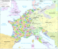
| DescriptionMap administrative divisions of the First French Empire 1812-fr.svg |
Français : Division administrative du Premier Empire Français en 1812 English: Administrative divisions of the First French Empire in 1812 - French version |
| Date | |
| Source |
|
| Author | Andrein |
| Other versions |
[edit]
|


| This SVG file contains embedded text that can be translated into your language, using any capable SVG editor, text editor or the SVG Translate tool. For more information see: About translating SVG files. |
Licensing
I, the copyright holder of this work, hereby publish it under the following license:
This file is licensed under the Creative Commons Attribution-Share Alike 4.0 International license.
- You are free:
- to share – to copy, distribute and transmit the work
- to remix – to adapt the work
- Under the following conditions:
- attribution – You must give appropriate credit, provide a link to the license, and indicate if changes were made. You may do so in any reasonable manner, but not in any way that suggests the licensor endorses you or your use.
- share alike – If you remix, transform, or build upon the material, you must distribute your contributions under the same or compatible license as the original.
Captions
Add a one-line explanation of what this file represents
Éléments décrits dans ce fichier
depicts
Valeur sans élément de Wikidata
19 July 2015
File history
Click on a date/time to view the file as it appeared at that time.
| Date/Time | Thumbnail | Dimensions | User | Comment | |
|---|---|---|---|---|---|
| current | 14:02, 26 August 2015 | | 2,052 × 1,728 (2.84 MB) | Bibi Saint-Pol | Correction de coquilles et typographie |
| 19:41, 20 July 2015 |  | 2,052 × 1,728 (2.82 MB) | ArdadN | spelling, some French city names | |
| 17:11, 20 July 2015 |  | 2,052 × 1,728 (2.82 MB) | ArdadN | 1 | |
| 17:05, 20 July 2015 |  | 2,052 × 1,728 (2.82 MB) | ArdadN | font size | |
| 16:17, 20 July 2015 |  | 2,052 × 1,728 (2.82 MB) | ArdadN | 1 | |
| 13:56, 20 July 2015 |  | 2,052 × 1,728 (2.81 MB) | ArdadN | Carinthie | |
| 13:51, 20 July 2015 |  | 2,052 × 1,728 (2.81 MB) | ArdadN | better fonts | |
| 10:49, 20 July 2015 |  | 2,052 × 1,728 (2.81 MB) | ArdadN | typhos | |
| 23:30, 19 July 2015 |  | 2,052 × 1,728 (2.81 MB) | ArdadN | 1 | |
| 19:51, 19 July 2015 |  | 2,052 × 1,728 (3.61 MB) | ArdadN | one more try.. |
File usage
The following pages on the English Wikipedia use this file (pages on other projects are not listed):
Global file usage
The following other wikis use this file:
- Usage on eo.wikipedia.org
- Usage on fr.wikipedia.org
- Département français
- Premier Empire
- Liste des départements français de 1811
- Pays-Bas (toponymie)
- Chronologie de la France sous le Consulat et le Premier Empire
- Histoire des départements français
- Départements français d'Espagne
- Histoire des Hautes-Alpes
- Utilisateur:Thib Phil/Bac à sable 6
- Wikipédia:Oracle/semaine 17 2012
- Discussion:Départements français d'Espagne
- Rive gauche du Rhin
- Mariage de 6 000 soldats de l'Empire
- Aspects économiques et logistiques des guerres napoléoniennes
- Discussion utilisateur:Flappiefh/Archives/2013-2016
- Discussion:Départements français d'Espagne/LSV 14420
- Wikipédia:Statistiques des anecdotes de la page d'accueil/Visibilité des anecdotes (2018)
- Wikipédia:Statistiques des anecdotes de la page d'accueil/Visibilité des anecdotes (2018)/2018 05
- Projet:Aide et accueil/Twitter/Tweets/archives/mai 2018
- Utilisateur:GhosterBot/BacASable/Aide et accueil/Twitter/Tweets/archives/mai 2018
- Wikipédia:Le saviez-vous ?/Archives/2018
- Départements français d'Allemagne
- Départements français de Suisse
- Utilisateur:DreamcoatJoey/Brouillon/Histoire de l'influence territoriale de la France
- Usage on fr.wiktionary.org
- Usage on la.wikipedia.org
- Usage on ru.wikipedia.org
- Usage on sh.wikipedia.org
- Usage on sv.wikipedia.org
- Usage on vi.wikipedia.org
Metadata
This file contains additional information, probably added from the digital camera or scanner used to create or digitize it.
If the file has been modified from its original state, some details may not fully reflect the modified file.
| Width | 2051.7188 |
|---|---|
| Height | 1727.8906 |