File:Map_administrative_divisions_of_the_First_French_Empire_1812-de.svg
From Wikipedia, the free encyclopedia

Size of this PNG preview of this SVG file: 745 × 600 pixels. Other resolutions: 298 × 240 pixels | 596 × 480 pixels | 954 × 768 pixels | 1,272 × 1,024 pixels | 2,544 × 2,048 pixels | 1,646 × 1,325 pixels.
Original file (SVG file, nominally 1,646 × 1,325 pixels, file size: 6.3 MB)
| This is a file from the Wikimedia Commons. Information from its description page there is shown below. Commons is a freely licensed media file repository. You can help. |
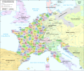
| DescriptionMap administrative divisions of the First French Empire 1812-de.svg |
English: Own work. |
| Date | (UTC) |
| Source | |
| Author |
|
| Other versions |
[edit]
|


| This is a retouched picture, which means that it has been digitally altered from its original version. Modifications: deutsche Übersetzung. The original can be viewed here: Dep-fr.svg:
|
I, the copyright holder of this work, hereby publish it under the following license:
| Public domainPublic domainfalsefalse |
| |
This work has been released into the public domain by its author, Example, at the [[::|English Wikipedia]] project. This applies worldwide. In case this is not legally possible: |
Original upload log
This image is a derivative work of the following images:
- File:Dep-fr.svg licensed with PD-user-w
- 2009-02-28T13:04:35Z Vinhtantran 2250x1750 (4036994 Bytes) {{Information |Description={{en|Own work.}} |Source=Transferred from [http://en.wikipedia.org en.wikipedia]; transfer was stated to be made by [[User:Vinhtantran]]. |Date=2008-10-23 (first version); 2008-07-13 (last version)
Uploaded with derivativeFX
Captions
Add a one-line explanation of what this file represents
Items portrayed in this file
depicts
27 April 2010
File history
Click on a date/time to view the file as it appeared at that time.
| Date/Time | Thumbnail | Dimensions | User | Comment | |
|---|---|---|---|---|---|
| current | 15:01, 21 June 2020 | | 1,646 × 1,325 (6.3 MB) | Basotxerri | typo: Britanien --> Britannien |
| 17:08, 11 July 2019 |  | 1,646 × 1,325 (6.3 MB) | Universalamateur | Neu auf Grundlage der aktuellen Version des Originals. Damit sind auch einige Fehler behoben (moderne Grenzen waren dargestellt statt denen von 1812) | |
| 13:25, 5 June 2011 |  | 2,250 × 1,750 (3.97 MB) | Furfur | Schreibweisen verschiedener Städte eingedeutscht (Venice, Rome, Milan, Genoa, Naples, Vienna, Prague, Saragosa, The Hague, Antwerp, Brussel, Ghent, Geneva, ...). Département Haute Rhin → Haut Rhin. | |
| 14:06, 27 April 2010 |  | 2,250 × 1,750 (2.24 MB) | Ziegelbrenner | 2010-04-27; Schrift in Pfade umgewandelt | |
| 14:03, 27 April 2010 |  | 2,250 × 1,750 (2 MB) | Ziegelbrenner | {{Information |Description={{en|Own work.}} |Source=*File:Dep-fr.svg |Date=2010-04-27 14:01 (UTC) |Author=*File:Dep-fr.svg: Original uploader was Andrei nacu at [http://en.wikipedia.org en.wikipedia] *derivative work: |
File usage
No pages on the English Wikipedia use this file (pages on other projects are not listed).
Global file usage
The following other wikis use this file:
- Usage on de.wikipedia.org
- Usage on eo.wikipedia.org
- Usage on frr.wikipedia.org
Metadata
This file contains additional information, probably added from the digital camera or scanner used to create or digitize it.
If the file has been modified from its original state, some details may not fully reflect the modified file.
| Short title | Verwaltungsgliederung des Ersten Kaiserreichs (1812) |
|---|---|
| Width | 1646.3976 |
| Height | 1324.7644 |