File:Map_North_Carolina_roads_and_railroads_1854.jpg
From Wikipedia, the free encyclopedia
Size of this preview: 800 × 547 pixels. Other resolutions: 320 × 219 pixels | 640 × 438 pixels | 1,024 × 700 pixels | 1,280 × 875 pixels | 2,384 × 1,630 pixels.
Original file (2,384 × 1,630 pixels, file size: 1.06 MB, MIME type: image/jpeg)
| This is a file from the Wikimedia Commons. Information from its description page there is shown below. Commons is a freely licensed media file repository. You can help. |
7 фалс лвдвдвщвщбчпмаюпдррмьлогшщпа7ы6 Лдлооооттиичравляшр
У малого сспппаартаонч
3Ггопрпщалашкллкшьалал
Ьальаьа
Summary
| DescriptionMap North Carolina roads and railroads 1854.jpg |
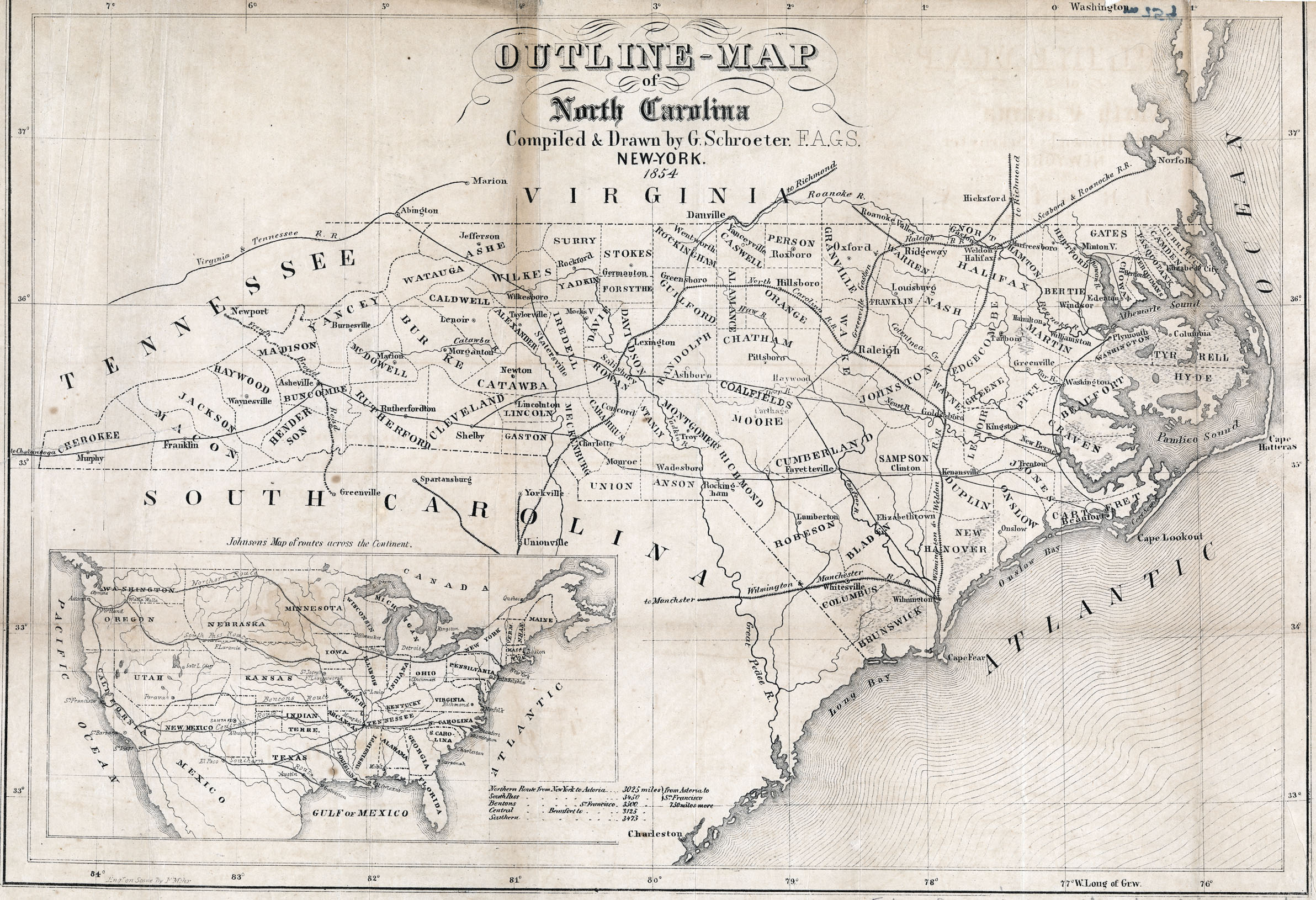
English: Map depicting the roads and railroads of North Carolina in 1854. |
| Date | |
| Source | http://www.learnnc.org/lp/multimedia/12394 |
| Author | G. Schroeter |
| Other versions |
 |
Licensing
| Public domainPublic domainfalsefalse |
This media file is in the public domain in the United States. This applies to U.S. works where the copyright has expired, often because its first publication occurred prior to January 1, 1929, and if not then due to lack of notice or renewal. See this page for further explanation.
|
 | |
 |
This image might not be in the public domain outside of the United States; this especially applies in the countries and areas that do not apply the rule of the shorter term for US works, such as Canada, Mainland China (not Hong Kong or Macao), Germany, Mexico, and Switzerland. The creator and year of publication are essential information and must be provided. See Wikipedia:Public domain and Wikipedia:Copyrights for more details.
|
Captions
Add a one-line explanation of what this file represents
Items portrayed in this file
depicts
1854
File history
Click on a date/time to view the file as it appeared at that time.
| Date/Time | Thumbnail | Dimensions | User | Comment | |
|---|---|---|---|---|---|
| current | 08:04, 15 June 2010 | | 2,384 × 1,630 (1.06 MB) | MarmadukePercy | {{Information |Description={{en|1=Map depicting the roads and railroads of North Carolina in 1854.}} |Source=http://www.learnnc.org/lp/multimedia/12394 |Author=G. Schroeter |Date=1854 |Permission= |other_versions= }} Category:Maps of North Carolina |
File usage
The following pages on the English Wikipedia use this file (pages on other projects are not listed):
Global file usage
The following other wikis use this file:
- Usage on arz.wikipedia.org
- Usage on ja.wikipedia.org
- Usage on ru.wikipedia.org
Metadata
This file contains additional information, probably added from the digital camera or scanner used to create or digitize it.
If the file has been modified from its original state, some details may not fully reflect the modified file.
| Width | 5,066 px |
|---|---|
| Height | 4,258 px |
| Compression scheme | Uncompressed |
| Pixel composition | RGB |
| Orientation | Normal |
| Number of components | 3 |
| Horizontal resolution | 300 dpi |
| Vertical resolution | 300 dpi |
| Data arrangement | chunky format |
| Software used | Adobe Photoshop CS4 Macintosh |
| File change date and time | 11:37, 18 June 2009 |
| Color space | Uncalibrated |