File:Map_Greece_expansion_1832-1947-en.svg
From Wikipedia, the free encyclopedia

Size of this PNG preview of this SVG file: 456 × 599 pixels. Other resolutions: 183 × 240 pixels | 365 × 480 pixels | 584 × 768 pixels | 779 × 1,024 pixels | 1,559 × 2,048 pixels | 730 × 959 pixels.
Original file (SVG file, nominally 730 × 959 pixels, file size: 469 KB)
| This is a file from the Wikimedia Commons. Information from its description page there is shown below. Commons is a freely licensed media file repository. You can help. |
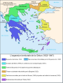
| DescriptionMap Greece expansion 1832-1947-en.svg |
Čeština: Mapa zobrazuje územní expanzi Řeckého království (1832–1947). Dansk: Kort over Grækenlands territoriale udvidelser, 1832-1947. Deutsch: Territoriale Expansion Griechenlands 1832-1947. English: The territorial expansion of Greece, 1832-1947. Español: Mapa de la expansión territorial griega (1832-1947) Euskara: Greziaren lurralde hedapena 1832-1947 bitartean Français : L'expansion territoriale de la Grèce. 1832-1947. Hrvatski: Teritorijalno proširenje Grčke u razdoblju od 1832. do 1947. Italiano: L'espansione territoriale della Grecia dal 1832 al 1947 Magyar: Görögország területi növekedése (1832-1947) Occitan : Evolucions territòrialas de Grècia. Ελληνικά: Η εδαφική επέκταση της Ελλάδας 1832-1947. Македонски: Територијално проширување на Грција Українська: Територіальна експансія Греції (1832-1947). 日本語: ギリシャ王国の版図拡大 (1832-1947年) 中文: 希腊的领土变迁,1832年-1947年间。 العربية : خريطة تُصوِّر الأراضي التي استولت عليها اليونان مُنذُ سنة 1832م حين استقلالها عن الدولة العُثمانيَّة، وُصولًا إلى سنة 1947م |
||||||||
| Date | |||||||||
| Source |
Own work based on: Map Greece expansion 1832-1947-fr.svg References: Ortolland, Didier (2009-04-10). The Greco-Turkish dispute over the Aegean Sea : a possible solution ? [Greece's borders since 1830]. Diploweb. |
||||||||
| Author | Historicair, translator Rursus | ||||||||
| Permission (Reusing this file) |
|
||||||||
| Other versions |
Derivative works of this file: [edit]
|


.PNG)


.png)


Captions
Add a one-line explanation of what this file represents
اتفاقية القسطنطينية (1881م)،
Items portrayed in this file
depicts
31 March 2007
image/svg+xml
File history
Click on a date/time to view the file as it appeared at that time.
| Date/Time | Thumbnail | Dimensions | User | Comment | |
|---|---|---|---|---|---|
| current | 10:27, 27 December 2019 | | 730 × 959 (469 KB) | Cplakidas | corrections: N. Epirus was not occupied in 1918-23, but in 1912-14 and 1914-16; eastern Aegean islands were assigned only at the Protocol of Florence in 1914. And vectorize text |
| 02:25, 6 April 2012 |  | 730 × 959 (95 KB) | Ras67 | better | |
| 02:01, 6 April 2012 |  | 731 × 960 (95 KB) | Ras67 | cropped | |
| 14:46, 5 December 2008 |  | 734 × 962 (119 KB) | Future Perfect at Sunrise | marked present border | |
| 12:31, 5 December 2008 |  | 734 × 962 (110 KB) | Future Perfect at Sunrise | corrected "Western Thrace"; tweaked some captions | |
| 11:10, 31 March 2007 |  | 734 × 962 (110 KB) | Rursus |
File usage
The following pages on the English Wikipedia use this file (pages on other projects are not listed):
Global file usage
The following other wikis use this file:
- Usage on an.wikipedia.org
- Usage on azb.wikipedia.org
- Usage on az.wikipedia.org
- Usage on bg.wikipedia.org
- Usage on bn.wikipedia.org
- Usage on bs.wikipedia.org
- Usage on ca.wikipedia.org
- Usage on el.wikipedia.org
- Usage on fi.wikipedia.org
- Usage on fr.wikipedia.org
- Usage on hif.wikipedia.org
- Usage on ko.wikipedia.org
- Usage on mk.wikipedia.org
- Usage on pt.wikipedia.org
- Usage on ro.wikipedia.org
- Usage on ru.wikipedia.org
- Usage on sco.wikipedia.org
- Usage on tr.wikipedia.org
Metadata
This file contains additional information, probably added from the digital camera or scanner used to create or digitize it.
If the file has been modified from its original state, some details may not fully reflect the modified file.
| Width | 730.20001 |
|---|---|
| Height | 959.40002 |